Corn planting distribution extraction method based on high-resolution satellite data

A technology for satellite data and extraction methods, which is applied in instruments, character and pattern recognition, computer parts, etc.

Inactive Publication Date: 2021-11-19
CHINESE ACAD OF METEOROLOGICAL SCI +1
View PDF6 Cites 3 Cited by
  • Summary
  • Abstract
  • Description
  • Claims
  • Application Information

AI Technical Summary

Problems solved by technology

[0004] 1. Since the growth period of corn and the crops sown at the same time are close, the spectral information is similar, and there is a phenomenon of mixed species, so it is difficult to distinguish using existing technologies
[0005] 2. At present, most remote sensing data sources are of medium and low resoluti...

Method used


Image

  • Corn planting distribution extraction method based on high-resolution satellite data
  • Corn planting distribution extraction method based on high-resolution satellite data

Examples


Embodiment Construction

[0026] The following will clearly and completely describe the technical solutions in the embodiments of the present invention with reference to the accompanying drawings in the embodiments of the present invention. Obviously, the described embodiments are only some, not all, embodiments of the present invention. Based on the embodiments of the present invention, all other embodiments obtained by persons of ordinary skill in the art without making creative efforts belong to the protection scope of the present invention.

[0027] In order to make the above objects, features and advantages of the present invention more comprehensible, the present invention will be further described in detail below in conjunction with the accompanying drawings and specific embodiments.

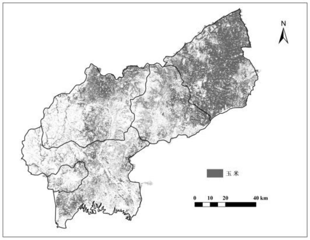
[0028] like figure 1 As shown, the invention provides a method for extracting corn planting distribution based on high-resolution satellite data, including:

[0029] S1. Select sample points of different land cov...


PUM


Abstract

The invention discloses a corn planting distribution extraction method based on high-resolution satellite data. The method comprises the following steps: collecting the high-resolution satellite data of a target research area, selecting sample points based on the high-resolution satellite data, and obtaining second remote sensing characteristic indexes; constructing a classification characteristic combination based on the second remote sensing characteristic indexes, and performing corn planting pixel extraction on the classification characteristic combination through a random forest algorithm to obtain a second corn planting distribution map; and obtaining the corn planting area of the target research area according to the second corn planting distribution map, and carrying out distribution statistical analysis on the corn planting area. According to the invention, corn planting distribution in a research area can be quickly, efficiently, cheaply and accurately extracted; and on one hand, the defect of low extraction precision of the corn planting distribution caused by low resolution of remote sensing data in an existing extraction method is overcome, and on the other hand, the defect that it is difficult to distinguish corn from other crops in the same growing season in the existing extraction method is overcome.

Description

technical field [0001] The invention belongs to the field of remote sensing extraction of corn planting distribution, in particular to a method for extracting corn planting distribution based on high-resolution satellite data. Background technique [0002] As an important industrial raw material, feed and food crop in my country, corn has the largest room for growth in national consumption demand and plays an important role in promoting China's agricultural production and rural economic development. Timely and accurate acquisition of corn planting distribution information is of great significance to the domestic corn supply pattern, food security and sustainable agricultural development. [0003] Remote sensing technology has incomparable advantages over traditional methods in agricultural development, and can obtain information such as crop growth and yield in a timely and objective manner, especially planting distribution information. Many scholars at home and abroad have...

Claims


Application Information

Patent Timeline
IPC IPC(8): G06K9/62G06K9/32
CPCG06F18/24323G06F18/214
Inventor 周广胜郭玉超任鸿瑞刘二华
Owner CHINESE ACAD OF METEOROLOGICAL SCI
Why Eureka
Try Eureka