Landslide mass recognition method based on Laplacian pyramid remote sensing image fusion

A remote sensing image fusion and recognition method technology, applied in the field of landslide body recognition based on Laplacian pyramid remote sensing image fusion, can solve problems such as spectral distortion, information redundancy, and inability to make full use of multi-source data, and achieve data resolution Difficult to obtain and solve the effect of low recognition accuracy

Active Publication Date: 2021-11-23
NANJING UNIV OF INFORMATION SCI & TECH
View PDF5 Cites 4 Cited by
  • Summary
  • Abstract
  • Description
  • Claims
  • Application Information

AI Technical Summary

Problems solved by technology

[0003] However, the above-mentioned technologies still have the following shortcomings: 1. The accuracy of the traditional remote sensing landslide identification method is not high, it is difficult to exceed 90%, and it is limited by factors such as available data; 2. Due to the different observation dimensions of multi-source remote sensing, the time of image , Spatial and spectral resolutions are different, which makes the information redundant and cannot make full use of the advantages of multi-source data, and the algorithm based on image fusion generally has serious spatial and spectral distortion problems

Method used


Image

  • Landslide mass recognition method based on Laplacian pyramid remote sensing image fusion
  • Landslide mass recognition method based on Laplacian pyramid remote sensing image fusion
  • Landslide mass recognition method based on Laplacian pyramid remote sensing image fusion

Examples


Embodiment Construction

[0029] The present invention will be further described in detail below in conjunction with the accompanying drawings and specific embodiments.

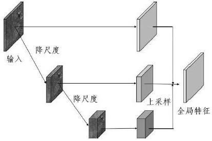
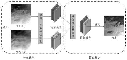
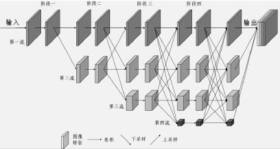
[0030] The landslide recognition method of the present invention enhances the image by effectively fusing multi-source remote sensing images, and then uses a deep learning semantic segmentation network to accurately monitor landslide disasters. The present invention uses image fusion and semantic segmentation technology in deep learning as a research framework, which includes a multi-source remote sensing image fusion module and a landslide recognition module: first, the multi-source remote sensing image fusion module is used to extract non-local information from the entire image to obtain the original image The multi-scale, multi-dimensional, and multi-angle features are used to reconstruct the input image to enhance the difference of adjacent features in the original image, and obtain high-resolution images that can better distinguis...


PUM


Abstract

The invention discloses a landslide mass recognition method based on Laplacian pyramid remote sensing image fusion. The method comprises the steps: reconstructing an original remote sensing image through a Laplacian pyramid fusion module according to the extracted local features and global features of the remote sensing image, and generating a fusion image; constructing a deep learning semantic segmentation model through a semantic segmentation network; then respectively marking places where landslide disasters occur and places where landslide disasters do not occur in the fused image through a picture marking tool to obtain a landslide disaster tag map data set; and finally, training a deep learning semantic segmentation model by using the data set, and storing the model by modifying a semantic segmentation network structure and adjusting model parameters until a loss curve of the model reaches fitting and when the precision of recognizing the landslide mass in the remote sensing image meets the requirement. According to the method, an image fusion model based on the Laplacian pyramid is combined, and an effective decision basis can be efficiently and accurately provided for disaster prevention and reduction of landslide disasters.

Description

technical field [0001] The invention relates to a landslide body recognition method, in particular to a landslide body recognition method based on Laplacian pyramid remote sensing image fusion. Background technique [0002] As one of the most dangerous natural disasters, landslides are generally defined as natural phenomena in which soil or rock on a slope slides down the slope under the action of gravity under the influence of factors such as river erosion and earthquakes. It often occurs in mountainous areas. , hills and other areas. Landslide disasters are highly destructive and pose a huge threat to the ecological environment, transportation, and construction land. The resulting casualties and property losses are huge. Therefore, it is necessary to monitor landslides in real time to reduce losses. It is difficult to systematically identify landslides because of their unpredictable occurrence, scattered distribution and complex topography in the disaster area. In recent...

Claims


Application Information

Patent Timeline
Patent Type & Authority Applications(China)
IPC IPC(8): G06K9/00G06K9/46G06K9/62G06N3/04G06N3/08
CPCG06N3/08G06N3/045G06F18/24G06V20/13G06V20/70G06V10/26G06V10/82G06V10/806G06V10/24G06V10/778G06V10/50G06V20/10G06T3/40
Inventor 董臻王国杰梁子凡冯爱青王国复王艳君苏布达
Owner NANJING UNIV OF INFORMATION SCI & TECH
Why Eureka
Try Eureka