
Road surface surveying and mapping device based on the Internet of Things

A surveying and mapping device and Internet of Things technology, which is applied in the direction of measuring devices, surveying and navigation, and measuring instruments, can solve the problems of inconvenient transportation and inconvenient leveling, etc., and achieve the effects of increasing speed, ensuring life expectancy, and reducing fatigue

Inactive Publication Date: 2021-11-26
深圳市沁鼎源科技有限公司
View PDF0 Cites 0 Cited by
  • Summary
  • Abstract
  • Description
  • Claims
  • Application Information

AI Technical Summary

Problems solved by technology

[0003] The purpose of the present invention is to provide a road surface surveying and mapping device based on the Internet of Things, which has the advantages of convenient leveling and convenient transportation, and solves the problems of inconvenient leveling and inconvenient transportation of existing surveying and mapping devices

Method used


Image

  • Road surface surveying and mapping device based on the Internet of Things
  • Road surface surveying and mapping device based on the Internet of Things
  • Road surface surveying and mapping device based on the Internet of Things

Examples


Embodiment Construction

[0020] The following will clearly and completely describe the technical solutions in the embodiments of the present invention with reference to the accompanying drawings in the embodiments of the present invention. Obviously, the described embodiments are only some, not all, embodiments of the present invention. Based on the embodiments of the present invention, all other embodiments obtained by persons of ordinary skill in the art without making creative efforts belong to the protection scope of the present invention.

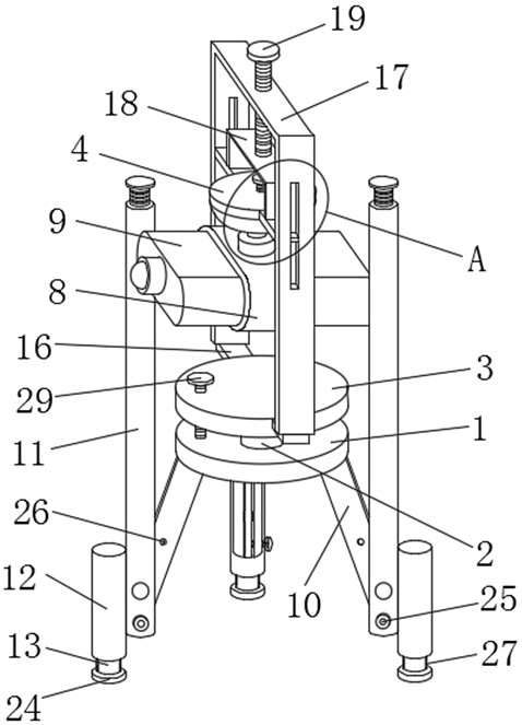
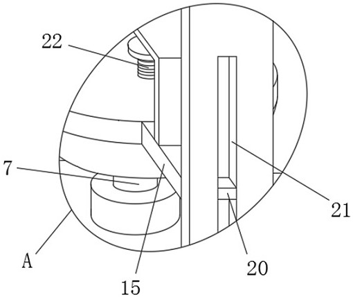
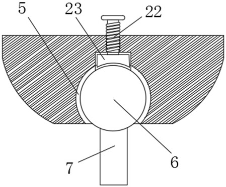
[0021] see Figure 1-4 As shown, a road surface surveying device based on the Internet of Things includes a first board body 1, the top of the first board body 1 is rotatably connected to a support rod 2 through a bearing, and the top of the support rod 2 is fixedly sleeved with a second board body 3 , the top of the second plate body 3 is provided with a fixed block 4, the bottom of the fixed block 4 is provided with a universal groove 5, the inside of the un...


PUM


Abstract

The invention relates to the technical field of road engineering equipment, and discloses a road surface surveying and mapping device based on the Internet of Things, the road surface surveying and mapping device comprises a first plate body, the top of the first plate body is rotatably connected with a supporting rod through a bearing; the universal groove is formed in the bottom of the fixing block, the universal bead is slidably connected into the universal groove, and the connecting rod is used in cooperation, so that the clamping frame can drive the three-dimensional laser scanner to be always in a horizontal state under the action of gravity, repeated debugging by workers is not needed, the fatigue degree of the workers is reduced, limiting sleeves are mounted on threaded supporting legs at the bottom of a supporting plate, so that supporting rods can have a certain buffering and energy absorbing function under the action of damping springs, energy absorption and shock absorption can be performed during transportation of the device, the device can be transported without being disassembled and boxed, and a connecting part of the surveying and mapping device cannot be abraded; and the service life of the surveying and mapping device is ensured.

Description

technical field [0001] The invention relates to the technical field of road engineering equipment, in particular to a road surface surveying and mapping device based on the Internet of Things. Background technique [0002] Surveying usually refers to the general term of various surveying theories, methods and technologies used in the survey design, construction and management stages of engineering construction. In road engineering, surveying and mapping devices are often required for surveying. Existing surveying and mapping devices are generally based on The 3D laser scanner of the Internet of Things, the existing 3D laser scanner is generally divided into the support part and the surveying and mapping part. There are still some problems in the use of the existing 3D laser scanner. When it is placed on the road, it needs to be adjusted Leveling, the existing leveling method is generally to adjust the height of the support part, which requires repeated tests by the staff to ...

Claims


Application Information

Patent Timeline
Patent Type & Authority Applications(China)
IPC IPC(8): G01C15/00G01D11/30
CPCG01C15/00G01D11/30
Inventor 罗彩霞
Owner 深圳市沁鼎源科技有限公司
Learn More