
A method of correcting flight attitude photos based on open source dem data

A flight attitude and data technology, applied in the field of image processing, can solve problems such as error, aircraft deviation, and research affecting the flight attitude of the aircraft, and achieve the effects of improving quality, accurate flight attitude, and clear edge contours.

Active Publication Date: 2022-01-04
四川格锐乾图科技有限公司
View PDF14 Cites 0 Cited by
  • Summary
  • Abstract
  • Description
  • Claims
  • Application Information

AI Technical Summary

Problems solved by technology

[0003] During the flight of the aircraft in the air, due to the influence of the natural wind direction or the environment, there are often errors between the flight attitude of the aircraft in the air and the flight attitude that the flight control system actually needs to control. For example, the flight control system needs to control the tilt angle of the aircraft. 30 degrees, but due to the effect of wind, the aircraft often has a certain deviation from 30 degrees during flight, which makes there are large errors when capturing the photos of the aircraft's flight attitude, which affects the research on the aircraft's flight attitude

Method used


Image

  • A method of correcting flight attitude photos based on open source dem data

Examples


Embodiment Construction

[0045] Specific embodiments of the present invention are described below so that those skilled in the art can understand the present invention, but it should be clear that the present invention is not limited to the scope of specific embodiments. For those of ordinary skill in the art, as long as various changes Within the spirit and scope of the present invention defined and determined by the appended claims, these changes are obvious, and all inventions and creations using the concept of the present invention are included in the protection list.

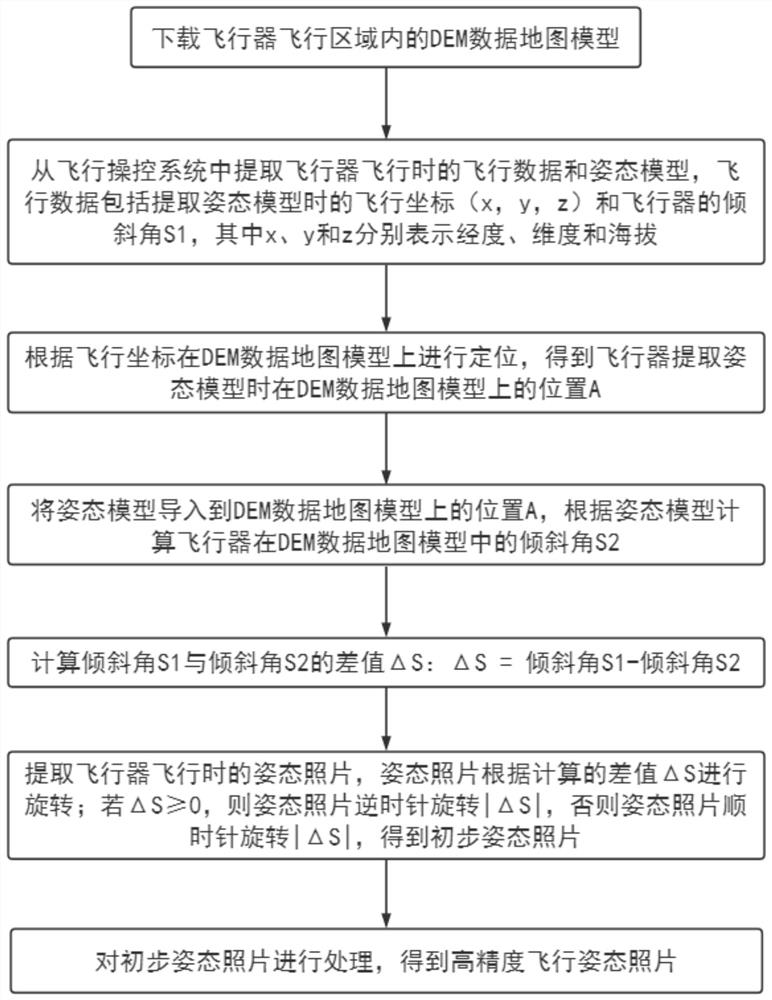
[0046] Such as figure 1Described, the flight attitude photo correction method based on the open source DEM data of this program comprises the following steps:

[0047] S1: Download the DEM data map model in the flight area of ​​the aircraft; the present invention can use SRTM topographic data, which can be divided into SRTM1 and SRTM3 according to the accuracy, and the corresponding resolution accuracy is 30 meters and 90 meters da...


PUM


Abstract

The invention discloses a method for correcting flight attitude photos based on open-source DEM data, which comprises the following steps: S1: downloading the DEM data map model in the flight area of ​​the aircraft; S2: extracting the flight data and data of the aircraft during flight from the flight control system Attitude model; S3: Positioning on the DEM data map model according to the flight coordinates; S4: Calculate the tilt angle S of the aircraft in the DEM data map model according to the attitude model 2 ;S5: Calculate the inclination angle S 1 with inclination angle S 2 ΔS; S6: preliminary attitude photo; S7: process the preliminary attitude photo to obtain a high-precision flight attitude photo. According to the influence of environmental factors on the flight attitude, the invention adjusts the angle of the flight attitude photo to ensure that the flight attitude on the photo is not affected by the environment, and the displayed flight attitude is accurate enough to facilitate the later research on the control of the flight attitude.

Description

technical field [0001] The invention relates to the technical field of image processing, in particular to a method for correcting a flight attitude photo based on open source DEM data. Background technique [0002] DEM is the English abbreviation of Digital Elevation Model (Digital Elevation Model), which is an important original data for research and analysis of terrain, watershed, and object recognition. Since DEM data can reflect local topographic features with a certain resolution, a large amount of surface morphology information can be extracted through DEM, which can be used to draw contour lines, slope maps, slope aspect maps, stereoscopic perspective maps, and stereoscopic landscape maps. Orthophotos, 3D terrain models and map revisions. It has a wide range of applications in surveying and mapping, hydrology, meteorology, geomorphology, geology, soil, engineering construction, communications, military and other national economy and national defense construction, as ...

Claims


Application Information

Patent Timeline
Patent Type & Authority Patents(China)
IPC IPC(8): G05D1/08G06T3/40
CPCG05D1/0808G06T3/4038
Inventor 余国李文平吴成勇何晓波赖云余斌宁应来信小伟王勇唐俊垚
Owner 四川格锐乾图科技有限公司
Learn More