
Vegetation index fusion method based on multi-source data

A technique of vegetation index and fusion method, which is applied in the direction of instruments, analysis materials, computer components, etc., can solve the problems of low temporal and spatial resolution and estimation accuracy of vegetation coverage on the ground, and achieve improved temporal and spatial resolution, estimation accuracy, and accurate data supported effect

Pending Publication Date: 2021-12-07
甘肃中星鸿图科技有限公司 +1
View PDF0 Cites 0 Cited by
  • Summary
  • Abstract
  • Description
  • Claims
  • Application Information

AI Technical Summary

Problems solved by technology

[0003] Aiming at the above-mentioned deficiencies in the prior art, a vegetation index fusion method based on multi-source data provided by the present invention solves the problem of low temporal and spatial resolution and estimation accuracy of surface vegetation coverage

Method used


Image

  • Vegetation index fusion method based on multi-source data
  • Vegetation index fusion method based on multi-source data
  • Vegetation index fusion method based on multi-source data

Examples


Embodiment Construction

[0022] The specific embodiments of the present invention are described below so that those skilled in the art can understand the present invention, but it should be clear that the present invention is not limited to the scope of the specific embodiments. For those of ordinary skill in the art, as long as various changes Within the spirit and scope of the present invention defined and determined by the appended claims, these changes are obvious, and all inventions and creations using the concept of the present invention are included in the protection list.

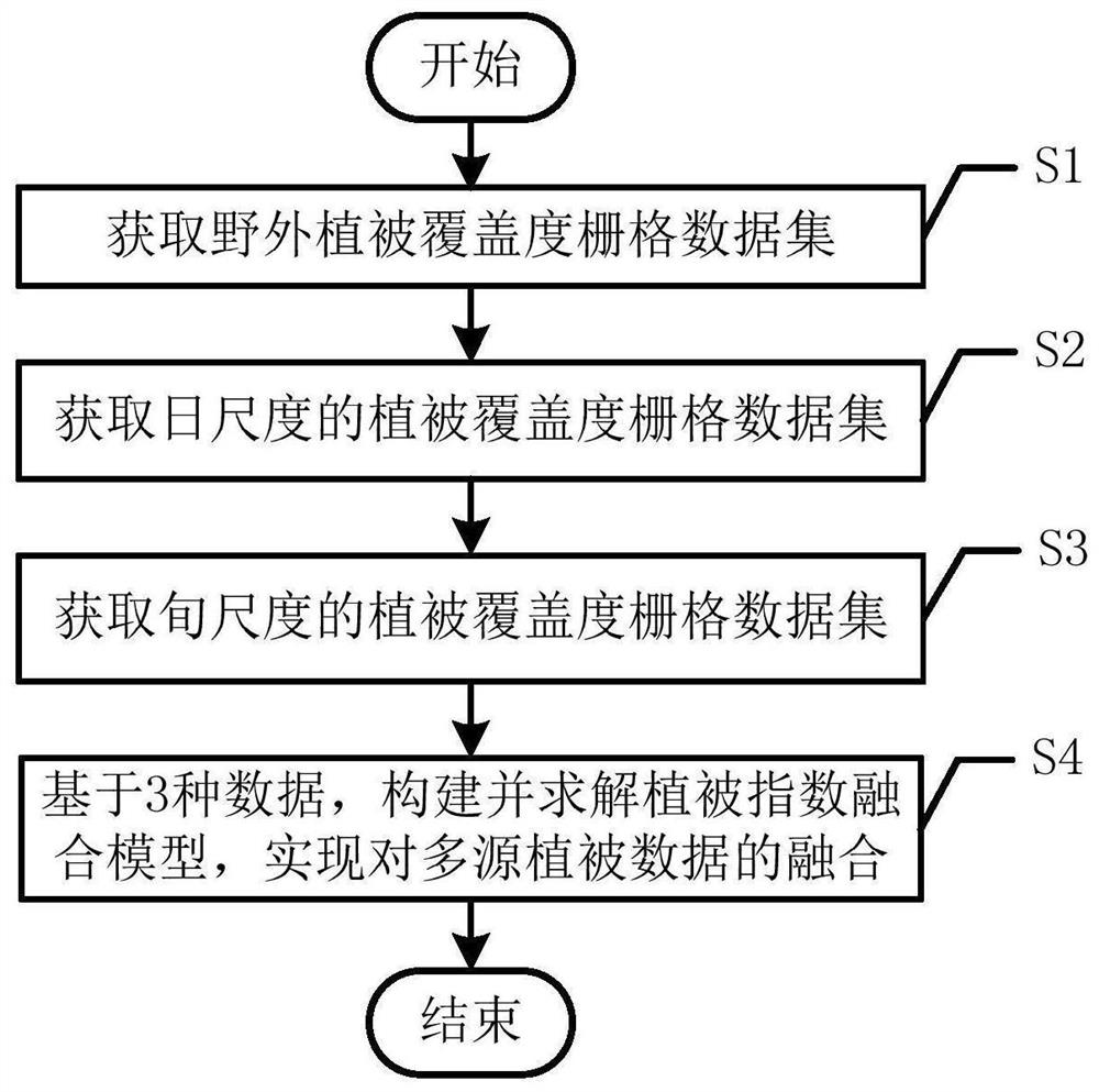
[0023] like figure 1 As shown, a vegetation index fusion method based on multi-source data includes the following steps:

[0024] S1. Obtain the field vegetation coverage data set in the research area, and use the geographic regression weighting model to perform spatial rasterization processing on the field vegetation coverage data set to obtain the field vegetation coverage raster data set;

[0025] In this embodiment, st...


PUM


Abstract

The invention discloses a vegetation index fusion method based on multi-source data, and the method comprises the following steps: S1, carrying out the spatial rasterization of a field vegetation coverage data set through employing a geographic regression weighting model, and obtaining a field vegetation coverage raster data set; S2, acquiring related data of the research area influencing the surface vegetation coverage, and calibrating a biogeochemical model Biome-BGC based on the related data to obtain a daily-scale vegetation coverage raster data set; S3, obtaining the vegetation coverage collected by AVHRR and MODIS sensors of the Terra satellite in the research area, and carrying out scale conversion on the vegetation coverage to obtain a vegetation coverage raster data set of a ten-day scale; S4, based on the three data sets, constructing and solving a vegetation index fusion model to realize fusion of multi-source vegetation data; according to the method, the problems of low temporal-spatial resolution and estimation precision of the surface vegetation coverage are solved.

Description

technical field [0001] The invention relates to the technical field of ecological remote sensing, in particular to a vegetation index fusion method based on multi-source data. Background technique [0002] Vegetation coverage is an important indicator of surface vegetation coverage. It is closely related to surface vegetation coverage, soil erosion, land desertification, and global climate change. It is an important parameter for ecological environment change, global and regional climate models. Therefore, it is of great practical significance to obtain higher spatial and temporal resolution of surface vegetation coverage and its change information for revealing the law of surface space change, exploring the driving factors of change, and analyzing and evaluating the regional ecological environment. Contents of the invention [0003] In view of the above-mentioned deficiencies in the prior art, the invention provides a vegetation index fusion method based on multi-source d...

Claims


Application Information

Patent Timeline
Patent Type & Authority Applications(China)
IPC IPC(8): G06K9/62G01N21/17G01S19/38
CPCG01N21/17G01S19/38G01N2021/1797G06F18/251Y02A90/10
Inventor 雷添杰李小涵岳建伟张平徐瑞瑞张保山鲁源
Owner 甘肃中星鸿图科技有限公司
Learn More