Spatio-temporal missing data completion method, device and medium based on multi-view learning

A missing data, multi-view technology, applied in the field of geographic information (GIS), can solve the problems affecting the real-time monitoring of the ocean, missing data, affecting the performance of data analysis, prediction and inference, etc., to achieve good nonlinear relationship fitting ability, well estimated effect

Active Publication Date: 2022-02-18
ZHEJIANG UNIV
View PDF4 Cites 0 Cited by
  • Summary
  • Abstract
  • Description
  • Claims
  • Application Information

AI Technical Summary

Problems solved by technology

However, data loss also occurs from time to time due to transmission errors, sensor failures, and equipment maintenance
These missing values ​​not only affect the real-time monitoring of the ocean (especially in emergency situations), but also affect the performance of further analysis, prediction and inference of the data

Method used


Image

  • Spatio-temporal missing data completion method, device and medium based on multi-view learning
  • Spatio-temporal missing data completion method, device and medium based on multi-view learning
  • Spatio-temporal missing data completion method, device and medium based on multi-view learning

Examples


Embodiment

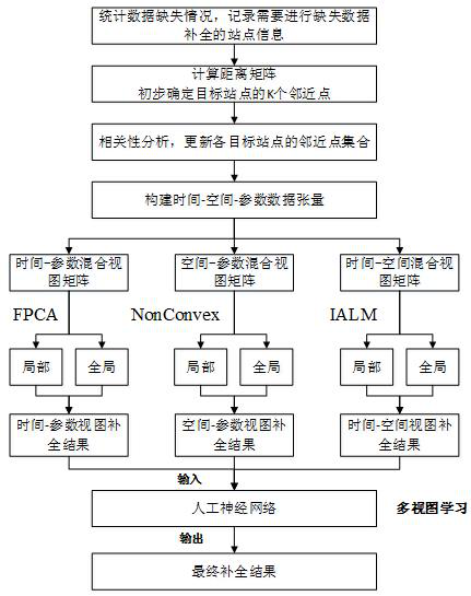
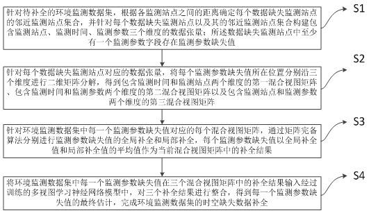
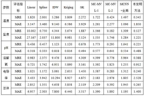
[0063] The following is an example of Zhejiang offshore buoy monitoring data set to complete the missing data. This data set contains historical monitoring data of different buoy stations. Each buoy station monitors multiple water quality index parameters and stores the monitoring results in time series. Parameters on display include temperature, salinity, pH, dissolved oxygen and conductivity. The data set collected experimental data from 16 buoys from February 1, 2016 to July 31, 2016, with a total of 1092 data moments, and the monitoring time interval was 4 hours.

[0064] In the complementary test of this example, the monitoring data set of offshore buoys in Zhejiang was established as a relational database, and their position coordinate information, monitoring parameter values ​​and monitoring time information were recorded. After the data is processed, the missing data of each station is counted, and the overall missing rate of the monitoring data is set to 0.1, and the ...


PUM


Abstract

The invention discloses a method, device and medium for complementing missing data in time and space based on multi-view learning. The method aims at massive and multi-type environmental monitoring data sets, and constructs each data missing monitoring site including monitoring site, monitoring time, etc. , monitoring parameter data tensor in three dimensions, and decompose three mixed view matrices, use the matrix complete algorithm to estimate the missing data from the local and global scales for the three mixed views constructed, and then perform multiple View learning to obtain the estimation results of the missing values ​​of the final monitoring parameters. The invention can complete the missing value of the environmental monitoring data set, and has important significance in the fields of marine environment monitoring, smart city development and the like.

Description

technical field [0001] The invention relates to the technical field of geographic information (GIS), in particular to a method for completing missing values ​​in spatio-temporal big data based on an artificial neural network. Background technique [0002] With the rapid development of "space, space, earth and sea" stereoscopic observation technology, high-precision, high-frequency, and large-coverage big data with spatio-temporal attributes are rapidly accumulating and forming massive multi-type earth observation spatio-temporal datasets. At the same time, problems such as inaccurate spatio-temporal modeling and untimely analysis and prediction brought about by the lack of data have brought huge challenges to disaster early warning, urban monitoring and other research. Taking offshore buoy data as an example, the marine environment monitoring based on the buoy system has the characteristics of high frequency, real-time and low cost. Used to provide early warning of marine h...

Claims


Application Information

Patent Timeline
Patent Type & Authority Patents(China)
IPC IPC(8): G06F16/215G06F16/29G06N3/04G06N3/08
CPCG06F16/215G06F16/29G06N3/084G06N3/045
Inventor 杜震洪覃梦娇张丰汪愿愿吴森森刘仁义
Owner ZHEJIANG UNIV
Why Eureka
Try Eureka