
Blanket-loaded gnss buoy for measuring two-dimensional sea surface height and measuring method

A technology for buoys and heights, applied in buoys, measuring devices, height/horizontal measurements, etc., can solve problems such as increased cost processing work, difficult estimation and monitoring of GNSS antennas, high-precision sea surface topology and terrain reconstruction with high resolution, etc.

Active Publication Date: 2022-03-08
OCEAN UNIV OF CHINA
View PDF5 Cites 0 Cited by
  • Summary
  • Abstract
  • Description
  • Claims
  • Application Information

AI Technical Summary

Problems solved by technology

Existing GNSS buoy equipment is mainly free-floating, mooring or anchoring, which has the limitation of only point sea surface elevation measurement; and due to its own mass load changes, water density changes, etc., it is difficult to continuously estimate and monitor the GNSS antenna height at sea level
Although some buoys can obtain the height from the antenna to the sea surface through the acoustic altimeter or radar altimeter, this not only increases the cost and post-processing work, but also these two altimeters have higher requirements on the environment
In addition, traditional GNSS buoys can only measure point positions, and it is difficult to reconstruct high-precision sea surface topography through on-site observation equipment

Method used


Image

  • Blanket-loaded gnss buoy for measuring two-dimensional sea surface height and measuring method
  • Blanket-loaded gnss buoy for measuring two-dimensional sea surface height and measuring method
  • Blanket-loaded gnss buoy for measuring two-dimensional sea surface height and measuring method

Examples


Embodiment 1

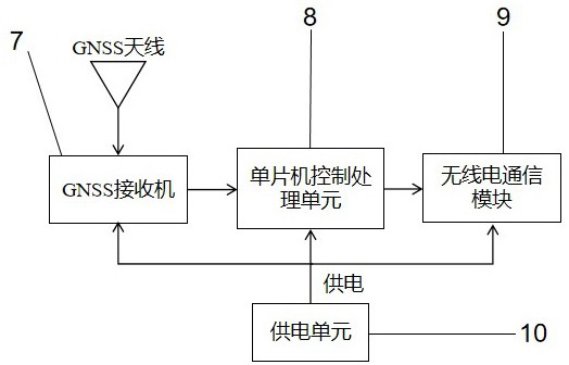
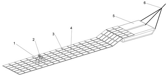
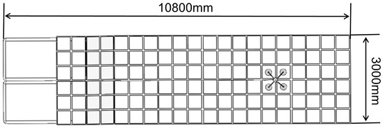
[0042] A blanket-mounted GNSS buoy for measuring 2D sea surface height, such as figure 2 As shown, it includes a main floating carpet 3, and the floating carpet 3 is fixed on a rubber boat 5, and the rubber boat 5 is equipped with a GNSS receiver, a wireless communication module, a single-chip control processing unit 9 and a power supply unit 10; A GNSS antenna 2 is fixed on the blanket 3 and is connected to the GNSS receiver 7 through an antenna cable 4 . The blanket-carrying GNSS buoy also includes a traction rope 6 , which is tied to the rubber boat 5 , and the other end is fixed on the boat for towing the rubber boat, thereby making the floating blanket 3 move. The floating carpet 3 is formed of a plurality of buoyancy modules in a carpet shape, so as to ensure that the floating carpet can be close to the sea surface and accurately follow the waves without additional movement.

[0043] like figure 1 As shown, the GNSS antenna 2 is fixed on the floating carpet 3, and is ...

Embodiment 2

[0047] A sea surface height measurement method applied to the new marine blanket-borne GNSS buoy in Example 1, such as Figure 5 shown, including:

[0048] S1: Carry out the buoy measurement plan according to the size of the measured sea area, and use the ship to drag the buoy through the traction rope for observation according to the plan; location and elevation information.

[0049] Measure the draft H of the floating blanket dra and the distance between the GNSS antenna and the bottom surface of the floating carpet ;

[0050] Draft of floating carpet near GNSS antenna:

[0051] (1)

[0052] In the formula, H dra is the draft of the floating carpet near the GNSS antenna, G is the total gravity of the four buoyancy modules, the four-legged gimbal bracket and the GNSS antenna, ρ is the seawater density in the sea area (measured by a seawater densitometer), g is the gravitational acceleration, S is the surface area of ​​the four buoyancy modules;

[0053] Due to the...


PUM


Abstract

The invention discloses a carpet-mounted GNSS buoy and a measurement method for measuring two-dimensional sea surface height, which belong to the technical field of ocean observation, and include a buoy body floating blanket, the floating blanket is fixed on a rubber boat, and the rubber boat is equipped with a GNSS receiver. computer, wireless communication module, single-chip microcomputer control processing unit and power supply unit; the GNSS antenna is fixed on the floating blanket, and is connected with the GNSS receiver through the antenna cable. The carpet-mounted GNSS buoy also includes a traction rope, which is tied to the rubber boat, and the other end is fixed on the boat for dragging the rubber boat, thereby making the floating blanket move. The invention provides a new acquisition method for the sea surface height of the one-dimensional section, provides high-precision sea surface terrain data, and solves the technical problem that the high-precision sea surface topography terrain is difficult to be reconstructed by high-resolution on-site observation equipment.

Description

technical field [0001] The invention belongs to the technical field of ocean observation, and in particular relates to a blanket-borne GNSS buoy for measuring two-dimensional sea surface height and a measuring method. Background technique [0002] With the development of GNSS technology, GNSS-based buoy measurement equipment has gradually matured, and has achieved important applications in sea surface height measurement and altimeter calibration. The existing GNSS buoy equipment is mainly free-floating, mooring or mooring, and has the limitation that only point-to-point sea surface elevation measurement can be performed; and due to changes in its own mass load and water density, it is difficult to continuously estimate and monitor the height of the GNSS antenna. at sea level. Although some buoys can now obtain the height from the antenna to the sea surface through an acoustic altimeter or a radar altimeter, this not only increases the cost and post-processing work, but also...

Claims


Application Information

Patent Timeline
Patent Type & Authority Patents(China)
IPC IPC(8): G01C5/00G01S19/42G01S19/14B63B22/00
CPCG01C5/00G01S19/42G01S19/14B63B22/00B63B2022/006
Inventor 马纯永杨守恒杨杰狄建锴陈戈高占文郑广东潘李超
Owner OCEAN UNIV OF CHINA
Learn More