Device and method for measuring water surface elevation and plane coordinates of river channel

A technology of plane coordinates and measuring devices, which is applied in directions such as buoy liquid level indicators, and can solve problems such as inaccurate data

Active Publication Date:
View PDF13 Cites 0 Cited by
  • Summary
  • Abstract
  • Description
  • Claims
  • Application Information

AI Technical Summary

Problems solved by technology

[0003] In view of this, the present invention proposes a device and method for measuring river water surface elevation and plane coordinates, aiming to solve the problem of inaccurate data caused by external interference in existing water level measurement

Method used


Image

  • Device and method for measuring water surface elevation and plane coordinates of river channel
  • Device and method for measuring water surface elevation and plane coordinates of river channel
  • Device and method for measuring water surface elevation and plane coordinates of river channel

Examples


Embodiment Construction

[0042] Exemplary embodiments of the present disclosure will be described in more detail below with reference to the accompanying drawings. Although exemplary embodiments of the present disclosure are shown in the drawings, it should be understood that the present disclosure may be embodied in various forms and should not be limited by the embodiments set forth herein. Rather, these embodiments are provided for more thorough understanding of the present disclosure and to fully convey the scope of the present disclosure to those skilled in the art. It should be noted that, in the case of no conflict, the embodiments of the present invention and the features in the embodiments can be combined with each other. The present invention will be described in detail below with reference to the accompanying drawings and examples.

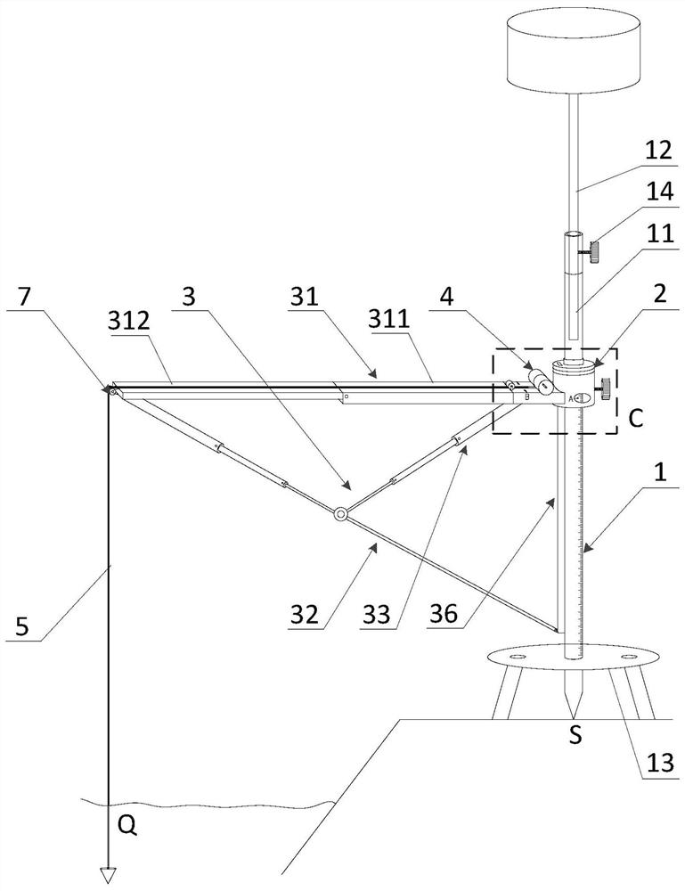
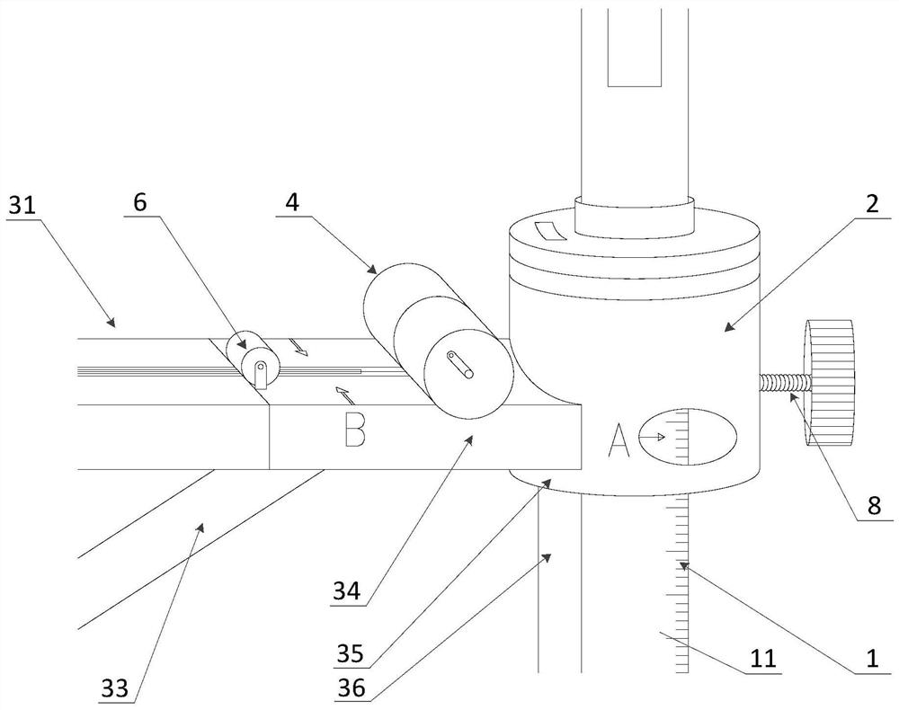
[0043] see Figure 1 to Figure 2 , which shows the preferred structure of the device for measuring the elevation and plane coordinates of the river channel w...


PUM


Abstract

The invention provides a device and a method for measuring water surface elevation and plane coordinates of a river channel. The device comprises an RTK centering rod; an angle measuring instrument is adjustably connected to the RTK centering rod along the length direction of the RTK centering rod; a folding overhanging bracket is arranged on the angle measuring instrument; a winding drum is rotatably arranged on the folding type overhanging support, and a plumb floating ruler is wound on the winding drum. According to the invention, the RTK centering rod is inserted and fixed, and the GIS technology is adopted to obtain the insertion and fixing point and the coordinate thereof, thereby ensuring accurate positioning; the folding overhanging bracket is driven by the angle measuring instrument to perform height adjustment and rotation, so that a cantilever end plumb bob of the plumb floating ruler reaches a to-be-measured point of the water surface of a river channel, and the GIS technology, a leveling principle and a total station angle measuring principle are combined to measure the water level data; the folding overhanging bracket can be telescopically folded, is easy to carry, and can be used for measuring anytime and anywhere.

Description

technical field [0001] The invention relates to the technical field of river surveying, in particular to a device and method for measuring the elevation and plane coordinates of the water surface of a river. Background technique [0002] In the current industrial and civil construction in our country, water level measurement refers to the determination of the position of the free surface of the water body, and is one of the important measurement items in hydraulic engineering, river engineering, and port engineering experiments. Water level measurement is often related to the elevation of the datum level, which has high requirements for the accuracy and long-term stability of the measuring instrument. In modern hydraulic tests, the measurement of water level uses computers to collect and process the data of water surface measurement in a centralized manner. The data results are susceptible to external interference, the operating equipment is cumbersome, and the construction...

Claims


Application Information

Patent Timeline
Patent Type & Authority Applications(China)
IPC IPC(8): G01F23/66
CPCG01F23/66Y02A90/30
Inventor 杨文明张松军卢亚军黄建滨林君伟
Why Eureka
Try Eureka