Spatial point cloud measurement system and calibration and reconstruction method

A technology of spatial point cloud and measurement system, applied in the field of point cloud measurement, can solve the problems of complex process, high production cost, low reliability, etc., and achieve the effects of simple system structure, easy cost control, and simple calibration.

Active Publication Date: 2022-01-18
NORTHWESTERN POLYTECHNICAL UNIV
View PDF10 Cites 0 Cited by
  • Summary
  • Abstract
  • Description
  • Claims
  • Application Information

AI Technical Summary

Problems solved by technology

Obtaining point clouds with binocular structured light and binocular cameras relies on the principle of triangulation, and the accuracy of point cloud acquisition is limited by the camera calibration accuracy, and the experimental scene requires good lighting conditions, making it difficult to complete high-precision measurement of a large field of view
Lidar currently has problems such as short laser tube life, low reliability, high production costs, and complicated processes.
The total station scanner uses a high-precision code disc to record angle information, the equipment is very expensive, the calibration and reconstruction process is relatively complicated, and there is still a lack of unified standards

Method used


Image

  • Spatial point cloud measurement system and calibration and reconstruction method
  • Spatial point cloud measurement system and calibration and reconstruction method
  • Spatial point cloud measurement system and calibration and reconstruction method

Examples


Embodiment 1

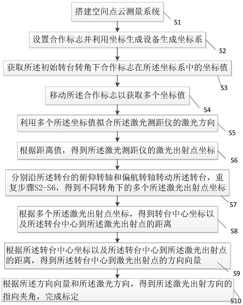
[0050] The technical scheme that the present invention solves the problems of the technologies described above is as follows:

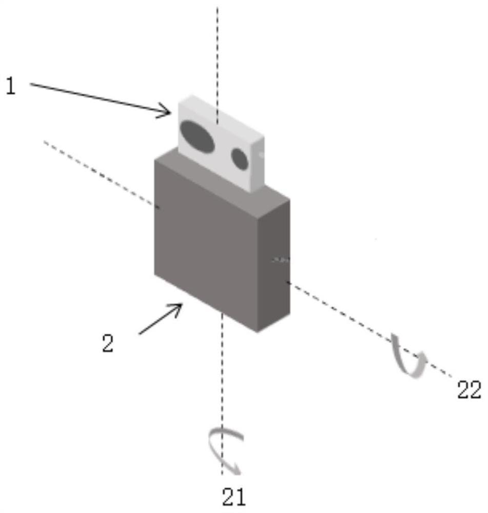
[0051] The present invention provides a space point cloud measurement system, referring to figure 2 As shown, the space point cloud measurement system includes:

[0052] A laser range finder 1, the laser range finder 1 is used to obtain the spatial distance information between the target to be measured and the laser range finder 1;

[0053] The turntable 2, the laser range finder 1 is fixed on the turntable 2, and the turntable 2 includes a pitch rotating shaft 22 and a yaw rotating shaft 21, and the axes of the pitch rotating shaft 22 and the yaw rotating shaft 21 are in space Inner intersection, used to provide angle information during spatial point cloud measurement;

[0054] A processor, the processor is used to obtain the spatial distance information and the angle information in the spatial point cloud measurement process; control the laser ra...

Embodiment 2

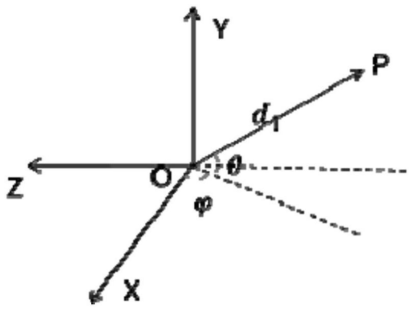
[0090] According to the first aspect of the present invention, the present invention provides a kind of space point cloud measurement system, comprises turntable 2, is used for obtaining the angle information of point cloud reconstruction on the surface of the object to be measured; Laser range finder 1, is fixed on turntable 2 , can rotate with the turntable 2, and is used to obtain the distance information of the point cloud reconstruction on the surface of the object to be measured; the processor obtains the surface of the object to be measured according to the distance measurement value of the laser rangefinder 1, the output rotation angle value of the turntable 2, and the parameters obtained by calibration Point cloud information, and then realize object measurement.

[0091] The present invention provides a calibration method for a space point cloud measurement system, wherein the calibration parameters are the distance from the rotation center of the turntable 2 to the l...


PUM


Abstract

The invention discloses a spatial point cloud measurement system and a calibration and reconstruction method. The spatial point cloud measurement system comprises a laser range finder which is used for obtaining the spatial distance information between a to-be-measured target and the laser range finder, and a rotary table, the laser range finder is fixedly arranged on the rotary table, the rotary table comprises a pitching rotating shaft and a yaw rotating shaft, and the axis of the pitching rotating shaft intersects with the axis of the yaw rotating shaft in the space so as to provide angle information in the space point cloud measurement process; the system further comprises a processor which is used for acquiring the spatial distance information and the angle information in the spatial point cloud measurement process, controlling the laser range finder and the rotary table to be switched between a working state and an idle state, and carrying out calibration and reconstruction on the spatial point cloud.

Description

technical field [0001] The invention relates to the technical field of point cloud measurement, in particular to a space point cloud measurement system and calibration and reconstruction methods. Background technique [0002] Point cloud is an important form to describe the geometric information of the object structure. After obtaining the point cloud information of the target object surface, it can continue to analyze the object position, category, movement and deformation. Target detection and analysis based on point cloud is widely used in structural deformation monitoring of bridges, dams, tunnels, etc., geological landslide early warning, automatic driving and other fields. [0003] Existing methods for obtaining spatial point clouds include binocular cameras, binocular structured light, lidar, and total station scanners. The acquisition of point clouds by binocular structured light and binocular cameras relies on the principle of triangulation. The accuracy of point c...

Claims


Application Information

Patent Timeline
Patent Type & Authority Applications(China)
IPC IPC(8): G01C15/00G01C3/00G01C25/00
CPCG01C15/00G01C3/00G01C25/00Y02A90/10
Inventor 郭翔袁莹涛葛振东索涛于起峰
Owner NORTHWESTERN POLYTECHNICAL UNIV
Why Eureka
Try Eureka