Downhole multi-sensor fusion low-power wireless positioning system with self-correction function

A wireless positioning system and multi-sensing technology, applied in the direction of reducing energy consumption, services based on location information, services based on specific environments, etc., can solve problems that easily affect positioning accuracy

Active Publication Date: 2022-01-21
CHINA UNIV OF MINING & TECH +1
View PDF9 Cites 0 Cited by
  • Summary
  • Abstract
  • Description
  • Claims
  • Application Information

AI Technical Summary

Problems solved by technology

[0003] Based on this, it is necessary to address the above technical problems and provide a self-correcting dow

Method used


Image

  • Downhole multi-sensor fusion low-power wireless positioning system with self-correction function
  • Downhole multi-sensor fusion low-power wireless positioning system with self-correction function
  • Downhole multi-sensor fusion low-power wireless positioning system with self-correction function

Examples


Embodiment Construction

[0018] In order to make the purpose, technical solutions and advantages of the present application clearer, the present application will be described in further detail below in conjunction with the accompanying drawings and embodiments. It should be understood that the specific embodiments described here are only used to explain the present application, not to limit the present application.

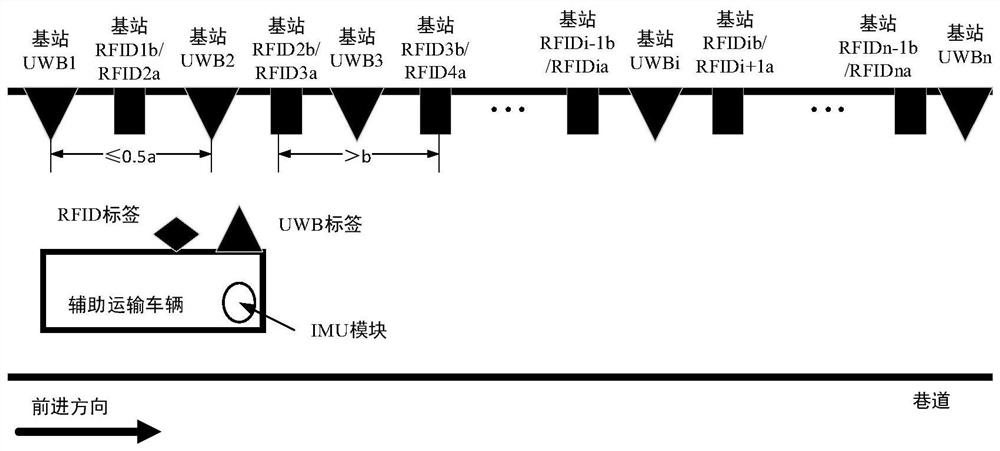
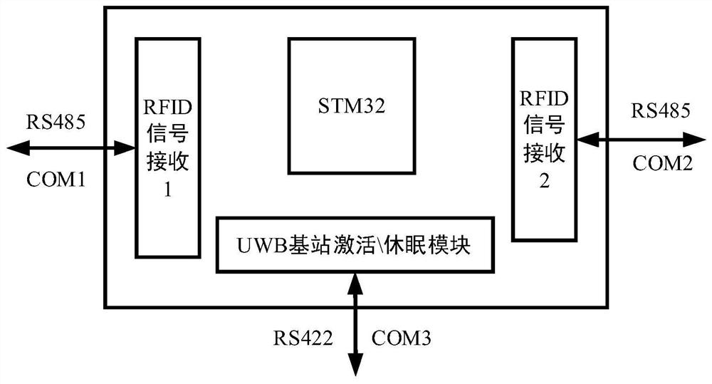
[0019] In one embodiment, a self-correcting downhole multi-sensor fusion low-power wireless positioning system is provided, including: UWB ranging base station, RFID base station, UWB tag, RFID tag, IMU module, embedded hardware platform and upper computer;

[0020] The preset number of UWB ranging base stations is based on the communication distance a between the UWB ranging base station and the UWB tag, and is equal to or less than 1 / 2 of the communication distance a. The same side blocked by foreign objects, and kept at the same level; RFID base stations are arranged in the middle pos...


PUM


Abstract

The invention relates to a downhole multi-sensor fusion low-power wireless positioning system with a self-correction function. The system is characterized in that a preset number of UWB ranging base stations are arranged on the same side of an underground coal mine roadway at equal intervals according to the communication distance a between the UWB ranging base stations and UWB tags and a size smaller than or equal to 1/2 of the communication distance a; each RFID base station is arranged at a middle position between every two UWB ranging base stations, and the distance between every two adjacent RFID base stations is larger than the communication distance b between the RFID base stations and the RFID tags; each UWB ranging base station and the RFID base stations on the two sides of the UWB ranging base station are connected with the same embedded hardware platform through a network; the RFID tags and the UWB tags are configured on one side, close to the arrangement direction of the UWB ranging base station, of a downhole auxiliary transport vehicle to be positioned; an IMU module is arranged on the downhole auxiliary transport vehicle to be positioned; and a upper computer is connected with the embedded hardware platform network and the IMU module network. The positioning precision is improved through fusion positioning of the IMU and the UWB.

Description

technical field [0001] This application relates to the technical field of underground positioning, in particular to an underground multi-sensor fusion low-power wireless positioning system with self-correction. Background technique [0002] In order to realize unmanned underground auxiliary transport vehicles to work autonomously, the first problem is the accurate positioning of auxiliary transport vehicles in coal mines. Most of the existing coal mine transport locomotives are located by manual inspection or based on RFID, ZigBee, Wi-Fi and UWB The positioning method of wireless communication technology, such as manual inspection, has high cost, low efficiency, long time, and great potential safety hazards. However, positioning only through wireless communication means that there are many large-scale power consumption due to the long and narrow coal mine underground roadway and small space. The equipment will bring more interference to the propagation and communication of w...

Claims


Application Information

Patent Timeline
IPC IPC(8): H04W4/02H04W4/80H04W4/30
CPCH04W4/023H04W4/80H04W4/30Y02D30/70
Inventor 沈刚朱真才曲颂撒韫洁李翔汤裕袁冠徐志鸥许少毅陈朋朋
Owner CHINA UNIV OF MINING & TECH
Why Eureka
Try Eureka