Fine correction method and device for satellite space-time diagram, and storage medium
A fine correction and space-time map technology, applied in the field of image processing, can solve the problems of low correction accuracy, sensitive calculation amount of transform domain information, low correction efficiency, etc., and achieve the effect of precise matching
- Summary
- Abstract
- Description
- Claims
- Application Information
AI Technical Summary
Problems solved by technology
Method used
Image

Examples
Embodiment Construction
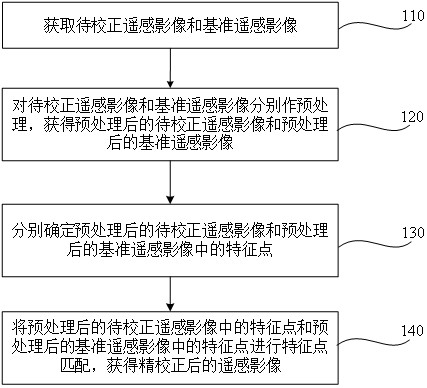
[0030] The technical solutions in the embodiments of the present application will be described below with reference to the drawings in the embodiments of the present application.
[0031] The technical solutions provided by the embodiments of the present application can be applied to various application scenarios that require precise correction of remote sensing images. The remote sensing images involved can be remote sensing images with different resolutions, different sensors, different shooting angles, and different imaging conditions, namely , the applicable remote sensing images may be multi-source remote sensing images, and the applicable remote sensing images may be high-resolution images or other resolution images.
[0032] For example, in surface observation and analysis, different types of remote sensing images need to be corrected; therefore, this technical solution can be applied to surface observation and analysis to correct remote sensing images.
[0033] Based o...
PUM
 Abstract
Description
Claims
Application Information
 - R&D
- Intellectual Property
- Life Sciences
- Materials
- Tech Scout
- Unparalleled Data Quality
- Higher Quality Content
- 60% Fewer Hallucinations
Browse by: Latest US Patents, China's latest patents, Technical Efficacy Thesaurus, Application Domain, Technology Topic, Popular Technical Reports.
© 2025 PatSnap. All rights reserved.Legal|Privacy policy|Modern Slavery Act Transparency Statement|Sitemap|About US| Contact US: help@patsnap.com