Window sliding GPM data correction method considering spatial distribution

A spatial distribution and window technology, applied in structured data retrieval, geographic information database, special data processing applications, etc., to achieve the effect of reducing correction errors

Active Publication Date: 2022-02-08
CHINA INST OF WATER RESOURCES & HYDROPOWER RES
View PDF17 Cites 0 Cited by
  • Summary
  • Abstract
  • Description
  • Claims
  • Application Information

AI Technical Summary

Benefits of technology

The technical effects are improved precision when analyzing soil moisture content over time due to its spatial location from an on-site measurement device called GPS (Global Position System). This allows us to predict future water levels based on these measurements accurately without any errors caused during analysis or simulations. Additionally, it provides more precise geographic coordinates than previously possible because we only measure the distance covered while drilling through the area instead of measuring directly at specific points within each section.

Problems solved by technology

This patented technical problem addressed by this patents relates to improving the efficiency at which satellites collect rainwater samples are analyzed during their observation period (their ability to accurately measure rainfall) while also considering variations between different locations within each sample due to its location or movement over time. Current solutions such as averaging error corrections based on mean values have limited effectiveness when dealing with small changes in space distributions and timescales associated with precipitations.

Method used


Image

  • Window sliding GPM data correction method considering spatial distribution
  • Window sliding GPM data correction method considering spatial distribution
  • Window sliding GPM data correction method considering spatial distribution

Examples


Embodiment 1

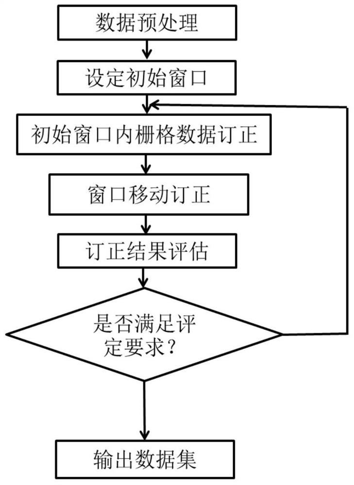
[0037] Such as figure 1 As shown, in this embodiment, a kind of window sliding GPM data correction method considering spatial distribution is provided, comprising the following steps,

[0038] S1. Preprocessing satellite raster data and ground station data;

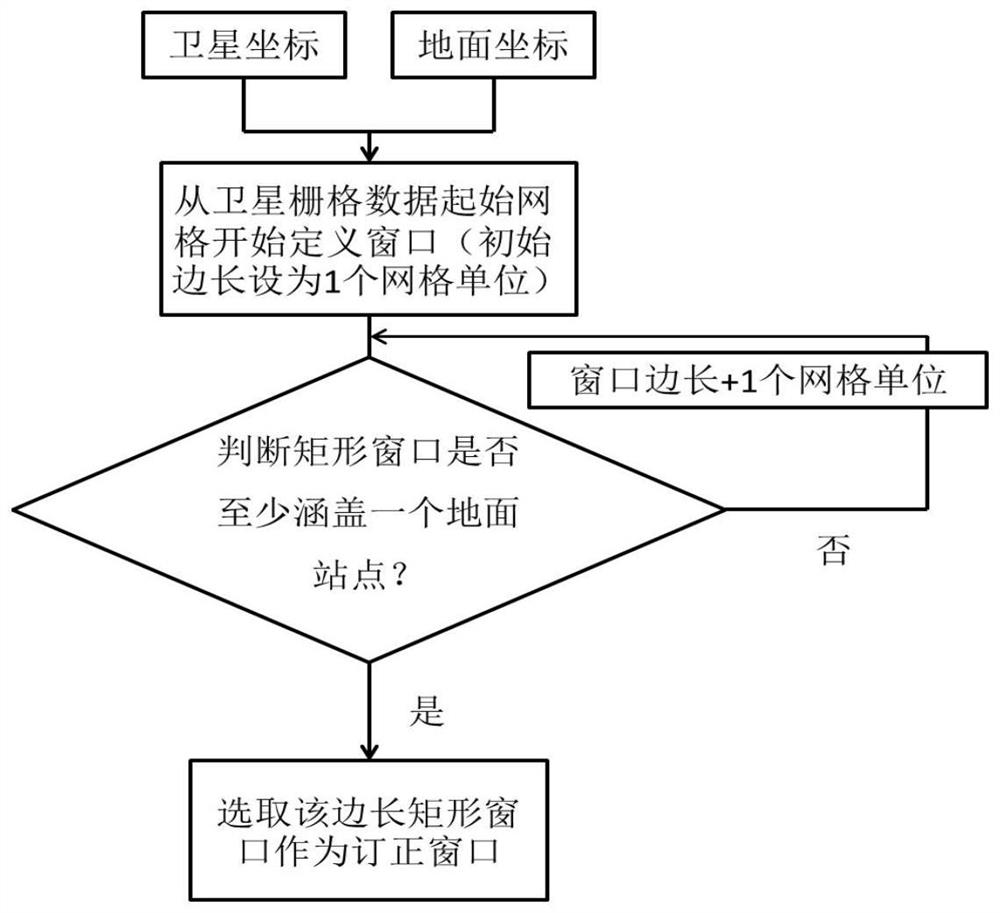
[0039] S2. According to the preprocessed satellite raster data and ground station data, an initial window is set;

[0040] S3. Correcting the satellite grid data in the initial window, moving the initial window to correct all the satellite grid data in turn;

[0041] S4. Evaluate the correction result.

[0042] In this embodiment, the correction method mainly includes four parts, which are data preprocessing, initial window setting, satellite raster data correction, and correction result evaluation. The following four parts are described in detail respectively.

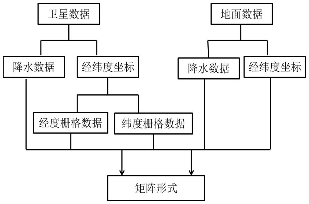
[0043] 1. Data preprocessing

[0044] This part corresponds to step S1, and step S1 specifically includes the following content, see figure 2 ,

[0045] P...

Embodiment 2

[0103] In this embodiment, the Northwest region (the longitude range is 73 degrees east longitude to 123 degrees east longitude, and the latitude range is 37 degrees north latitude to 50 degrees north latitude) is used as the research area of ​​the embodiment, and the ground observation site data is used to correct the satellite raster data (GPMIMERG Final Run), illustrates the effectiveness of the present invention.

[0104] A total of 178 ground observation stations in Northwest China were used in the study, and their spatial distribution is as follows: Figure 6 shown. First, use the measured precipitation data of 128 ground stations to correct and train the satellite raster data in July 2018 to obtain the corrected raster data, and then use the measured data of the remaining 50 ground observation stations to verify and evaluate the correction results , the results are shown in Table 1. Contour maps are drawn for the results in Table 1, as shown in Figure 7, (a) is the con...


PUM


Abstract

The invention discloses a window sliding GPM data correction method considering spatial distribution. The method comprises the following steps of S1, carrying out preprocessing of satellite raster data and ground station data; S2, setting an initial window according to the preprocessed satellite raster data and ground station data; S3, correcting the satellite raster data in the initial window, and moving the initial window to correct all the satellite raster data in sequence; and S4, evaluating the correction result. The method is advantaged in that space-time distribution characteristics of satellite rainfall data can be considered, ground station actually measured rainfall data are used as reference, satellite grid data are locally corrected, correction errors are reduced, and correction results have relatively high precision.

Description


Claims


Application Information

Patent Timeline
Owner CHINA INST OF WATER RESOURCES & HYDROPOWER RES
Why Eureka
Try Eureka