Method for calculating cloud base height by using meteorological satellite data

A technology for meteorological satellites and cloud base heights, applied in computing, meteorology, computer parts, etc., can solve the problems of low computing efficiency, product accuracy depends on selection accuracy, etc., achieve high computing efficiency, reduce the loss of people's lives and property, and realize The effect of real-time calculation

Pending Publication Date: 2022-03-01
NAT SATELLITE METEOROLOGICAL CENT
View PDF0 Cites 1 Cited by
  • Summary
  • Abstract
  • Description
  • Claims
  • Application Information

AI Technical Summary

Problems solved by technology

Using the method of neural network or support vector basis, the product accuracy depends on the selection accuracy of the database, and the calculation efficiency is low

Method used


Image

  • Method for calculating cloud base height by using meteorological satellite data
  • Method for calculating cloud base height by using meteorological satellite data
  • Method for calculating cloud base height by using meteorological satellite data

Examples


Embodiment Construction

[0051] The following will clearly and completely describe the technical solutions in the embodiments of the present invention with reference to the accompanying drawings in the embodiments of the present invention. Obviously, the described embodiments are only some, not all, embodiments of the present invention. All other embodiments obtained by persons of ordinary skill in the art based on the embodiments of the present invention belong to the protection scope of the present invention.

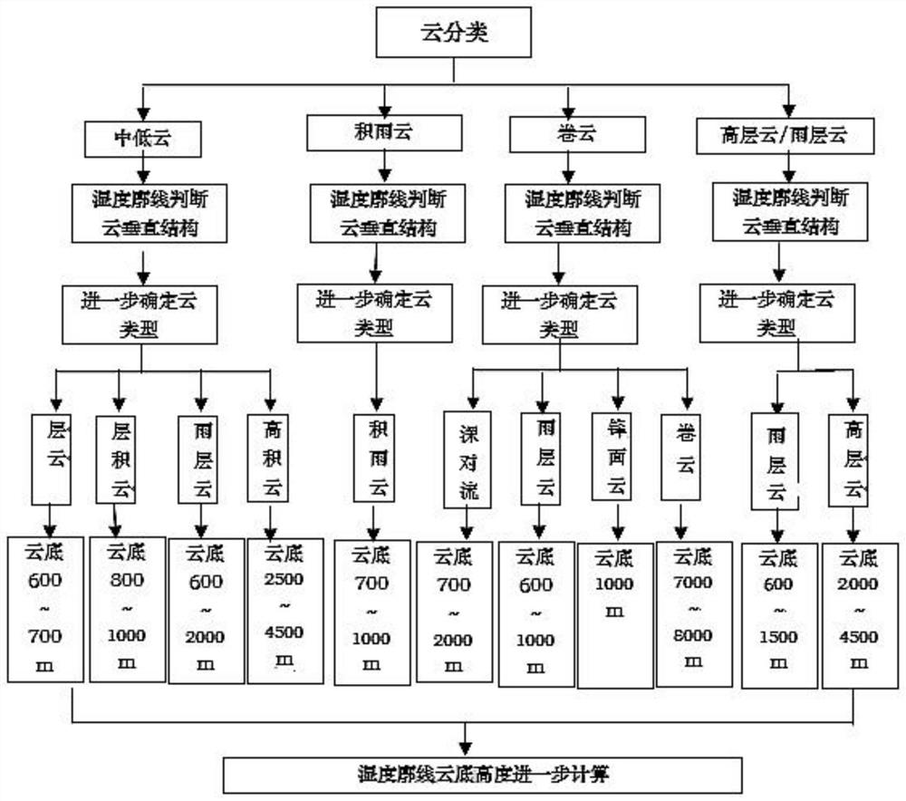
[0052] Such as figure 1 As shown, according to the method for calculating cloud base height using meteorological satellite data described in the embodiments of the present invention, the method calculates cloud base height based on Fengyun No. 2 meteorological satellite cloud area humidity profile and cloud classification, including the following steps:

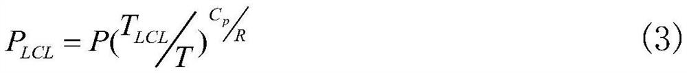
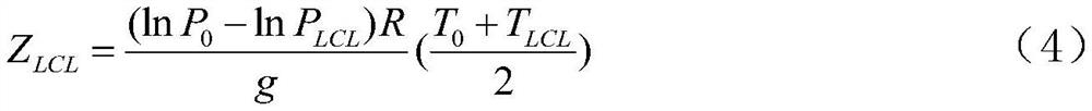
[0053] S1 Obtain FY-2 satellite cloud area humidity profile products and cloud classification products, perform time and space point-to-poi...


PUM


Abstract

The invention discloses a method for calculating the height of a cloud base by using meteorological satellite data, and the method comprises the steps: obtaining an FY-2 satellite cloud region humidity profile product and a cloud classification product, carrying out the time and space matching of the FY-2 satellite cloud region humidity profile data, the cloud classification data and earth surface type data, and obtaining two registered products and earth surface type data; performing statistics to establish cloud base height characteristic value models of different cloud types and different cloud region humidity profiles; and establishing a calculation model of different cloud classifications and cloud region humidity profiles, analyzing to obtain a vertical structure and cloud classes of the cloud, and comprehensively estimating the cloud base height according to cloud base height feature values of different cloud classes and vertical structure features of the cloud. According to the method for calculating the cloud base height by using the meteorological satellite data, the real-time calculation of the cloud base height can be realized, the 15-minute time frequency, the 5-kilometer spatial resolution and the full-coverage cloud base height can be obtained, the calculation efficiency is high, and the real-time calculation can be realized in a place with a data environment.

Description

technical field [0001] The invention relates to the technical field of cloud base height calculation by meteorological satellites, in particular to a method for calculating cloud base height using meteorological satellite data. Background technique [0002] The height of cloud base is a very important parameter in meteorology. It has always been mainly observed by human eyes. Human eye observation is relatively subjective, resulting in great uncertainty in the data, and the number and distribution of observations are very limited. In recent years, China Start to deploy some ceilometers, and you can also get observations of the cloud base, but the same base stations are scattered data, which cannot be covered in many places. In order to obtain cloud base height data with higher spatial and spatial resolution, people also use meteorological factor diagnosis and calculation methods to obtain cloud base height. The main methods include: [0003] (1) MOS method, that is, the pos...

Claims


Application Information

Patent Timeline
Patent Type & Authority Applications(China)
IPC IPC(8): G01C5/00G01W1/10G06F30/27G06K9/62
CPCG01C5/00G01W1/10G06F30/27G06F18/24Y02A90/10
Inventor 覃丹宇刘瑞霞吴晓惠雯杨冰韵王富
Owner NAT SATELLITE METEOROLOGICAL CENT
Why Eureka
Try Eureka