Automatic roadside tree extraction method based on geographical national condition data and image classification

An image classification and automatic extraction technology, applied in character and pattern recognition, instruments, computer parts, etc., can solve problems such as loss of effective information and data, less consideration and low efficiency in remote sensing image band selection methods, and reduce computing power. Cost, effect of reducing statistics time and information extraction time

Active Publication Date: 2022-03-11
CHINESE ACAD OF SURVEYING & MAPPING
View PDF2 Cites 1 Cited by
  • Summary
  • Abstract
  • Description
  • Claims
  • Application Information

AI Technical Summary

Problems solved by technology

[0005] 1. Less consideration is given to the selection method of remote sensing image bands, and there are problems of losing effective information and data redundancy
[0006] 2. In the calculation of

Method used


Image

  • Automatic roadside tree extraction method based on geographical national condition data and image classification
  • Automatic roadside tree extraction method based on geographical national condition data and image classification
  • Automatic roadside tree extraction method based on geographical national condition data and image classification

Examples


Embodiment Construction

[0071] The present invention will be further described in detail below in conjunction with the accompanying drawings.

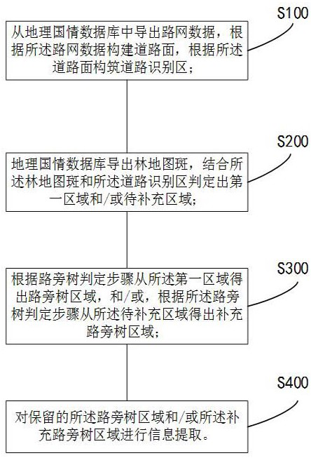
[0072] The method for automatic extraction of roadside trees based on geographic national conditions data and image classification includes the following steps:

[0073] S100: Exporting road network data from the geographic national conditions database, constructing a road surface according to the road network data, and constructing a road identification area according to the road surface;

[0074] Export road network data from LRDL and LCTL layers of geographic national conditions data, and obtain road centerline and road width information;

[0075] Build the road surface:

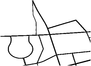
[0076] When constructing the road surface, take the centerline of the road as the central axis and 1 / 2 of the road width as the radius, and extend along the centerline of the road to construct the road surface. The construction results are shown in Figure 2;

[0077] When exporting roa...


PUM


Abstract

The invention discloses a roadside tree automatic extraction method based on geographic national condition data and image classification, and the method is characterized in that the method comprises the following steps: exporting road network data from a geographic national condition database, constructing a road surface according to the road network data, and constructing a road recognition region according to the road surface; the geographic national condition database derives forest map spots, and the forest map spots and the road recognition area are combined to determine a first area and/or a to-be-supplemented area; obtaining a roadside tree area from the first area according to the roadside tree judgment step, and/or obtaining a supplementary roadside tree area from the to-be-supplemented area according to the roadside tree judgment step; performing information extraction on the reserved roadside tree area and/or the supplementary roadside tree area; the method has the advantages that the situations of effective information loss and data redundancy are prevented, the roadside tree area can be rapidly extracted in forest coverage rate calculation through combination of geographic national condition data and various images, the statistical time and the information extraction time are shortened, and the calculation cost is reduced.

Description

technical field [0001] The invention belongs to the field of remote sensing image data processing and information extraction, and in particular relates to an automatic extraction method for roadside trees based on geographic national conditions data and image classification. Background technique [0002] Side trees (also known as roadside trees) refer to all kinds of bamboo and wood planted in houses, villages, roads, water systems, etc. with an area of ​​less than 0.067 hectares. As an important part of forest coverage and forest area, surrounding trees can not only increase forest carbon sequestration and develop a low-carbon economy, but also ensure the healthy development of forest resources and enhance the potential of carbon sinks. They play an important role in environmental regulation. and social service functions. And with the increase of urban area and population density, Bush and DzifaAdimle Puplampu and others believe that urban green space composed of trees all...

Claims


Application Information

Patent Timeline
IPC IPC(8): G06V10/46G06V10/764G06K9/62
CPCG06F18/24
Inventor 董春于浩洋刘纪平栗斌杨振
Owner CHINESE ACAD OF SURVEYING & MAPPING
Why Eureka
Try Eureka