Method for generating simulation airborne fire control radar SAR image based on DEM data

An airborne fire control and data generation technology, applied in image data processing, graphic image conversion, instruments, etc., can solve the problems of multiple computing resources, inability to solve the DEM base map, low efficiency, etc., achieving less computing resources, simulation simulation Good effect and high efficiency

Active Publication Date: 2022-04-12
南京雷电信息技术有限公司
View PDF10 Cites 2 Cited by
  • Summary
  • Abstract
  • Description
  • Claims
  • Application Information

AI Technical Summary

Problems solved by technology

The general SAR image simulation has the following problems: First, it focuses on the simulation of the scene of the front-view SAR image, and does not involve the airborne fire control radar squint SAR image simulation; the second is that the SAR image simulation is only for the designated small-scale area. , it cannot solve the problem of imaging in a large geographical area (such as East Asia) and in a large and wide range during ground flight simulation; the third is that it cannot solve the problem of a DEM base map in tiff format, supporting different resolutions and imaging at different locations; It requires more computing resources, the efficiency is not high, and some require a dedicated DSP chip processor

Method used


Image

  • Method for generating simulation airborne fire control radar SAR image based on DEM data
  • Method for generating simulation airborne fire control radar SAR image based on DEM data
  • Method for generating simulation airborne fire control radar SAR image based on DEM data

Examples


Embodiment Construction

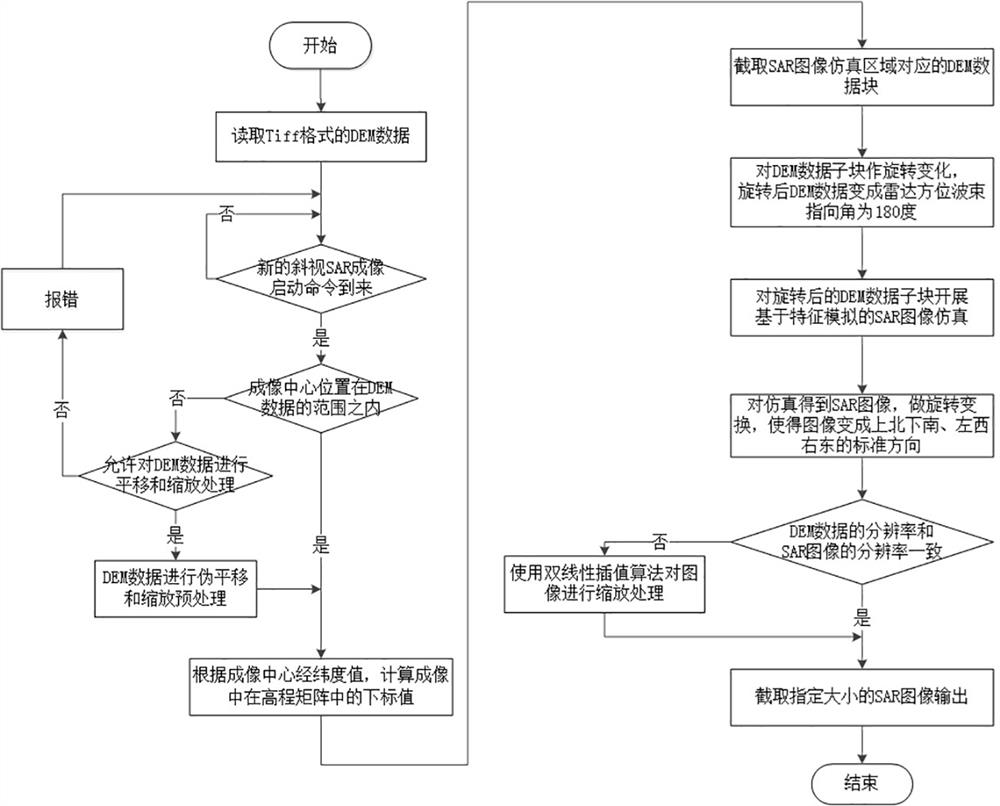
[0062] The technical solutions of the present invention will be described in detail below with reference to the accompanying drawings, but the protection scope of the present invention is not limited to the embodiments.

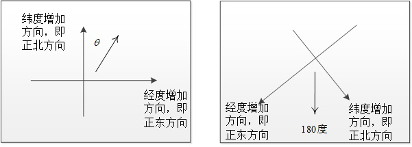
[0063] The present invention realizes the imaging processing of any designated position (that is, the central position of imaging, from the avionics system) within a large geographical area by performing pseudo-translation and zoom processing on the DEM data in tiff format. The data is rotated, and after rotation, it becomes a unified image with the azimuth beam pointing at 180 degrees. After that, the characteristics of the SAR image are simulated, and the simulated SAR image is obtained by relying on the image geometric model and radiation model.

[0064] like figure 1 The shown method for generating a simulated airborne fire control radar SAR image based on DEM data comprises the following steps:

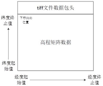
[0065] S1: Perform pseudo-translation and zoom preprocess...


PUM


Abstract

The invention discloses a method for generating a simulation airborne fire control radar SAR image based on DEM data, and the method comprises the steps: reading the DEM data in a tiff format, and determining that the position of an imaging center is within a DEM data range; calculating a subscript value of the imaging center in the DEM data elevation matrix according to the longitude and latitude values of the imaging center; corresponding DEM data sub-blocks used for SAR imaging simulation are intercepted; performing rotation change on the DEM data sub-block, wherein the radar azimuth beam directional angle of the rotated DEM data sub-block is 180 degrees; sAR image simulation based on feature simulation is carried out on the rotated DEM data sub-blocks; performing rotation change on the SAR image obtained by simulation to enable the image to be in a standard direction; and intercepting an SAR image with a specified size and outputting the SAR image. According to the method, the real-time SAR imaging simulation requirement of the airborne fire control radar with the observation area reaching thousands of kilometers can be quickly met in real time by using fewer computing resources.

Description

technical field [0001] The invention relates to the technical field of synthetic aperture radar simulation, in particular to a method for generating a simulated airborne fire control radar SAR image based on DEM data. Background technique [0002] Synthetic Aperture Radar (SAR) imaging has the advantages of all-day, all-weather, and penetrability. It can obtain high-resolution radar images of targets in different frequency bands and different polarizations, providing people with very useful Target information has been widely used in many fields such as economy and technology, and has broad application prospects and development potential. [0003] The real SAR image can only be obtained by carrying out a flight test in the sky with an imaging radar on an aircraft, and the cost of the flight test is very high. Obtaining SAR images by means of simulation, carrying out flight training for pilots and verifying the use of SAR images can greatly reduce training costs and test time...

Claims


Application Information

Patent Timeline
Patent Type & Authority Applications(China)
IPC IPC(8): G06T3/60G01S7/40
Inventor 柯树林马志强冷盛林郑云
Owner 南京雷电信息技术有限公司
Why Eureka
Try Eureka