Landform map construction method convenient for efficient navigation of autonomous mobile robot

A technology for mobile robots and autonomous movement, applied in navigation, surveying and navigation, road network navigators, etc., can solve problems such as inaccurate and unreasonable path planning, high consumption of mobile robots, and neglect of landform costs, etc., to improve the speed of landform segmentation , enhance the extraction ability, and reduce the effect of parameters

Pending Publication Date: 2022-04-12
HANGZHOU DIANZI UNIV
View PDF0 Cites 0 Cited by
  • Summary
  • Abstract
  • Description
  • Claims
  • Application Information

AI Technical Summary

Problems solved by technology

[0004] The purpose of the present invention is to solve the problem that the traditional terrain recognition algorithm is difficult to provide specific passable terrain information, and the traditional navigation algorithm ignores the landscape cost (traditional navigation algorithm does not include different traffic costs contained in different landscapes into the calculation of path planning), resulting in inaccurate path planning. Accuracy is unreasonable, which causes high consumption or high risk of mobile robots, and a method for constructing terrain maps for efficient navigation of autonomous mobile robots is proposed.

Method used


Image

  • Landform map construction method convenient for efficient navigation of autonomous mobile robot
  • Landform map construction method convenient for efficient navigation of autonomous mobile robot
  • Landform map construction method convenient for efficient navigation of autonomous mobile robot

Examples


Embodiment Construction

[0041] The following will clearly and completely describe the technical solutions in the embodiments of the present invention with reference to the accompanying drawings in the embodiments of the present invention. Obviously, the described embodiments are only some, not all, embodiments of the present invention. Based on the embodiments of the present invention, all other embodiments obtained by persons of ordinary skill in the art without making creative efforts belong to the protection scope of the present invention.

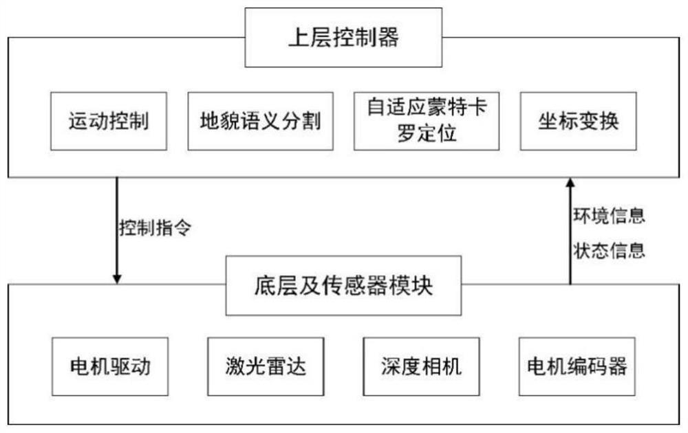
[0042] This implementation plan uses Scout Mini robot, Jetson AGX Xavier small workstation, RPLiDARA3 lidar and RealSense D435 depth camera to build an experimental platform, such as figure 1 shown. A method for constructing a landform map that is convenient for efficient navigation of an autonomous mobile robot, comprising the following specific implementation steps:

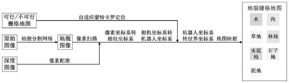
[0043] Step 1: Use depthwise separable convolution to build the encoding path of the landf...


PUM


Abstract

The invention relates to a landform map construction method convenient for efficient navigation of an autonomous mobile robot. The method comprises the following steps: constructing a landform segmentation network: constructing a high-precision lightweight semantic segmentation network by using a depth separable convolution and pyramid pooling module; according to physical and geometric properties of different landforms, the passable landforms are divided and labeled in more detail, and a landform data set is constructed in a targeted manner for model training; and constructing a landform map: constructing a mapping relationship between the landform image and the occupied grid map according to a geometric transformation relationship between the original image acquired by the sensor and the grid map, and creating the landform grid map. According to the method, the landform in the working environment of the mobile robot is divided more meticulously by using the semantic segmentation network, and the landform grid map containing rich information is created through pixel point scanning, coordinate conversion and grid mapping, so that the navigation efficiency of the mobile robot is improved.

Description

technical field [0001] The invention relates to a method for constructing a landform map that is convenient for efficient navigation of an autonomous mobile robot, and belongs to the technical field of robot perception and mapping. Background technique [0002] The identification of passable areas is crucial to the navigation and path planning of mobile robots. At present, most terrain recognition algorithms only divide passable areas and impassable areas. However, more and more mobile robots are working in unstructured or semi-structured environments, which contain a variety of traversable landforms, and there are great differences among the various traversable landforms, such as: concrete, grass, Mud, gravel, etc. When the robot traverses different passable landforms, its safety, passage time and energy consumption are different. [0003] When humans pass through different landforms, they will choose the route with the lowest consumption according to their goals. Mobile...

Claims


Application Information

Patent Timeline
Patent Type & Authority Applications(China)
IPC IPC(8): G06T17/05G06N3/04G06N3/08G01C21/00G01C21/32G01C22/00G01S17/89
Inventor 张波涛洪涛王添吕强
Owner HANGZHOU DIANZI UNIV
Why Eureka
Try Eureka