Positioning map data encryption sending method and system based on multi-parameter dynamic adjustment encryption matrix of user request

A user-requested and dynamically adjusted technology, applied in image data processing, location-based services, and services based on specific environments, etc., can solve problems such as inability to know, the application time cannot be determined, and time parameters have not been added, so as to reduce encryption. The amount of calculation, the effect of improving the anti-reverse solution performance, and increasing the number of parameters

Active Publication Date: 2022-04-22
TERRA DIGITAL CREATING SCI & TECH (BEIJING) CO LTD
View PDF11 Cites 0 Cited by
  • Summary
  • Abstract
  • Description
  • Claims
  • Application Information

AI Technical Summary

Problems solved by technology

[0004]However, the digital map is related to time, and the user's certain spatial position on the map is not fixed, so if the time parameter can be added to the encryption algorithm, it can Even for users at the same location, since the application time cannot be determined, even if the cracker starts from the spatial location, he cannot crack the key because he cannot know the exact user application time.
What's more, the same user may apply for multiple digital map display requests at multiple time points, such as users in motion, such as driving, so it is even more impossible to know which time point the application was made during the motion, which is bound to further Increase the difficulty of cracking
The existing technology has not designed well how to add the time parameter to the map encryption algorithm

Method used


Image

  • Positioning map data encryption sending method and system based on multi-parameter dynamic adjustment encryption matrix of user request
  • Positioning map data encryption sending method and system based on multi-parameter dynamic adjustment encryption matrix of user request
  • Positioning map data encryption sending method and system based on multi-parameter dynamic adjustment encryption matrix of user request

Examples


Embodiment 1

[0079] S1 specifically includes:

[0080] S1-1 collects urban oblique photography data.

[0081] Urban oblique photography data can be collected by using oblique cameras equipped with drones as a flight platform. By applying oblique photography technology, multiple high-resolution images of different angles at the same location can be obtained at the same time. Location information, in which the same specific object can be imaged on multiple images of different angles at different exposure points. When collecting urban oblique image data, data such as plane position, aerial height, geodetic height, flight attitude, and plane position need to be obtained at the same time. .

[0082] S1-2 performs preprocessing on the oblique photographic data to obtain a three-dimensional digital map of the city corresponding to the oblique photographic model of the city.

[0083] After the urban oblique photography data is collected, the oblique photography data can be preprocessed. Specific...

Embodiment 2

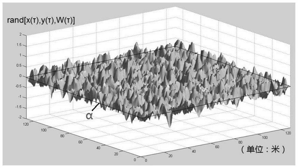
[0087] Continue with Embodiment 1 to implement this embodiment, S2-1 sets W(τ)=r(τ)·w(τ), the multi-parameter dynamic random number generation algorithm rand[x(τ), y(τ), W( τ)]=rand[x(τ),y(τ),r(τ)·w(τ)]∈(-1,1), where x(τ), y(τ) are the user’s request at time τ is the geographic location coordinates of the projection of the three-dimensional digital map on the smooth surface under E, w(τ) is a preset parameter, and the random number is related to x(τ), y(τ), w(τ). For Given time τ, given w(τ) value, and x(τ), y(τ), the generated random values ​​are the same, r(τ) is a random number generation function that changes with time τ, and r(τ ) ∈ (-1,1), try τ denoted as 2021.0226152600. In the following formulas, the time parameter is omitted to indicate 2021.0226152600, so as to make the writing concise, and the actual expression is the expression of τ=2021.0226152600 at a given moment.

[0088] The rectangular area R of city A, the location requested by the user corresponds to i...

Embodiment 3

[0094] Continuing with Embodiment 2, this embodiment S3 specifically includes:

[0095] S3-1 compares the three-dimensional digital map produced in Example 1 and the user's positioning coordinates [x ap (τ),y ap (τ)] on the projection of the smooth surface, that is, the datum plane itself is encrypted,

[0096] S3-2 will and Superimpose to obtain first-level encrypted data , then the offset matrix And at this time the coordinate system E becomes E (1) ;

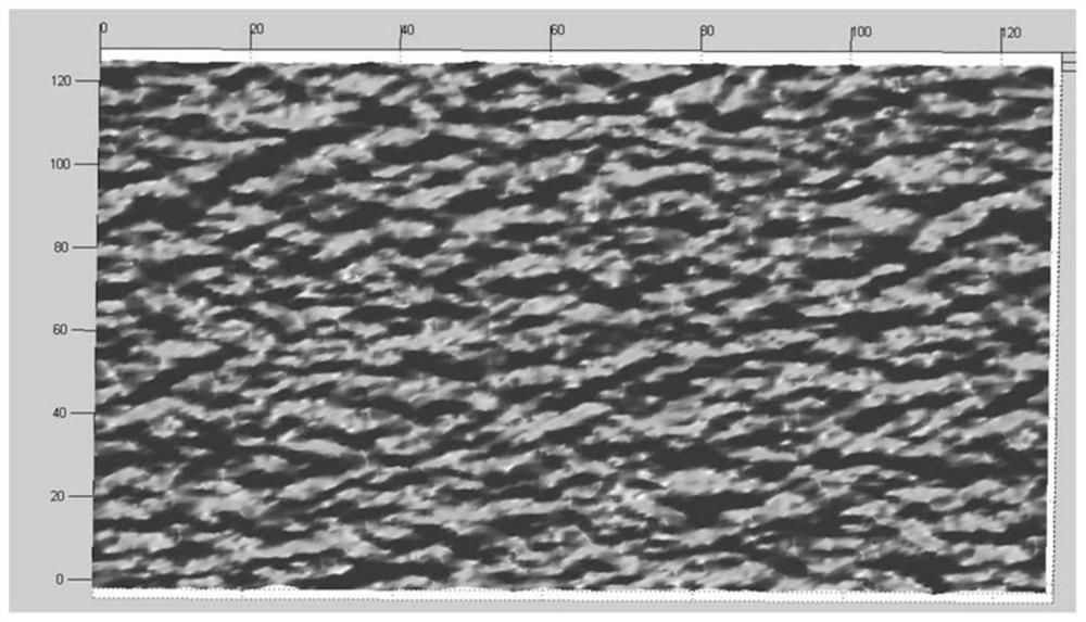
[0097] S3-3 as figure 2 The three-dimensional digital map before encryption (represented by a black box) is translated together with the coordinate system E so that E and E (1) Superimpose and delete the data on the first-level encrypted smooth surface to form a first-level encrypted three-dimensional digital map M 1 .

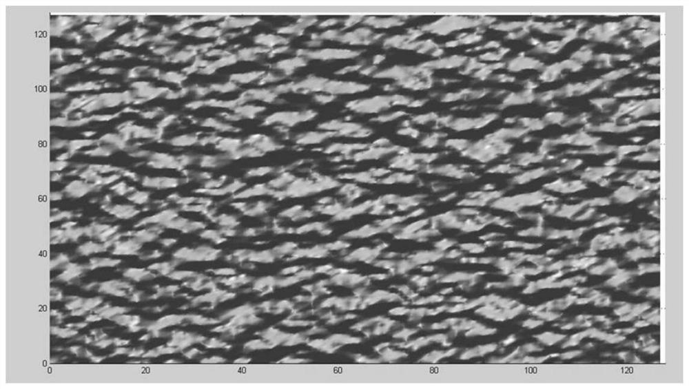
[0098] S4 specifically includes:

[0099] S4-1 utilizes the offset matrix M s to the first level encrypted data J 1 Generate secondary encrypted data after secondary encryption , and the...


PUM


Abstract

The invention provides a positioning map data encryption sending method and system based on a multi-parameter dynamic adjustment encryption matrix of a user request. The method comprises the following steps: determining a reference plane of an original point of a coordinate system of the urban three-dimensional digital map and a smooth surface of which the projection on the reference plane completely covers the reference plane, and dividing the reference plane into a plurality of areas; setting a multi-parameter dynamic random number generation algorithm, and generating an encryption matrix based on the algorithm; using the encryption matrix to encrypt the projection of the three-dimensional digital map and the positioning coordinate of the user on the reference plane to form first-level encryption data, and forming an offset matrix; and performing second-level encryption on the first-level encrypted data by using the offset matrix, generating a second-level encrypted map, and returning the second-level encrypted map to the user for display. According to the scheme provided by the invention, data encryption based on the smooth surface is considered at the same time, the smooth surface is further divided into regions, and a small amount of derivative calculation in X and Y directions is only performed on the formed boundary, so that the encryption calculation amount of the three-dimensional digital map is greatly reduced.

Description

technical field [0001] The invention relates to an encryption method for encrypted matrix price list map data, in particular to a method and a system for encrypting and sending positioning map data based on the multi-parameter dynamic adjustment of the encryption matrix requested by the user. Background technique [0002] The matrix encryption algorithm in the prior art is mainly constructed based on digital or plaintext information, and generally has a decryption algorithm, so on the one hand, it is impossible to truly achieve high anti-reverse solution performance. On the other hand, for the encryption of 3D model maps in 3D space, since the encryption is bound to extend to 3D matrices, the amount of computational data is huge, causing users to generate huge encrypted computing loads when requesting digital maps at different 3D space locations. However, if the three-dimensional properties of the map are considered, it is considered that as long as any request is regarded a...

Claims


Application Information

Patent Timeline
Patent Type & Authority Applications(China)
IPC IPC(8): H04W4/02H04W4/021H04W4/44H04W12/03H04N5/76G06T17/05
CPCH04W4/021H04W4/025H04W4/44H04W12/03H04N5/76G06T17/05G06T2200/08
Inventor 刘俊伟彭贵堂
Owner TERRA DIGITAL CREATING SCI & TECH (BEIJING) CO LTD
Why Eureka
Try Eureka