Depth reference frame point laying method for coastal sea area of China

A technology of depth and sea area, applied in the field of graphic expression of the effective range of linear interpolation of reference frame points, can solve problems such as model accuracy reduction

Pending Publication Date: 2022-05-17
PLA DALIAN NAVAL ACADEMY
View PDF0 Cites 1 Cited by
  • Summary
  • Abstract
  • Description
  • Claims
  • Application Information

AI Technical Summary

Problems solved by technology

In recent years, the construction of high-precision tidal models along China's coast has provided a good data basis for the establishment of chart depth reference models. However, in coastal waters, tidal waves are more significantly affected by the shape of the coast and seabed topography, and the accura...

Method used


Image

  • Depth reference frame point laying method for coastal sea area of China
  • Depth reference frame point laying method for coastal sea area of China
  • Depth reference frame point laying method for coastal sea area of China

Examples


Embodiment Construction

[0057] In order to make the method scheme adopted by the present invention and the effect achieved more clearly, the present invention will be further described in detail below in conjunction with the accompanying drawings and experiments. It can be understood that the specific experiments described here are only used to explain the present invention, not to limit the present invention. In addition, it should be noted that, for the convenience of description, only parts related to the present invention are shown in the drawings but not all content.

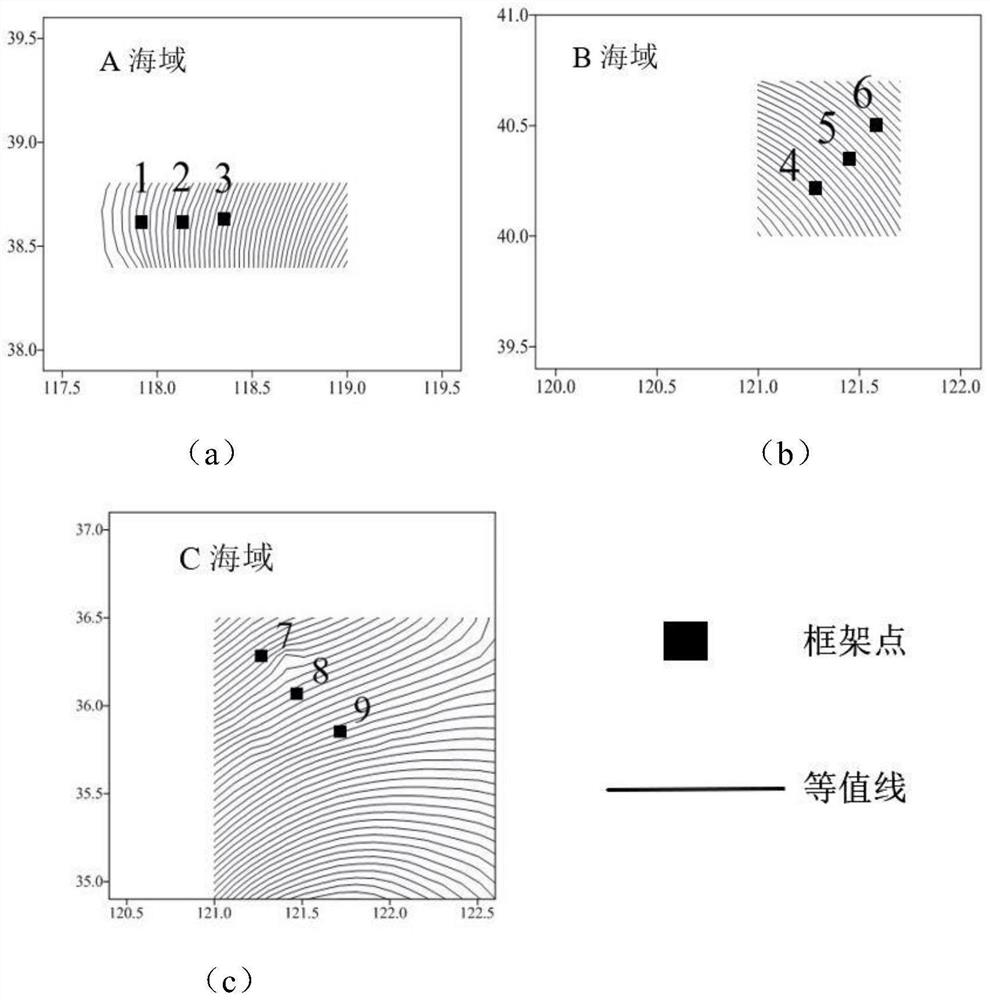
[0058] In order to study the effective range of the linear interpolation of the frame point depth datum, based on the high-precision depth datum model, a total of 9 frame points were selected in the A sea area, the B sea area and the C sea area. The points are as follows: figure 2 shown. The black points 1-9 in the figure represent the 9 selected frame points. Points 1-3 and points 4-6 are located in sea area A and sea area B re...


PUM


Abstract

The invention discloses a Chinese coastal sea area depth reference frame point layout method, and belongs to the field of depth reference precision control research. According to the method, on the basis of a nautical chart depth datum plane model, the nonlinear change degree of the nautical chart depth datum plane in different directions is researched by using a second derivative, and the tolerance requirement of the nautical chart depth datum plane model error and a mathematical model of the datum plane maximum interpolable distance in different directions are deduced. According to the method, a tolerance index of datum plane interpolation is given by combining a tolerance index of water depth measurement in Sea Channel Measurement Standards (GB12327-1998), an effective range of datum plane linear interpolation is determined, graphic expression of the effective range is realized, on one hand, research results can provide a theoretical basis for layout of frame points in coastal sea areas in China, and on the other hand, the research results can provide a theoretical basis for layout of frame points in coastal sea areas in China; a means is provided for rationality evaluation of frame point positions; on the other hand, arrangement of a tide station can be assisted, and water level reduction precision is improved.

Description

technical field [0001] The invention belongs to the research field of depth reference accuracy control, in particular to the graphic expression of the effective range of linear interpolation of reference frame points. Background technique [0002] The depth datum of the chart is the starting surface of the water depth on the map. It is an ideal surface defined to ensure the safety of the ship's navigation. Whether it is accurate or not will directly affect the accuracy of the water depth on the map. On the one hand, the 13 tidal points used in the calculation of the depth datum need to be obtained through long-term tide data, and the distribution of tide gauge stations with long-term observation data in my country is relatively discrete, and the depth datum determined from this is also characterized by a discrete distribution. On the other hand, the depth datum is closely related to the nature of the tides. Due to the influence of sea and land distribution, seabed topography ...

Claims


Application Information

Patent Timeline
IPC IPC(8): G06F17/13
CPCG06F17/13
Inventor 金绍华迟亮唐岩黄辰虎崔杨
Owner PLA DALIAN NAVAL ACADEMY
Why Eureka
Try Eureka