Complex heterogeneous navigation constellation implementation method based on low orbit, medium orbit and high orbit

An implementation method and technology for medium and high orbits, which are applied in satellite radio beacon positioning systems, instruments, design optimization/simulation, etc., and can solve the problem of long convergence time for precise single-point positioning, lack of complex heterogeneous navigation constellation implementation methods, and difficulty in meeting navigation requirements. Positioning requirements and other issues to achieve the effect of maintaining navigation and positioning performance

Pending Publication Date: 2022-05-27
PLA PEOPLES LIBERATION ARMY OF CHINA STRATEGIC SUPPORT FORCE AEROSPACE ENG UNIV
View PDF0 Cites 0 Cited by
  • Summary
  • Abstract
  • Description
  • Claims
  • Application Information

AI Technical Summary

Problems solved by technology

[0003] However, the high-orbit navigation satellite constellation also has its inherent defects: (1) The landing signal is weak, and it is difficult to meet the navigation and positioning needs of complex scenes such as dense urban areas, mountainous canyons, indoor and other sheltered environments, and seamless indoor and outdoor connections; (2) The geometric configuration of the satellite’s space on the earth does not change significantly, resulting in a long convergence time for precise point positioning, which affects the efficiency of real-time high-precision positioning operations
[0004] The existing regional navigation constellation is mainly composed of GEO and IGSO satellites, and the global navigation constellation has added MEO satellites. At present, there is still a lack of implementation methods for complex heterogeneous navigation constellations based on low, medium and high orbits to meet the needs of space service domains and navigation warfare.

Method used


Image

  • Complex heterogeneous navigation constellation implementation method based on low orbit, medium orbit and high orbit
  • Complex heterogeneous navigation constellation implementation method based on low orbit, medium orbit and high orbit
  • Complex heterogeneous navigation constellation implementation method based on low orbit, medium orbit and high orbit

Examples


Embodiment Construction

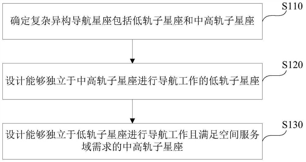
[0042] The technical solutions in the embodiments of the present invention will be clearly and completely described below with reference to the accompanying drawings in the embodiments of the present invention. Obviously, the described embodiments are only a part of the embodiments of the present invention, but not all of the embodiments. The components of the embodiments of the invention generally described and illustrated in the drawings herein may be arranged and designed in a variety of different configurations. Thus, the following detailed description of the embodiments of the invention provided in the accompanying drawings are not intended to limit the scope of the invention as claimed, but are merely representative of selected embodiments of the invention. Based on the embodiments of the present invention, all other embodiments obtained by those skilled in the art without creative work fall within the protection scope of the present invention.

[0043] The regional navi...


PUM


Abstract

The invention provides a complex heterogeneous navigation constellation implementation method based on low-orbit, medium-orbit and high-orbit. The complex heterogeneous navigation constellation is determined to comprise a low-orbit sub-constellation and a medium-orbit and high-orbit sub-constellation; designing a low-orbit sub-constellation capable of performing navigation work independent of the medium-and-high-orbit sub-constellation, determining that the configuration of the low-orbit sub-constellation comprises a low-orbit Walker constellation if the coverage of a south pole and a north pole does not need to be considered, and designing a first variable of the low-orbit Walker constellation; if the coverage of the south pole and the north pole needs to be considered, determining that the configuration of the low-orbit sub-constellation comprises a low-orbit Walker constellation and a polar-orbit constellation, and designing a first variable of the low-orbit Walker constellation and a second variable of the polar-orbit constellation; according to the method, a low-orbit sub-constellation and a middle-orbit sub-constellation which can perform navigation work independently of the low-orbit sub-constellation and meet the requirement of a space service domain are designed, and in the high-orbit sub-constellation and the middle-orbit sub-constellation, satellites are interconnected and intercommunicated by adopting inter-satellite links, so that the high-orbit sub-constellation and the middle-orbit sub-constellation can also work under the condition that part of satellites fail; and the requirements of a space service domain and a navigation battle can be met.

Description

technical field [0001] The invention belongs to the field of complex heterogeneous constellation design, in particular to a method for realizing a complex heterogeneous navigation constellation based on low, medium and high orbits. Background technique [0002] High-orbit navigation (or navigation-enhanced) satellite constellations, which mainly use Medium Earth Orbit (MEO), Geostationary Orbit (GEO) and Inclined Geosynchronous Orbit (IGSO), are the most The scheme adopted by the constellations. The main advantages of the high-orbit navigation satellite constellation are: (1) High altitude, a single satellite has a wide coverage area to the ground, and a small number of satellites can meet the target area coverage and navigation and positioning capabilities; (2) The sub-satellite point in inclined geosynchronous orbit The track has good coverage for a specific area, and the ground is stationary or moving slowly, which can meet the long-term visibility and continuous navigat...

Claims


Application Information

Patent Timeline
Patent Type & Authority Applications(China)
IPC IPC(8): G01S19/38G06F30/20
CPCG01S19/38G06F30/20
Inventor 胡敏阮永井薛文张雅声宿晨庚孟轶男云朝明孙天宇
Owner PLA PEOPLES LIBERATION ARMY OF CHINA STRATEGIC SUPPORT FORCE AEROSPACE ENG UNIV
Why Eureka
Try Eureka