Multi-antenna combined buoy system for satellite altimeter calibration

An altimeter and multi-antenna technology, applied in the field of navigation, can solve the problem of low accuracy of position and attitude measurement, and achieve the effect of ensuring accuracy and reliability

Inactive Publication Date: 2022-06-24
SHANDONG UNIV OF SCI & TECH
View PDF5 Cites 1 Cited by
  • Summary
  • Abstract
  • Description
  • Claims
  • Application Information

AI Technical Summary

Problems solved by technology

[0004] The invention proposes a multi-antenna combined buoy system for satellite altimeter calibration, which solves the prob

Method used


Image

  • Multi-antenna combined buoy system for satellite altimeter calibration
  • Multi-antenna combined buoy system for satellite altimeter calibration
  • Multi-antenna combined buoy system for satellite altimeter calibration

Examples


Embodiment Construction

[0032] The specific embodiments of the present invention will be further described below in conjunction with specific embodiments:

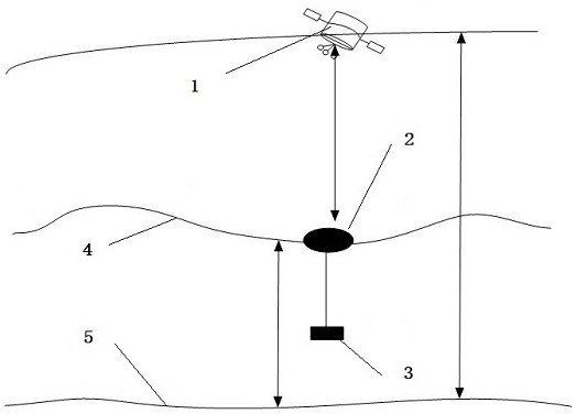
[0033] A multi-antenna GNSS / INS combined buoy body 2 system for satellite altimeter calibration, based on a reference ellipsoid 5, including a buoy body 2, a GNSS receiver, an INS sensor and four GNSS antennas;

[0034] The buoy body 2 includes the buoy body 2, a power supply system, a waterproof and moisture-proof system, and a data processing center. The positioning of the buoy body 2 includes RTK and PPP. The INS sensor measures and outputs the buoy body. 2 high-frequency position, speed and attitude information, the GNSS antenna provides the buoy body 2 high-precision attitude information;

[0035] When the altimetry satellite 1 runs on the sea surface 4 and passes directly above the buoy body 2, the satellite altimeter is calibrated through the satellite altimetry and the accurately measured height of the buoy body 2, such as figure 1 , the...


PUM


Abstract

The invention discloses a multi-antenna combined buoy system for calibrating a satellite altimeter, which belongs to the technical field of navigation, is used for calibrating a maritime satellite altimeter and comprises a buoy, a GNSS (Global Navigation Satellite System) receiver, an INS (Inertial Navigation Satellite System) sensor and four GNSS antennas, the buoy comprises a buoy body, a power supply system, a waterproof and moistureproof system and a data processing center, positioning of the buoy comprises an RTK mode and a PPP mode, the INS sensor measures and outputs high-frequency position, speed and attitude information of the buoy, and the GNSS four-antenna provides high-precision attitude information of the buoy for inclination correction; when the height measurement satellite passes right above the buoy, the satellite altimeter is calibrated through the height measurement of the satellite and the accurate measurement of the height of the buoy.

Description

technical field [0001] The invention discloses a multi-antenna combined buoy system for satellite altimeter calibration, belonging to the technical field of navigation. Background technique [0002] Accurate determination and monitoring of global sea level changes is of great significance to study the impact of oceans on long-term climate change. With the rapid development of satellite altimetry technology, the current measurement accuracy of sea surface height has reached 2-3cm. In addition to Jason-2, the main altimeter satellites currently in orbit are the first radar altimeter satellite HY-2A launched by my country and the Saral altimeter satellite in cooperation with India and France. The simultaneous observation of multiple altimeter satellites can obtain high-precision sea surface elevation, which is of great significance for the study of ocean climate change in global or local sea areas. [0003] After the altimetry satellite has been running for a long time, it is...

Claims


Application Information

Patent Timeline
IPC IPC(8): G01S19/49G01C5/00G01C21/16G01C21/20G01C25/00
CPCG01S19/49G01C5/00G01C21/165G01C21/20G01C25/00
Inventor 张倩然邵虎林刘以旭王胜利周兴华胡亮亮
Owner SHANDONG UNIV OF SCI & TECH
Why Eureka
Try Eureka