
Method for correcting zenith angle simulation error of positive orbit satellite based on optical tracking

A technology of optical tracking and zenith angle, applied in the field of polar orbiting satellites, it can solve the problem that the sounding data does not consider the spatial variation of radiation deviation and air quality factor, etc., to achieve the effect of eliminating the impact

Pending Publication Date: 2022-07-05
NAT SATELLITE METEOROLOGICAL CENT +2
View PDF0 Cites 1 Cited by
  • Summary
  • Abstract
  • Description
  • Claims
  • Application Information

AI Technical Summary

Problems solved by technology

Most of these works study the bias problem by comparing the radiation calculated by the corrected sounding profile. In fact, the sounding data itself also contains bias, and these bias correction methods do not consider the spatial variation of radiation bias and the air quality factor.

Method used


Image

  • Method for correcting zenith angle simulation error of positive orbit satellite based on optical tracking
  • Method for correcting zenith angle simulation error of positive orbit satellite based on optical tracking
  • Method for correcting zenith angle simulation error of positive orbit satellite based on optical tracking

Examples


Embodiment Construction

[0033] In order to make the purposes, technical solutions and advantages of the embodiments of the present invention clearer, the technical solutions in the embodiments of the present invention will be clearly and completely described below with reference to the accompanying drawings in the embodiments of the present invention. Obviously, the described embodiments These are some embodiments of the present invention, but not all of them. Based on the embodiments of the present invention, all other embodiments obtained by those of ordinary skill in the art without creative efforts shall fall within the protection scope of the present invention. Accordingly, the following detailed description of the embodiments of the invention provided in the accompanying drawings is not intended to limit the scope of the invention as claimed, but is merely representative of selected embodiments of the invention. Based on the embodiments of the present invention, all other embodiments obtained b...


PUM


Abstract

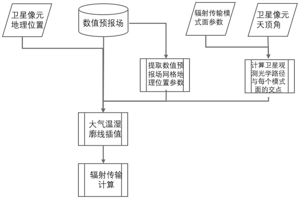
The invention discloses a method for correcting a zenith angle simulation error of a positive orbit satellite based on optical tracking. The method comprises the following steps: firstly, calculating projections of intersection points of a radiation transmission mode layer and a satellite observation optical path on the ground one by one; according to the geographic position of the intersection point, interpolating from the numerical forecasting field grid points to obtain an atmospheric profile of the intersection point position; intercepting and interpolating an atmospheric temperature and humidity profile from the mode surface height of the radiation transmission mode to interpolate a profile of a corresponding height layer; repeating the steps on the radiation transmission mode surfaces one by one from the ground until the top of the atmosphere; and recombining the atmospheric profile between each radiation transmission mode surface into an atmospheric profile of a continuous height from the ground to the atmosphere top according to the corresponding mode surface, and inputting the atmospheric profile into a radiation transmission mode for calculation. According to the invention, deviation calculation is more accurate.

Description

technical field [0001] The invention relates to the technical field of polar-orbiting satellites, in particular to a method for determining a zenith angle simulation error of a polar-orbiting satellite based on optical tracking. Background technique [0002] The polar-orbiting satellite atmospheric detector adopts a cross-orbit scanning method, and each scanning line is perpendicular to the satellite orbit direction. In the assimilation of satellite vertical sounding data, the calculation of satellite simulation observation calculation only needs to select the atmospheric temperature and humidity profile corresponding to the geographic projection location of the satellite pixel. The projected geographic location is the ground projected geographic location of the satellite pixel. Multiply the profile by the satellite zenith angle function of the pixel and then input the radiation transfer mode to calculate the satellite channel brightness temperature. The deviation between th...

Claims


Application Information

Patent Timeline
Patent Type & Authority Applications(China)
IPC IPC(8): G01S19/23
CPCG01S19/23
Inventor 马刚徐娜
Owner NAT SATELLITE METEOROLOGICAL CENT
Learn More