Urban ecological red line early warning method and device based on human activity feedback
A technology for human activities and ecology, applied in data processing applications, instruments, calculations, etc., can solve the problem of misidentification of polluted areas, inaccuracy in judging the ecological conditions of residential areas and cities, and inability to provide strong support for ecological environment improvement work. , to reduce the error rate and improve the accuracy of judgment
- Summary
- Abstract
- Description
- Claims
- Application Information
AI Technical Summary
Problems solved by technology
Method used
Image


Examples
Embodiment 1
[0082] Please refer to figure 1 , is a flowchart of steps of an urban ecological red line early warning method based on human activity feedback provided by the embodiment of the present invention, including steps S1 to S5, and each step is as follows:
[0083] In step S1, a remote sensing image of a target urban area is obtained, and an urban construction planning layout diagram of the target urban area is obtained.
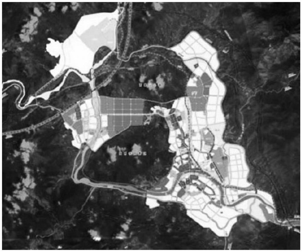
[0084] Specifically, it is first necessary to obtain remote sensing images of the urban area to be studied. Since the construction of buildings in the city is very strict, such as figure 2 As shown, it is a schematic diagram of a remote sensing image of a target urban area in an embodiment of the present invention. The current scale of construction of the target city can be obtained in the urban construction planning layout map.
[0085] Step S2, according to the urban construction planning layout map, divide the planned land area in the remote sensing image, ...
Embodiment 2
[0116] like Figure 4 As shown, it is a schematic structural diagram of an urban ecological red line early warning device based on human activity feedback provided by another embodiment of the present invention, including an image acquisition module, an area division module, an image segmentation module, an image recognition module and an ecological early warning module. The modules are as follows:
[0117] The image acquisition module is used for acquiring remote sensing images of the target urban area, and acquiring the urban construction planning layout map of the target urban area.
[0118] an area division module, configured to divide the planned land area in the remote sensing image according to the urban construction planning layout, wherein the planned land includes an agricultural land area, a construction land area and an unused land area; and, Ecoregions are determined in the unused land area.
[0119] The image segmentation module is used to segment the divided r...
Embodiment 3
[0144] An embodiment of the present invention further provides a computer-readable storage medium, where the computer-readable storage medium includes a stored computer program; wherein, the computer program controls a device where the computer-readable storage medium is located to execute the above-mentioned operation when running. The urban ecological red line early warning method based on human activity feedback according to any one of the embodiments.
PUM
 Abstract
Description
Claims
Application Information
 - R&D
- Intellectual Property
- Life Sciences
- Materials
- Tech Scout
- Unparalleled Data Quality
- Higher Quality Content
- 60% Fewer Hallucinations
Browse by: Latest US Patents, China's latest patents, Technical Efficacy Thesaurus, Application Domain, Technology Topic, Popular Technical Reports.
© 2025 PatSnap. All rights reserved.Legal|Privacy policy|Modern Slavery Act Transparency Statement|Sitemap|About US| Contact US: help@patsnap.com