Satellite image geometric calibration method considering regions with different longitudes and latitudes

A satellite image and geometric calibration technology, applied in the field of satellite remote sensing, can solve problems such as poor applicability, failure to take into account satellite image conditions, and inability to calibrate the variation of solar radiation difference camera parameters, and achieve the effect of high-precision calibration

Pending Publication Date: 2022-08-02
北京市遥感信息研究所
View PDF0 Cites 3 Cited by
  • Summary
  • Abstract
  • Description
  • Claims
  • Application Information

AI Technical Summary

Problems solved by technology

[0004] Because the conventional geometric calibration method mainly adopts the conventional geometric calibration model, the on-orbit geometric calibration is performed using a single-view satellite image of a certain calibration field area, without considering the satellite images at different sun altitudes during the entire return period of the entire satellite, and cannot The change of camera parameters caused by the large difference in solar radiation when imaging at different sun altitudes in the same area within the calibration regression period makes the applicability of the calibration parameters relatively poor for images at different sun altitudes in non-sun-synchronous orbit satellites, which restricts the On-orbit height positioning processing of high-resolution satellite images, so it is urgent to solve the technical problem of on-orbit geometric calibration at different sun altitudes during the return cycle of non-sun-synchronous orbit satellites

Method used


Image

  • Satellite image geometric calibration method considering regions with different longitudes and latitudes
  • Satellite image geometric calibration method considering regions with different longitudes and latitudes
  • Satellite image geometric calibration method considering regions with different longitudes and latitudes

Examples


Embodiment Construction

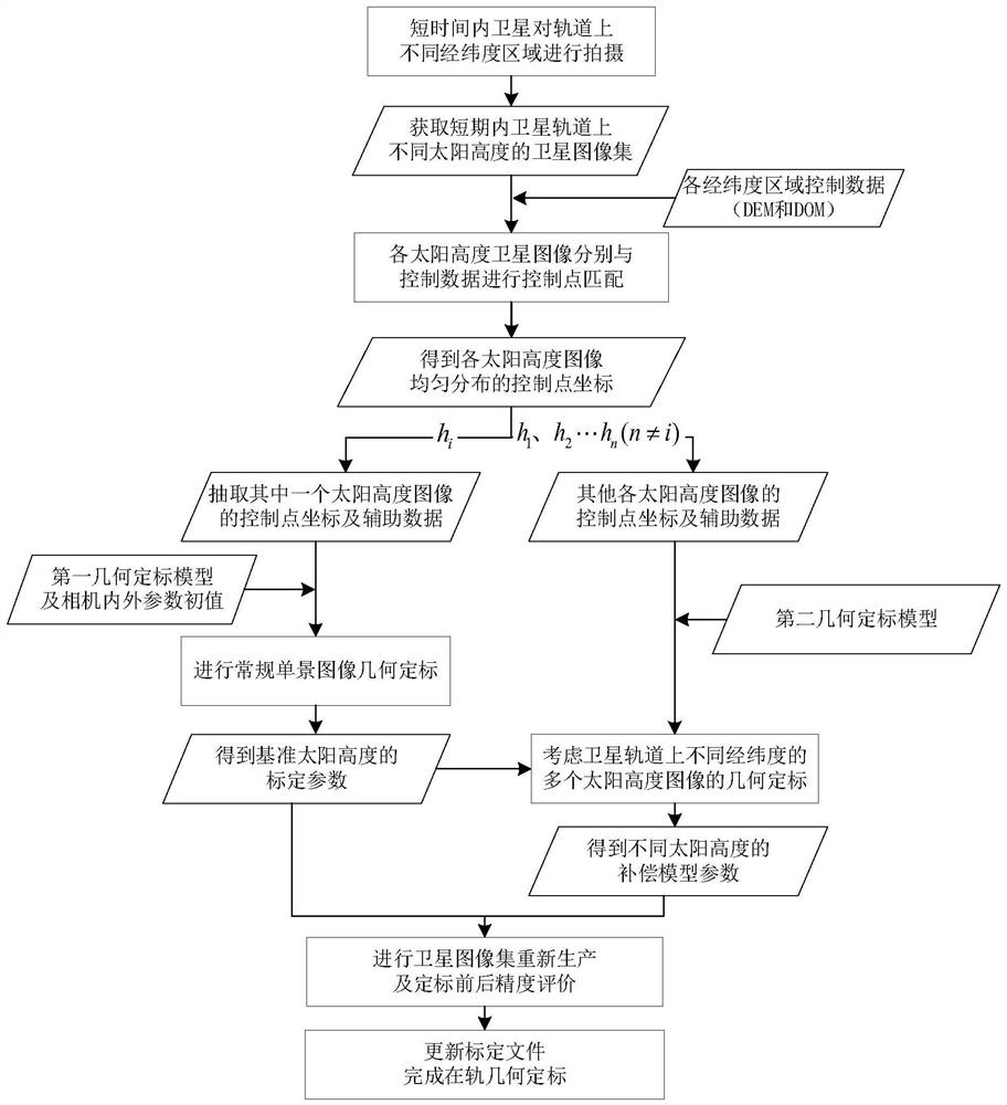
[0057] In order to better understand the content of the present invention, an embodiment is given here.

[0058] like figure 1 As shown, the present invention discloses a method for geometric calibration of satellite images considering different latitude and longitude regions, including:

[0059] S1, acquiring satellite image sets of different latitude and longitude regions in the same orbit of the satellite, and each satellite image in the satellite image set has mutually different sun altitudes;

[0060] S2, the satellite image set obtained in step S1 is matched with the orthophoto and digital elevation model of the corresponding latitude and longitude area respectively, and ground control points are matched, and the ground control points in the satellite image set that are evenly distributed in multiple rows of pixels along the direction of the satellite orbit are obtained. The image coordinate and object coordinate of the control point;

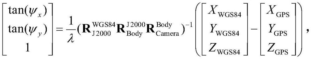
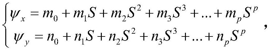
[0061] S3, establish a first geo...


PUM


Abstract

The invention discloses a satellite image geometric calibration method considering different longitude and latitude areas. The method comprises the following steps: acquiring a satellite image set with different sun heights in each longitude and latitude area in the same orbit; acquiring a control point in the satellite image set based on the control data of each longitude and latitude area; selecting a control point in one of the reference sun altitude images, and obtaining camera calibration parameters of the sun altitude based on a first geometric calibration model; constructing attitude error compensation models of different sun altitudes, and establishing a second geometric calibration model considering different latitude and longitude regions; using control points in other sun altitude images to obtain attitude compensation parameters; and updating the calibration file based on a second geometric calibration model according to the camera calibration parameters of the reference sun altitude and the attitude compensation parameters of different sun altitudes. According to the invention, unified calibration of satellite images of different longitude and latitude areas can be considered, and accurate calibration of satellite images of different sun heights on the whole satellite orbit is realized.

Description

technical field [0001] The invention relates to the technical field of satellite remote sensing, in particular to a method for geometric calibration of satellite images considering different latitude and longitude regions. Background technique [0002] Carrying out high-precision ground calibration of satellite images is a prerequisite for high-resolution satellite image high-positioning processing. At present, high-resolution satellite image calibration methods are mainly based on sampling conventional geometric calibration models, which are mainly based on a certain calibration field area. Single-scene satellite image calibration is to use the high-precision reference data of the calibration field and the corresponding satellite image of a certain fixed scene to calibrate the camera parameters on-orbit, and then apply the parameters to the image processing of the entire satellite in various regions and places. . This calibration method has a good effect in the on-orbit ge...

Claims


Application Information

Patent Timeline
Patent Type & Authority Applications(China)
IPC IPC(8): G01C25/00G06T7/80
CPCG01C25/00G06T7/80Y02A90/10
Inventor 龙恩王红钢赖广陵曲小飞汪红强张帆白龙
Owner 北京市遥感信息研究所
Why Eureka
Try Eureka