Large-area deep foundation pit intelligent monitoring system and implementation method
A technology of intelligent monitoring and implementation method, applied in measurement devices, mapping and navigation, infrastructure engineering, etc., can solve the problems of high monitoring cost, easy damage to equipment, and high requirements for layout, so as to improve monitoring efficiency and accuracy, and reduce monitoring risks. , the effect of reducing process costs
- Summary
- Abstract
- Description
- Claims
- Application Information
AI Technical Summary
Problems solved by technology
Method used
Image
Examples
Embodiment 2
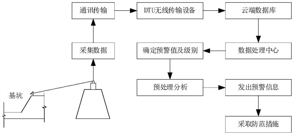
[0045] The data processing center performs filtering, amplitude domain, time domain, frequency domain, and correlation analysis on the data collected after transmission, and can perform preprocessing and analysis based on the previously collected data;
[0046]According to the processed and analyzed data, the corresponding warning response level is determined. The warning response is divided into four levels. Different warning measures are taken according to different warning levels, and real-time warning is performed on relevant key parameters.
[0047] When reaching the third or fourth level of early warning, early warning information is sent through PC terminal, APP terminal, SMS, email, etc., so that preventive measures can be taken in time;
[0048] When the first- and second-level warnings are reached, the warning information will be sent through the PC terminal, APP terminal, SMS, email, etc., and the alarm will be issued through the on-site sound and light alarm device ...
Embodiment 3
[0050] The implementation method is as follows:
[0051] S1: Set up surveying robot and GNSS equipment reference station;
[0052] S2: Build the connection between the survey robot, the GNSS equipment base station and the cloud database connection;
[0053] S3: measure settlement data and upload displacement data;
[0054] S4: Analyze the data level and make early warning of the corresponding level.
[0055] In S1 based on the implementation method:
[0056] Both the surveying robot and the GNSS base station are erected on the top of the slope of the foundation pit and the top of the enclosure structure. The distance between the deformation observation points is less than 20m, and the installation material of the deformation observation points is an L-shaped small prism;
[0057] And the collection frequency is every 30 minutes / time, and the collection frequency is increased in case of emergencies.
[0058] In S2 based on the implementation method:
[0059] The measuremen...
PUM
 Abstract
Description
Claims
Application Information
 - R&D
- Intellectual Property
- Life Sciences
- Materials
- Tech Scout
- Unparalleled Data Quality
- Higher Quality Content
- 60% Fewer Hallucinations
Browse by: Latest US Patents, China's latest patents, Technical Efficacy Thesaurus, Application Domain, Technology Topic, Popular Technical Reports.
© 2025 PatSnap. All rights reserved.Legal|Privacy policy|Modern Slavery Act Transparency Statement|Sitemap|About US| Contact US: help@patsnap.com

