Method for making metropolitan area three-dimensional visible and measurable hypsometric maps

A production method and topographic map technology, applied in the field of map surveying and mapping, can solve the problems that the three-dimensional structure of buildings is not measurable, and it is difficult to express the height of buildings, etc.

Inactive Publication Date: 2005-09-07
西安四维航测遥感中心
View PDF0 Cites 54 Cited by
  • Summary
  • Abstract
  • Description
  • Claims
  • Application Information

AI Technical Summary

Problems solved by technology

With the rapid development of social economy and the rapid expansion of urban construction, the traditional contour line method is difficult to express the height of buildings; in addition, the urban landscape map generated by the center projection method has stereoscopic visual effects, but the three-dimensional stereoscopic effect of buildings is not perfect. Measurable

Method used


Image

  • Method for making metropolitan area three-dimensional visible and measurable hypsometric maps
  • Method for making metropolitan area three-dimensional visible and measurable hypsometric maps
  • Method for making metropolitan area three-dimensional visible and measurable hypsometric maps

Examples


Embodiment Construction

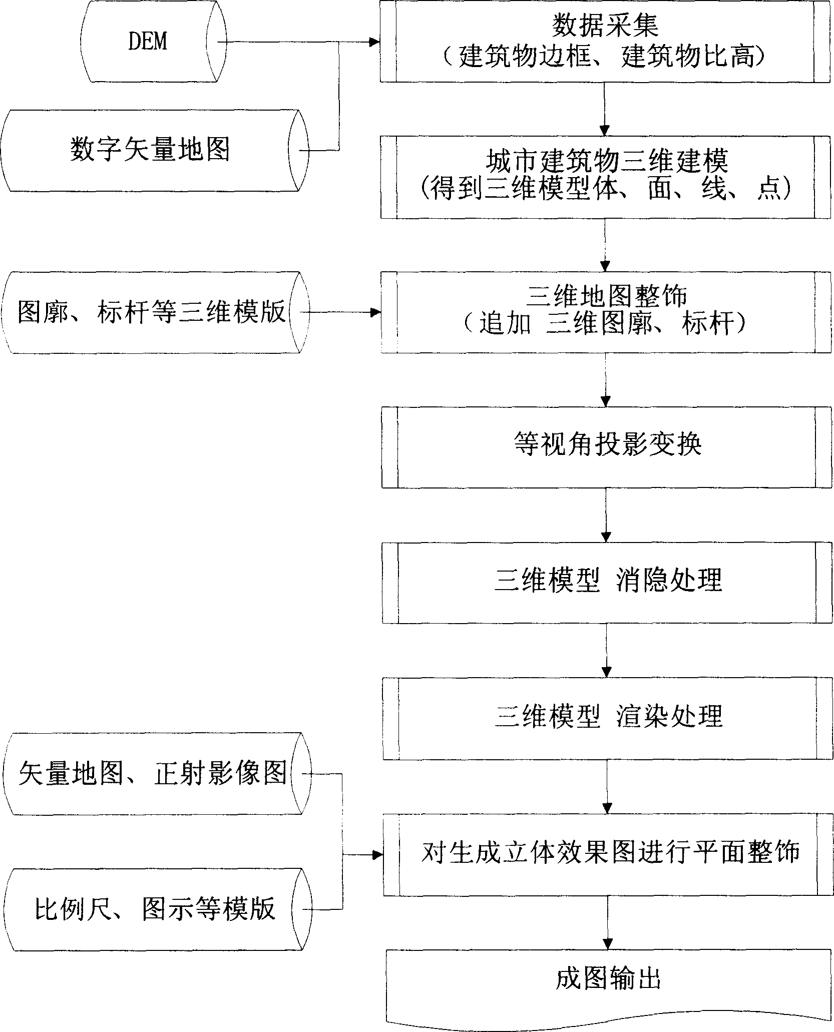
[0018] The present invention is implemented according to the following steps:

[0019] 1. Data collection

[0020] Collect vector digital map data, DEM data and orthophoto map data of an urban area. The distance between DEM data is 10*10 meters, and the ratio height of each building is measured. The measurement accuracy is required to be 0.1 meters. There are three methods of building specific height data collection: 1) On-site mapping and measurement of building specific height; 2) Stereo photogrammetry of building specific height; 3) Laser radar technology directly measures the three-dimensional coordinates of the top of the building . Among them, lidar technology has the highest degree of automation, the best precision, and the highest operating efficiency.

[0021] 2. Building 3D modeling

[0022] The three-dimensional modeling of the building is based on: the projection X, Y of the top of the building on the map plane, the specific height of the building and the digita...


PUM


Abstract

This invention relates to map drawing field and in detail to the maps of each proportions by photo measurement and remote sensing technique and especially to the measurable space map process method of three-dimension. The method comprises the following steps: a, data collecting; b, establishing three-dimensional mode of city architecture; c, decorating the three-dimensional map; d, converting the project with equal visual angle; f, canceling the three-dimensional mode; g, romancing the mode; f, decorating the plane effect of the space graph; I, outputting the generated graph.

Description

Technical field: [0001] The invention relates to the field of map surveying and mapping, in particular surveying and mapping topographic maps of various scales with photogrammetry and remote sensing technology, especially a method for making three-dimensional visible and measurable three-dimensional topographic maps of urban areas. Background technique: [0002] Using photogrammetry and remote sensing technology to survey and map topographic maps of various scales is a traditional technical method with a history of nearly a hundred years. It has been recognized and continued to use the method of contour lines to represent the ups and downs of natural landscapes. With the rapid development of social economy and the rapid expansion of urban construction, the traditional contour line method is difficult to express the height of buildings; in addition, the urban landscape map generated by the center projection method has stereoscopic visual effects, but the three-dimensional ster...

Claims


Application Information

Patent Timeline
Patent Type & Authority Applications(China)
IPC IPC(8): G06T17/05G09B29/00
Inventor 高原常本义陈光裕戴益强李倩张文波高力李劲涛李姜宏王武仕许斌宋宏伟亢三焕
Owner 西安四维航测遥感中心
Why Eureka
Try Eureka