System and method for mapping aircraft position on a non-linear flight procedure chart

a flight procedure and aircraft position technology, applied in the field of mapping systems, can solve the problems of difficult, inaccurate, and difficult to map the position of aircraft on such non-linear charts, and achieve the effects of improving the accuracy of mapping

Active Publication Date: 2019-11-12
GOLDSTEIN HILTON
View PDF24 Cites 2 Cited by
  • Summary
  • Abstract
  • Description
  • Claims
  • Application Information

AI Technical Summary

Benefits of technology

[0009]This summary is provided to introduce a selection of concepts in a simplified form that are further described below in the detailed description. This summary is not intended to identify key features of essential features of the claim...

Problems solved by technology

However, it is common for DPs and STARs to be non-linear or not to scale with respect to real geographic coordinates or distances.
A...

Method used


Image

  • System and method for mapping aircraft position on a non-linear flight procedure chart
  • System and method for mapping aircraft position on a non-linear flight procedure chart
  • System and method for mapping aircraft position on a non-linear flight procedure chart

Examples


Embodiment Construction

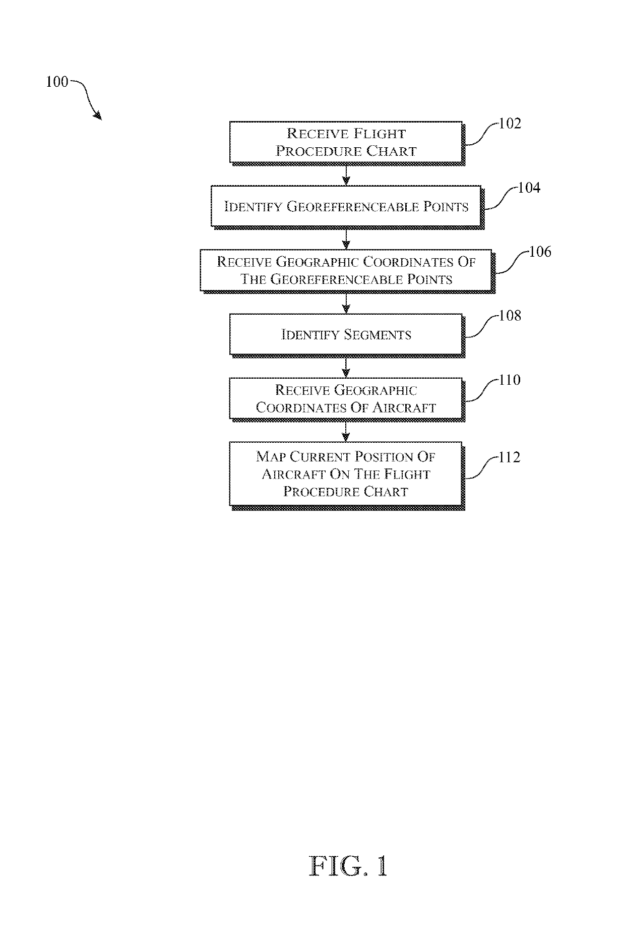
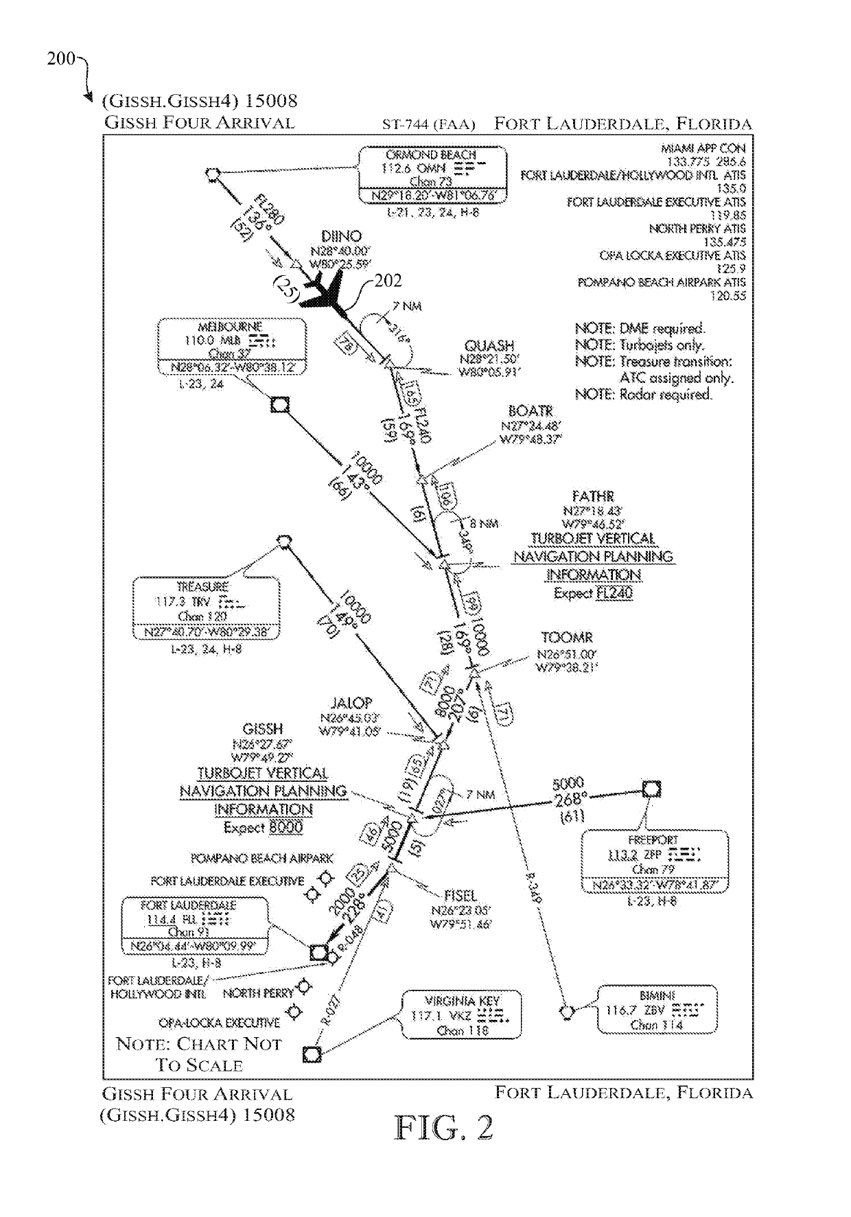
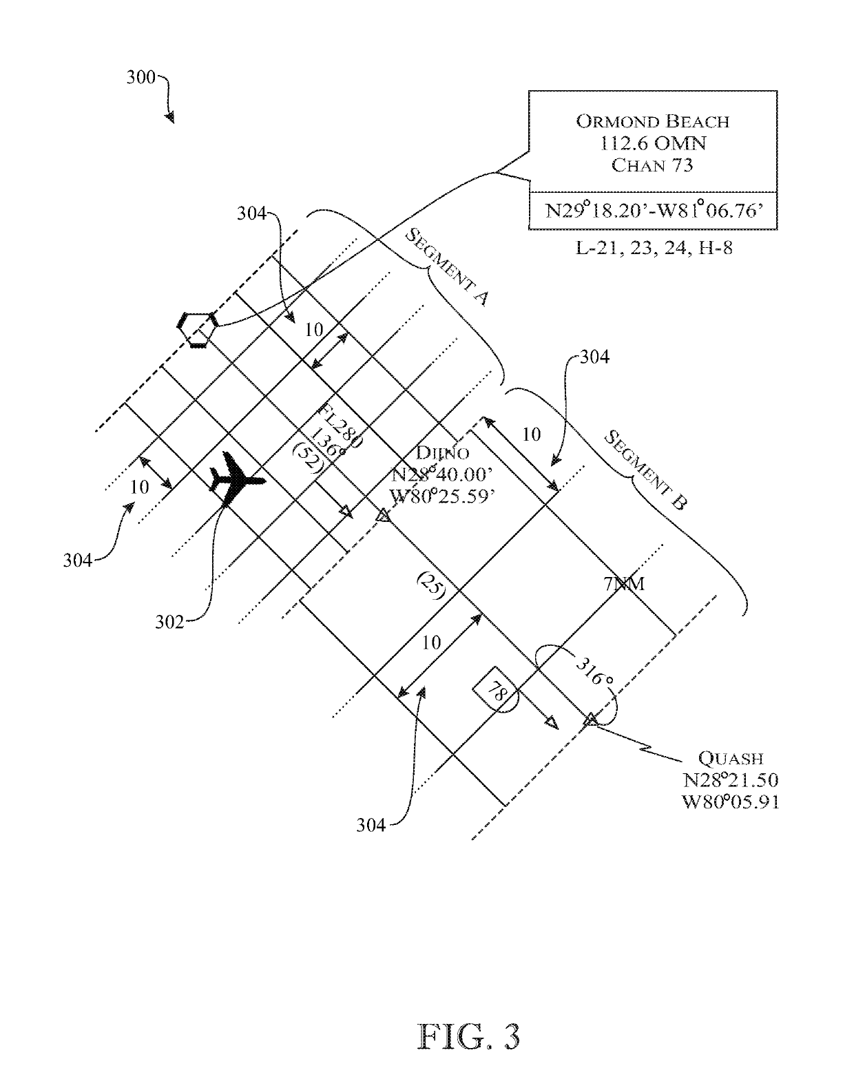
[0031]The following detailed description is merely exemplary in nature and is not intended to limit the described embodiments or the application and uses of the described embodiments. As used herein, the word “exemplary” or “illustrative” means “serving as an example, instance, or illustration.” Any implementation described herein as “exemplary” or “illustrative” is not necessarily to be construed as preferred or advantageous over other implementations. All of the implementations described below are exemplary implementations provided to enable persons skilled in the art to make or use the embodiments of the disclosure and are not intended to limit the scope of the disclosure, which is defined by the claims. For purposes of description herein, the terms “upper”, “lower”, “left”, “rear”, “right”, “front”, “vertical”, “horizontal”, and derivatives thereof shall relate to the invention as oriented in FIG. 2. Furthermore, there is no intention to be bound by any expressed or implied theo...


PUM


Abstract

A system and method for mapping an aircraft position on segments that lie between waypoints on a non-linear map by converting real world geographic coordinates of an aircraft to image X, Y coordinates using an image X, Y length or scale of a respective segment as a basis for the conversion. The aircraft position may be mapped in real time and presented to a user via an aircraft device.

Description

CROSS-REFERENCE TO RELATED APPLICATION[0001]This application claims the benefit of U.S. Provisional Patent Application Ser. No. 62 / 316,577, filed Apr. 1, 2016, which is incorporated herein in its entirety.FIELD OF THE INVENTION[0002]The present invention relates generally to mapping systems, and more particularly to a system and method for mapping an aircraft position on a non-linear flight procedure chart.BACKGROUND OF THE INVENTION[0003]It is common for an aircraft to require navigational assistance, or be required to follow a particular flight plan in accordance with an aviation authority such as the U.S. Federal Aviation Administration (FAA) or air traffic control (ATC) of an airport. For example, in low visibility conditions or at night, a pilot may require guidance to avoid terrain, obstacles, or air traffic and may be required to follow instrument flight rules (IFR). The FAA defines IFR as “Rules and regulations established by the FAA to govern flight under conditions in whic...

Claims


Application Information

Patent Timeline
IPC IPC(8): G01C22/02B64D43/00G01C21/00G01S19/42G01C23/00G08G5/00
CPCB64D43/00G08G5/0047G01C23/00G01C21/005G01S19/42B64D45/04G08G5/0013G08G5/0021G08G5/0052G08G5/0065G08G5/025
Inventor GOLDSTEIN, HILTON
Owner GOLDSTEIN HILTON
Why Eureka
Try Eureka