
Method and apparatus for providing access to maps on a personal digital assistant (PDA)

a personal digital assistant and map technology, applied in the field of electronic maps and geographic information, can solve the problems of cumbersome and impractical carrying a laptop or desktop computer, inability to download maps at the same time, and a large amount of tim

Inactive Publication Date: 2004-08-12
AUTODESK INC
View PDF36 Cites 57 Cited by
  • Summary
  • Abstract
  • Description
  • Claims
  • Application Information

AI Technical Summary

Problems solved by technology

Further, such technicians often need to interact with a map to obtain relevant information.
However, while out in the field, the technicians often do not have a network connection, and carrying a laptop or desktop computer is cumbersome and impractical.
The PDA environment, however, poses several challenges for geographic information systems in terms of memory, storage, processor speeds, wireless transmission rates, and display attributes.
The low bandwidth offered by wireless transmission services, coupled with the slow processors result in unacceptable download times. Also, the technicians in many instances work in trenches or other places where it is not possible to establish a connection to the servers (requiring offline usage).
That is, a portion of a map picture cannot be modified while viewing the map picture.
Because this additional information is in the form of taster data, it is typically time-consuming to download.
Because it is time-consuming to download all of the data, it is inefficient to do so when only a portion of the data is required to satisfy a user's request.
Further, it may not be possible to download all or even a portion of the data onto a PDA.
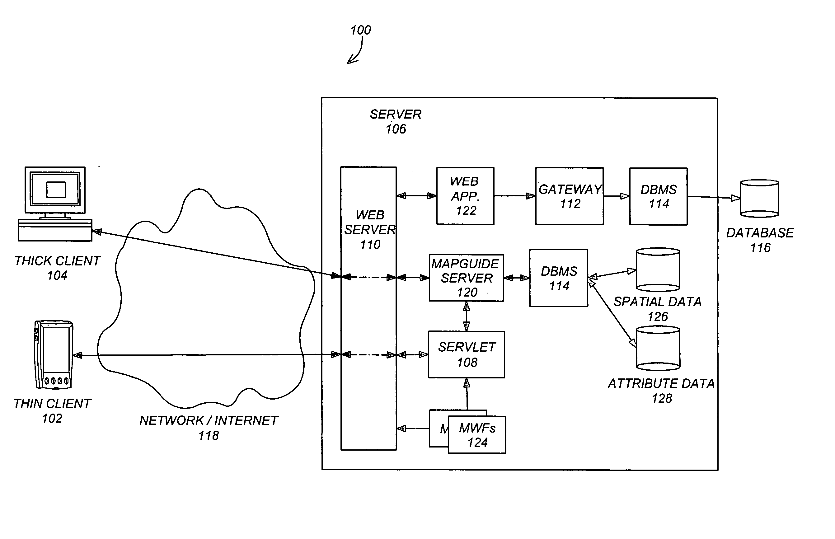
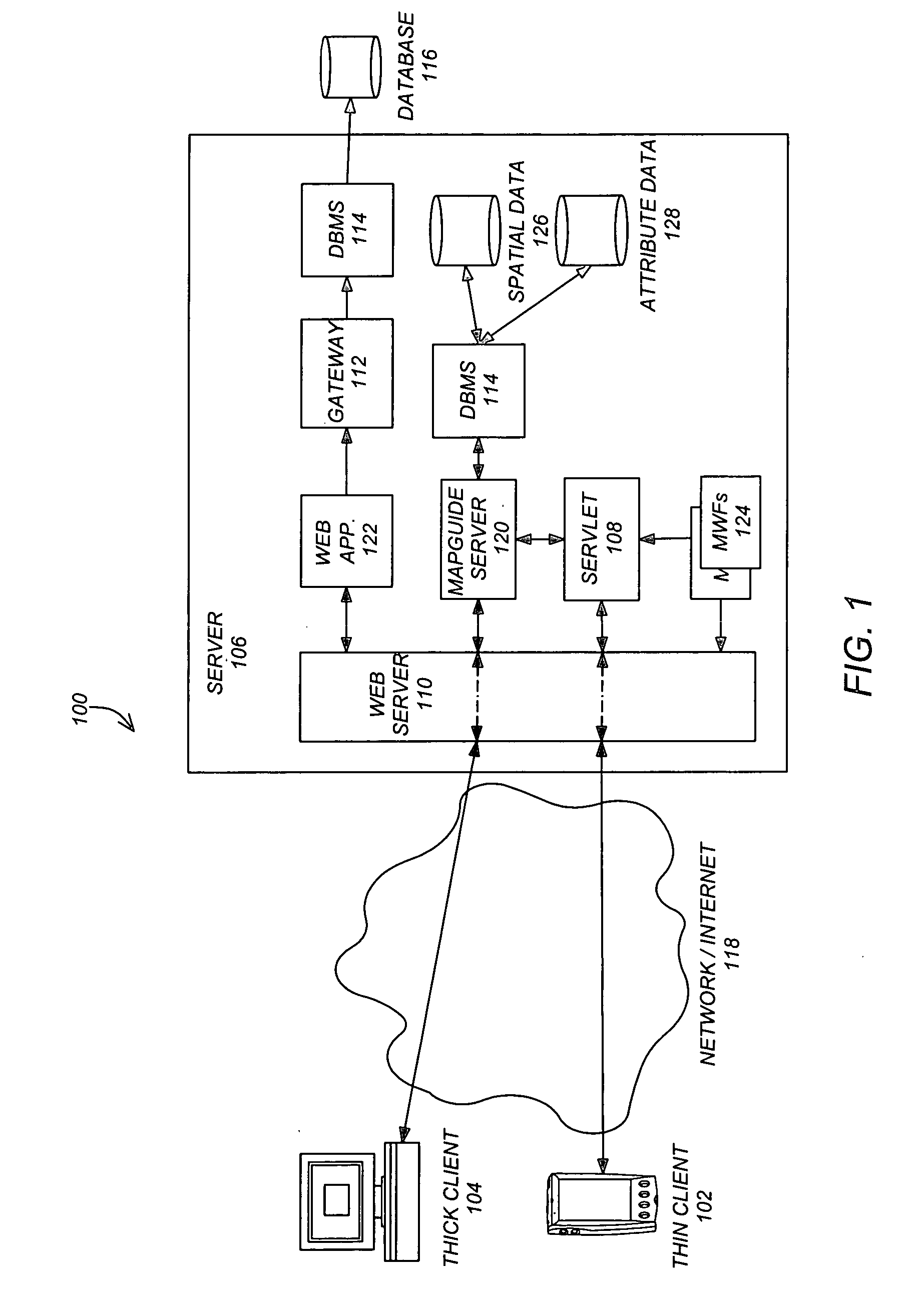
Using these devices, a thin client 102 may not provide the full processing and memory capabilities as a thick client 104.
However, the hardware limitations of a PDA device necessitate software limitations.

Method used


Image

  • Method and apparatus for providing access to maps on a personal digital assistant (PDA)
  • Method and apparatus for providing access to maps on a personal digital assistant (PDA)
  • Method and apparatus for providing access to maps on a personal digital assistant (PDA)

Examples


Embodiment Construction

[0078] FIGS. 6-8 illustrate various implementations / situations in accordance with one or more embodiments of the invention. In the implementations of FIGS. 6-8 incidents in the field (e.g., failure incidents) occur wherein a field technician 602 retrieves assignments to repair / work at the failure incident location. Technician 602 retrieves map and geographic data for the failure location on a personal digital assistant and interacts with and updates the map and geographic data.

[0079] Field Technician Working Offline

[0080] With respect to FIG. 6, a failure notification 606 creates a failure notification event for the back office system 604. Thus, upon a location in the field failing (e.g., a broken water main or street light), a notifier 600 notifies the back office system 604 where the failure incident is recorded for processing. The failure notification system 606 operates asynchronously from technician 602 activities.

[0081] FIG. 6 illustrates the implementation wherein a field tec...


PUM


Abstract

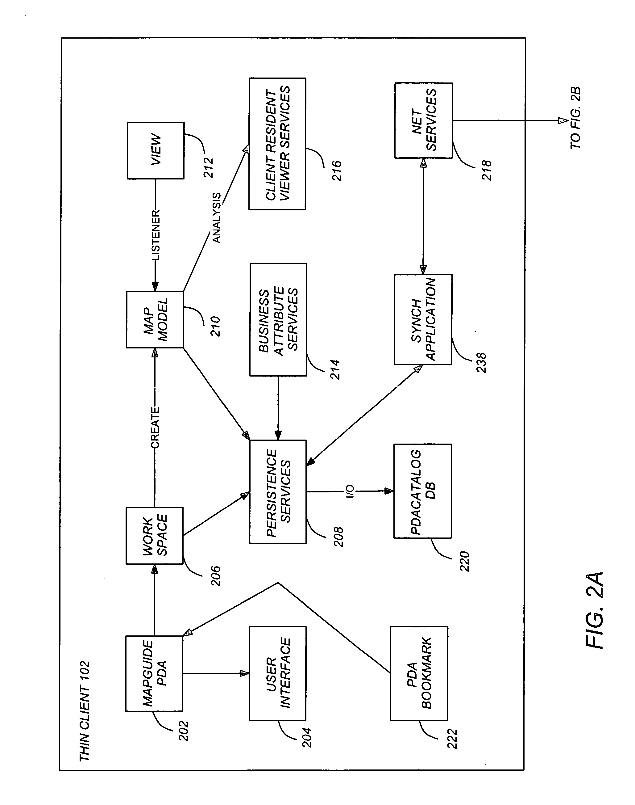
One or more embodiments of the invention provide for an interactive geographic information system on a personal digital assistant (PDA). The system enables the viewing and interaction with geographic information on a PDA. Such information is available while the PDA is connected to a network (i.e., online) and while disconnected (i.e., offline). Embodiments provide the PDA with the functionality commonly available in a standard client comprised of a complete computer system. For example, embodiments provide raster maps for multiple zoom levels, with each zoom level comprising multiple tiles allowing for "virtual roaming" across a map. One or more embodiments also provide raster zooms (by scaling existing raster tiles), selectable vector geometry (for interacting and highlighting with user objects), geo-referencing information for map navigation, meta-data in the form of layer definitions (visibility, display attributes, etc.), links to object attributes in databases, links to object reports generated by corporate web servers, uploadable, sharable redlining data (created from scribbles on the field), offline access on a PDA, and a compact PDA database. Thus, one or more embodiments of the invention provide interactive maps and business objects that can be viewed and queried on a PDA, both in an online and offline mode.

Description

[0001] This application claims the benefit under 35 U.S.C. Section 120 of the following co-pending and commonly-assigned U.S. utility patent application(s), which is / are incorporated by reference herein:[0002] U.S. patent application Ser. No. 10 / 642,857, filed Aug. 18, 2003, by Gregory Andrews Roy, Osman Hamid Bux, Kevin Glen Robinson, and Roderick Gaetan Munro, entitled "VECTOR BASED GEOGRAPHIC DATA", attorney's docket number 30566.17-US-C3, which application is a continuation of commonly-assigned patent application Ser. No. 10 / 008,625, filed Dec. 6, 2001, by Gregory Andrew Roy, Osman Hamid Bux, Kevin Glen Robinson, and Roderick Gaetan Munro, entitled "VECTOR BASED GEOGRAPHIC DATA", attorneys' docket number 30566.17-US-C2, now U.S. Pat. No. 6,642,925, issued on Nov. 4, 2003; which application is a continuation of commonly-assigned patent application Ser. No. 09 / 411,506, filed Oct. 4, 1999, by Gregory Andrew Roy, Osman Hamid Bux, Kevin Glen Robinson, and Roderick Gaetan Munro, entit...

Claims


Application Information

Patent Timeline
Patent Type & Authority Applications(United States)
IPC IPC(8): H04Q7/20
CPCG06Q10/087G06Q10/025
Inventor CHITHAMBARAM, NEMMARAMARANTZ, HOWARDDEAGUIAR, JOHN R.ROY, GREGORY ANDREWROBINSON, KEVIN GLENMUNRO, RODERICK GAETAN
Owner AUTODESK INC
Learn More