Geographic information system

a geoinformation system and information system technology, applied in the field of geoinformation systems, can solve the problems of inflexibility to handle the transmission of large volume and variable image sizes in a webgis environment, and the challenge of voluminous and heterogeneous data dissemination

Inactive Publication Date: 2005-07-28
GEORGE MASON INTPROP INC
View PDF6 Cites 67 Cited by
  • Summary
  • Abstract
  • Description
  • Claims
  • Application Information

AI Technical Summary

Problems solved by technology

While WebGIS is gaining in popularity, dissemination of voluminous and heterogeneous data becomes a challenge, as the Internet bandwidth is not limitless.
Although the second issue has been addressed by various proposed suggestions, the research on performance of WebGIS has limitations on two issues: (1) most methods focus on only one aspect of the performance problem; and (2) most methods do not consider how the hierarchical structure of map, layer, object and attribute may affect performance.
But, they do not have the flexibility to handle efficiently the transmission of large volume and variable image sizes in a WebGIS environment.
TerraServer (available from the United States Geological Survey of Reston, Va.) uses this technique to assist SQL Server to manage images, but this approach is not applicable for managing pyramid in WebGIS, as most WebGIS cannot come with SQL Server.
This temporary approach is not suitable for managing images in WebGIS because the response time will be too long if the pyramid is built for every access.
Unfortunately, this combined technique is effective for raster data only, and the complex nature of WebGIS involves the handling of both raster data and vector data, as well as the support of spatial analysis.
Moreover, users may request raster images in a relatively random manner and therefore, the pre-fetching technique may not be efficient and effective in handling random requests.
However, these processes do not take into account the de facto hierarchical geographic data organization of maps, layers, objects, and attributes.
Therefore, these processes cannot be used generically to handle heterogeneous datasets in a WebGIS environment.

Method used


Image

  • Geographic information system
  • Geographic information system
  • Geographic information system

Examples


Embodiment Construction

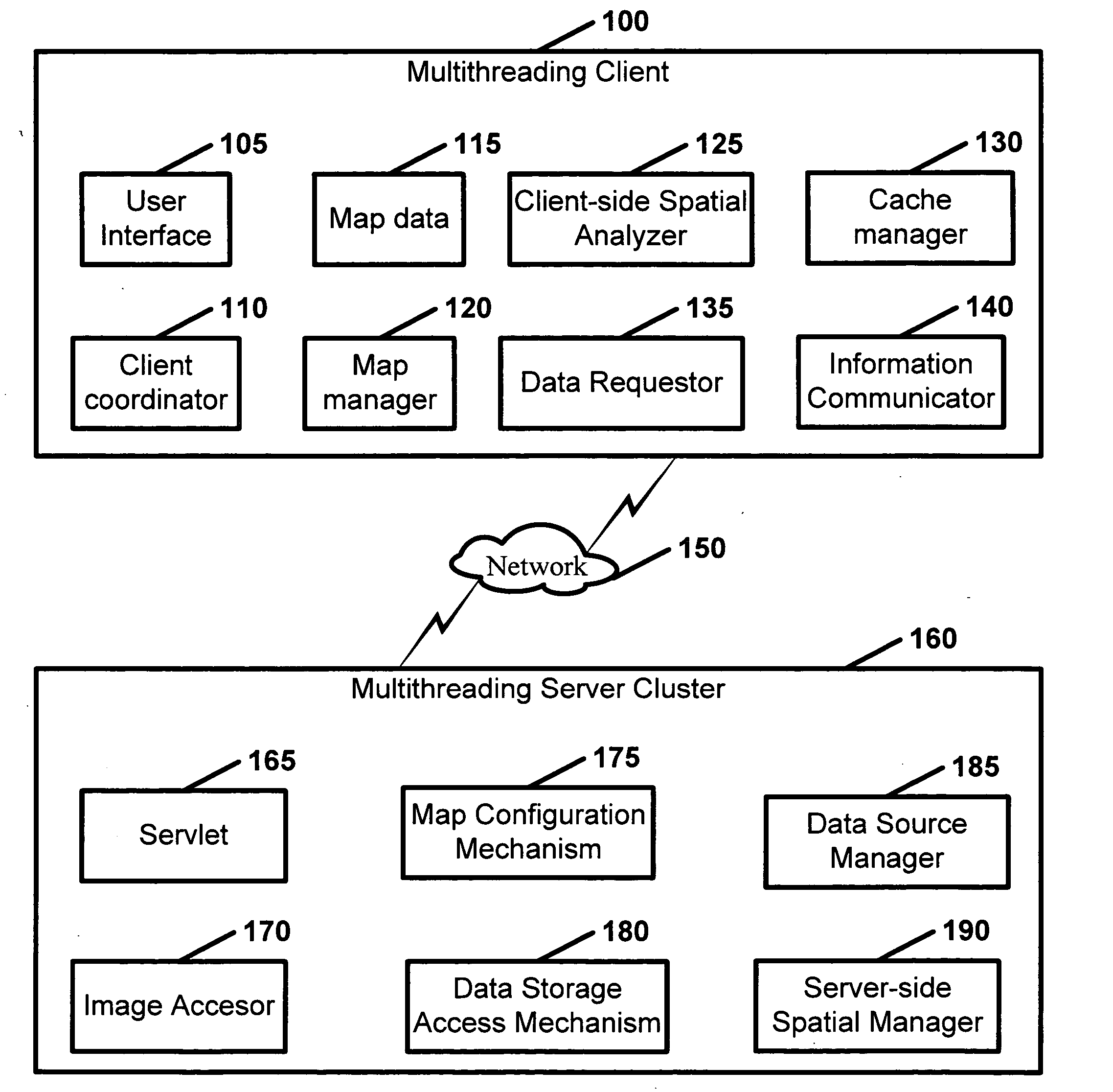
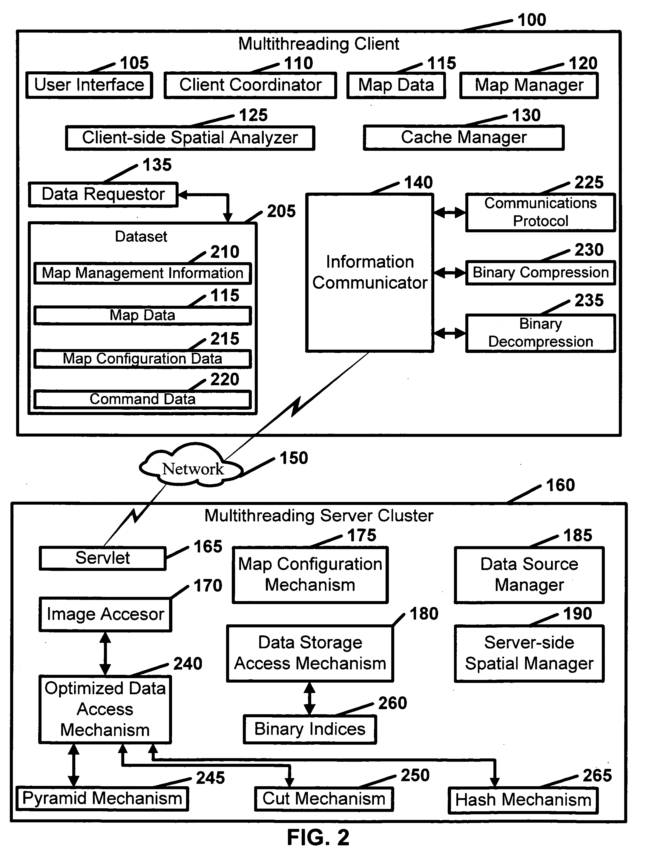
[0040] The present invention relates to a geographic information system. Specifically, the present invention is a set of techniques, which may be used together to improve system-wide performance of a geographic information system, such as a web-based GIS. Techniques include, for example, pyramid, cut and hash indexing; multithread and dynamic request, caching and binary compression. Pyramid, cut and hash indexing techniques can be used for managing large image datasets on the server side, while well-developed R-tree indexing techniques can be used for indexing vector data. Multithread and dynamic request techniques can be used for handling users' concurrent access, as well as client-side concurrent data requests. Caching techniques can be used for keeping some information on the client side based on the submitted dynamic requests. Binary compression techniques can be used to reduce the transmission volume of data.

[0041] Referring to FIGS. 1 and 2, a logical expression of the presen...


PUM


Abstract

Disclosed is a geographic information system which comprises a multithreading client and a multithreading server cluster. The multithreading client includes at least one user interface, at least one client coordinator, map data, at least one map manager, at least one client-side spatial analyzer, at least one cache manager, at least one data requester, and at least one information communicator. The multithreading server cluster includes: at least one servlet, at least one image accessor, at least one map configuration mechanism; at least one data storage access mechanism, at least one data source manager, and at least one server-side spatial manager.

Description

CROSS REFERENCE TO RELATED APPLICATIONS [0001] The present application claims benefit of provisional patent application Ser. No. 60 / 523,105 to Yang et al., filed on Nov. 19, 2003, entitled “Geographic Information System,” which is hereby incorporated by reference.BACKGROUND OF THE INVENTION [0002] The fast-paced development of a geographic information system (“GIS”) has triggered some researchers to reconsider the fundamental essence of GIS and its social implications. GIS (sometimes described by the term “media”) has been widely used in various types of business, government and university projects. For instance, in North America alone, the value of the GIS market, even in a slow economy, can increase from $1.4 billion in 2001 to $2.0 billion in 2004. This market value will continue to expand because GIS is finding new markets on the Internet. Today, GIS serves as a means of communication by conveying information and knowledge to the public. This booming trend of GIS is potentially ...

Claims


Application Information

Patent Timeline
Patent Type & Authority Applications(United States)
IPC IPC(8): G06F17/30
CPCG06F17/30241G06F16/29
Inventor YANG, CHAOWEIKAFATOS, MENASWONG, DAVID W.WOLF, HENRY D.YANG, RUIXIN
Owner GEORGE MASON INTPROP INC
Why Eureka
Try Eureka