Method, system and program for managing geographic data stored in a database

a database and geographic data technology, applied in the field of information retrieval systems, can solve the problem of wasting time on these kinds of queries

Inactive Publication Date: 2005-10-06
IBM CORP
View PDF12 Cites 54 Cited by
  • Summary
  • Abstract
  • Description
  • Claims
  • Application Information

AI Technical Summary

Problems solved by technology

Therefore time would be wasted on these sorts of queries that attempt to search across peripheral borders.

Method used


Image

  • Method, system and program for managing geographic data stored in a database
  • Method, system and program for managing geographic data stored in a database
  • Method, system and program for managing geographic data stored in a database

Examples


Embodiment Construction

[0021] The following detailed description of the embodiments of the present invention does not limit the implementation of the embodiments to any particular computer programming language. The computer program product may be implemented in any computer programming language provided that the OS (Operating System) provides the facilities that may support the requirements of the computer program product. A preferred embodiment is implemented in the C or C++ computer programming language (or may be implemented in other computer programming languages in conjunction with C / C++). Any limitations presented would be a result of a particular type of operating system, computer programming language, or data processing system and would not be a limitation of the embodiments described herein.

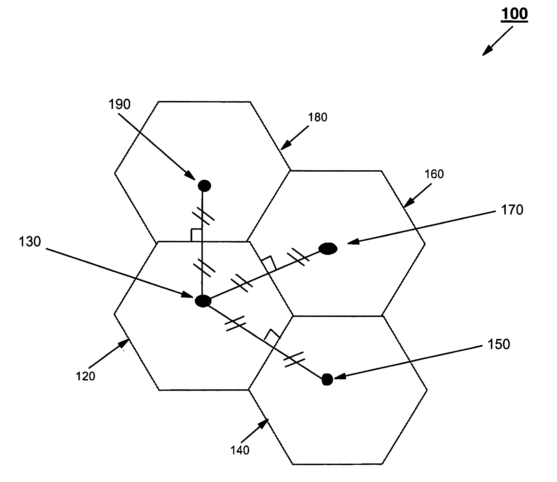
[0022]FIG. 1 shows a mosaic 100 of non-rectilinear shaped cells 120, 140, 160 and 180 (hereinafter ‘cells’). The mosaic 100, in this example, is formed into a mosaic of Voronoi cells. A Voronoi tessellation i...


PUM


Abstract

A method, a data processing system and an article of manufacture for managing geographic identifiers stored in a database is described herein. The geographic identifiers each identify a respective geographic feature displayed on a surface map space partitioned by a mosaic of non-rectilinear shaped cells. The data processing system includes an accessing module for accessing a geographic look-up table and an index for the geographic look-up table, the geographic look-up table and the index being stored in the database, an identification module for identifying, from the index, stored row identifiers associated with a subset of the mosaic of non-rectilinear shaped cells, and a retrieving module for retrieving, from the geographic look-up table, stored geographic identifiers associated with the identified stored row identifiers.

Description

FIELD OF THE INVENTION [0001] The present invention relates to information retrieval systems, and more particularly the present invention relates to a method, system and computer program product for managing geographic data stored in a database. Background [0002] Geographic data relates to data concerning the topography of a specific geographic region, and this data may include geodetic data and non-geodetic data. Geodetic data refers to geographic data that is stored in an angular coordinate system (such as, for example, latitude and longitude information) that is geo-referenced to the earth's surface. Non-geodetic data includes geographic data that has been projected to a “flat” map. [0003] It is generally known to overlay rectilinear shaped cells, typically in the form of a straight-lined grid pattern, overtop of a surface map displaying geographic features, and then to store geographic data related to the geographic features along with associated cell IDs in a database. The each...

Claims


Application Information

Patent Timeline
Patent Type & Authority Applications(United States)
IPC IPC(8): G06F7/00G06F17/30
CPCY10S707/99932G06F16/29Y10S707/99933
Inventor ASHWORTH, MARK A.MARICONDA, JOE
Owner IBM CORP
Why Eureka
Try Eureka