Method and system for generating and presenting off-road travel routes

a technology of off-road travel and route generation, applied in the field of navigation, can solve the problems of existing systems failing, soldiers are susceptible to surprise attacks by enemy units, existing systems that do not consider the position and attack range of enemy units, etc., and achieve the effect of wasting energy and reducing energy expenditure across the terrain

Active Publication Date: 2006-06-01
PRIMORDIAL
View PDF18 Cites 36 Cited by
  • Summary
  • Abstract
  • Description
  • Claims
  • Application Information

AI Technical Summary

Problems solved by technology

Specifically, existing systems fail to:
Existing systems do not consider the position and attack range of enemy units.
As a result, soldiers are susceptible to surprise attacks by enemy units.
As a result, soldiers endure unnecessary risk and delays as they discover obstructions during combat.
As a result, soldiers face unnecessary enemy attacks en route.
Existing systems do not take into account obstacles erected by the enemy when generating a route.
As a result, soldiers encounter impassable terrain en route.
As a result, soldiers miss shortcuts and waste energy passing through difficult terrain.
As a result, reviewing the route distracts soldiers from the battlefield and exposes them to possible enemy attack.

Method used


Image

  • Method and system for generating and presenting off-road travel routes
  • Method and system for generating and presenting off-road travel routes
  • Method and system for generating and presenting off-road travel routes

Examples


Embodiment Construction

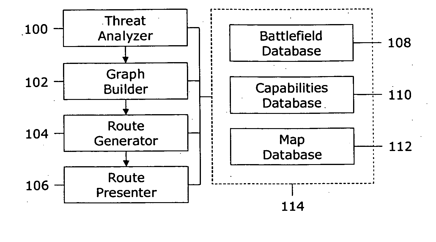
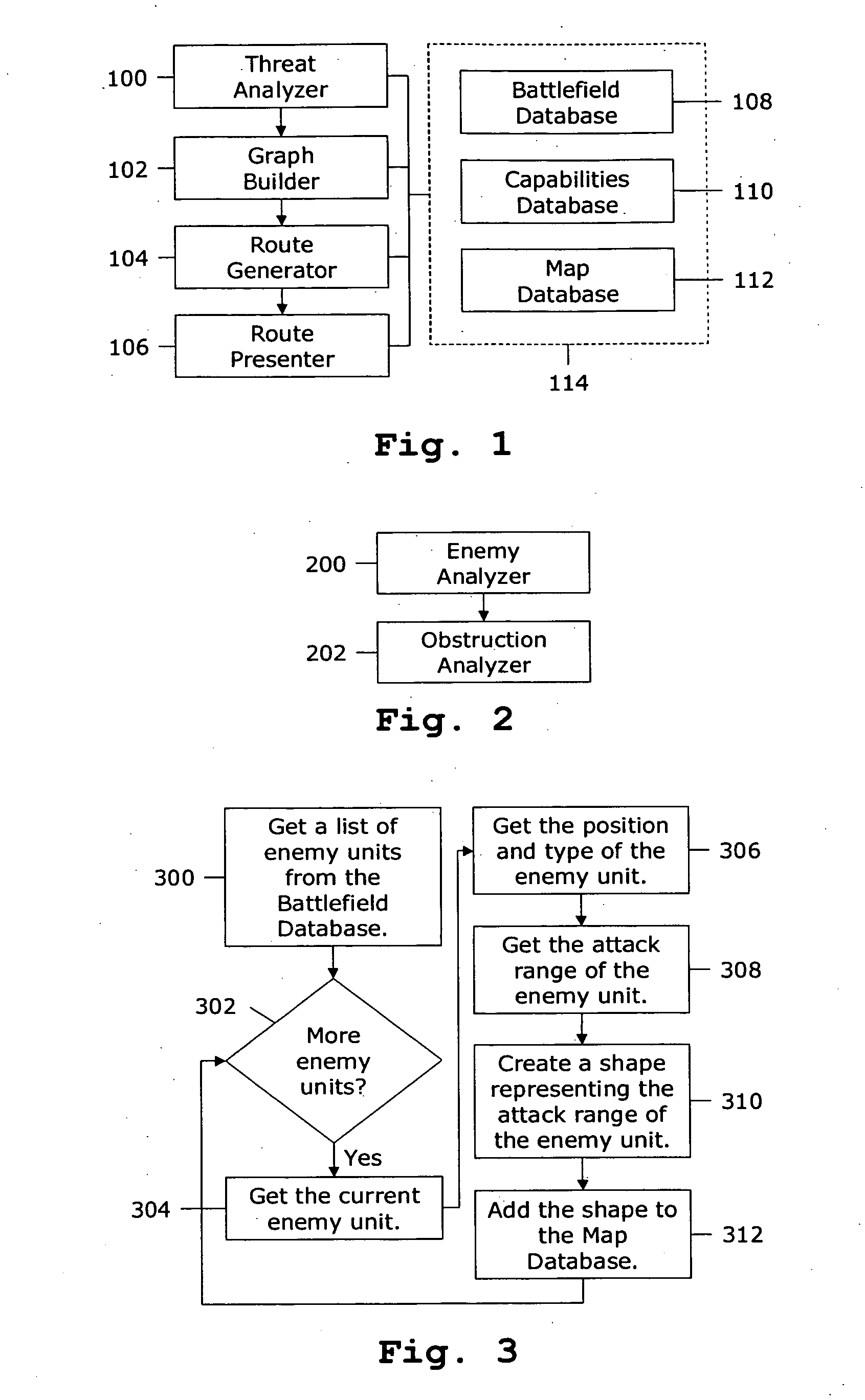
[0059]FIG. 1 shows a preferred embodiment of the present invention. The processing is performed by four components. The Threat Analyzer 100 analyzes threats posed by enemy units and battlefield obstructions. The Graph Builder 102 constructs a graph representing the battlefield. The graph consists of nodes and edges. Edge costs reflect the danger and difficulty of traversing the associated path. The Route Generator 104 generates an optimal route through the battlefield from a source node to a destination node. The Route Presenter 106 presents the route to a soldier as he or she traverses the battlefield.

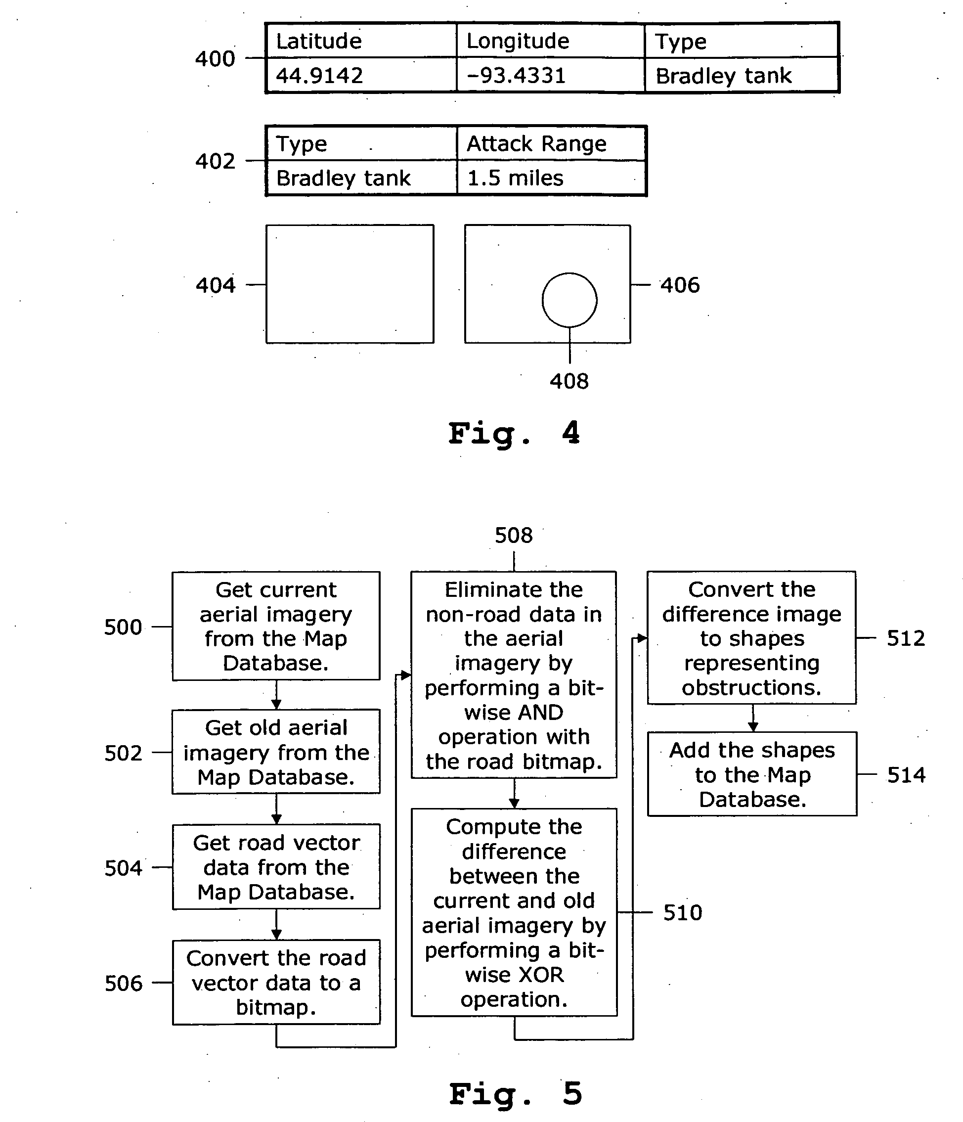
[0060] Each of the components has access to a collection of databases 114. The Battlefield Database 108 contains the positions and descriptions of enemy units. The Capabilities Database 110 contains types of friendly and enemy units and their capabilities. The Map Database 112 contains geographic information including black and white aerial imagery and road vector data. The Map Datab...


PUM


Abstract

A computer-implemented method for generating and presenting off-road travel routes based on terrain and obstruction analysis. The method includes a Threat Analyzer (100) for assessing threats that may impede progress, a Graph Builder (102) for constructing a graph representing an individual's environment, a Route Generator (104) for generating a route that avoids the threats, and a Route Presenter (106) for guiding the individual along the route. The Threat Analyzer (100) includes an Obstruction Analyzer (202) for detecting obstructions in aerial imagery. The Graph Builder (102) includes a Cost Evaluator (712) that takes into account traversal speeds for individuals across various types of terrain. The Route Presenter (106) overlays the route on aerial imagery and provides real-time guidance as the individual traverses the route.

Description

CROSS-REFERENCE TO RELATED APPLICATIONS [0001] This application is a continuation of U.S. patent application Ser. No. 10 / 409,832, filed Apr. 9, 2003, now allowed, incorporated by reference herein.BACKGROUND OF INVENTION [0002] 1. Field of the Invention [0003] This invention relates to navigation, specifically to generating and presenting off-road travel routes based on terrain and obstruction analysis. [0004] 2. Discussion of the Background [0005] On 1993 Oct. 03, U.S. Army Rangers raided a compound in Mogadishu, Somalia. The U.S. was responding to seizures of humanitarian supplies by the warlord, General Mohamed Aideed. During the raid, General Aideed's forces fired a surface-to-air missile, downing a U.S. Blackhawk helicopter. As a result, U.S. Army commanders redirected foot soldiers and Humvee convoys to aid the injured pilots. [0006] With bullets whizzing and enemy forces closing in on the helicopter's debris, commanders relied on paper maps and surveillance video to generate r...

Claims


Application Information

Patent Timeline
Patent Type & Authority Applications(United States)
IPC IPC(8): G01C21/32
CPCG01C21/20G06Q10/047
Inventor MILBERT, RANDY L.
Owner PRIMORDIAL
Why Eureka
Try Eureka