Method to share and exchange geographic based information

a geographic information and information technology, applied in the field of geographic information sharing and exchange, can solve the problems of not facilitating the organization and interrelation of various geographic information sources and geographic data structures, corresponding increase in difficulty and complexity of referencing, organizing and managing geographic resources, and no existing system enables users to store multiple views of the same data, etc., to achieve the effect of maintaining exactness and reproducibility, and easy sharing with others

Inactive Publication Date: 2006-10-12
MUD SPRINGS GEOGRAPHERS
View PDF6 Cites 20 Cited by
  • Summary
  • Abstract
  • Description
  • Claims
  • Application Information

AI Technical Summary

Benefits of technology

[0006] The present invention is directed at simplifying and making GIS information easy to share with others, with the objects maintaining the exactness and reproducibility of the information from one GIS to the other, without any further processing. The exchange technology according to this invention enables GIS information fully populated by data and metadata to be exchanged as a single exchange file. Processing and further analysis are not limited once the exchange file is imported into a new or existing GIS database.

Problems solved by technology

Along with the increasing availability of location based information, there has been a corresponding increase in the difficulty and complexity of referencing, organizing, and managing geographic resources.
While such open standards increase the amount of geographic information that is accessible to a user using a single application, they do nothing to facilitate the organization and interrelation of various geographic information sources and geographic data structures.
None of the existing systems do enable the user to store multiple views of same data (zoom and color rendering), to freely exchange and amend existing data and to display the data with the same exactness as in the original database.
Many of the problems that are impeding the full potential and applicability of geographic information systems have not been adequately addressed by conventional approaches.
There still exists the difficulty of exchanging freely available geographic information to all interested users within an organization.
Moreover, there is no geographic information system that can adequately coordinate the use and execution of multiple applications that may be needed to display geographic information originating from different data sources.

Method used


Image

  • Method to share and exchange geographic based information
  • Method to share and exchange geographic based information
  • Method to share and exchange geographic based information

Examples


Embodiment Construction

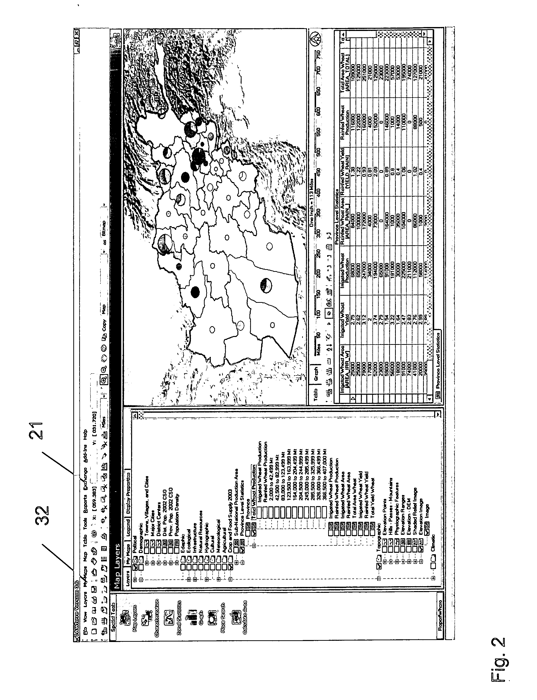
[0018] A simplified approach to sharing and exchanging geographic-based information containing the maps and corresponding data and metadata was developed to enable easy sharing of information for decision support tools. Current Geographical Information Systems (GIS) technologies are limited in their ability to share maps and data in the exact format that the user created the information. This technology shares the corresponding data with the map information (not just a ‘picture’ of the data—e.g., a static map) in the exact form that the user wants to provide to other users of the software application. The technology described in this disclosure provides the unique ability for users to share the information directly with other users of the technology, eliminating process and setup of importing new information into the decision-support software. Users can then utilize the information to explore the map and database information, to add their own data, and to make further decisions, ena...


PUM


Abstract

A simplified approach to sharing and exchanging geographic-based information containing the maps and corresponding data and metadata was developed to enable easy sharing of information for decision support tools. Current Geographical Information Systems (GIS) technologies are limited in their ability to share maps and data in the exact format that the user created the information. This technology shares the corresponding data with the map information (not just a ‘picture’ of the data—e.g., a static map) in the exact form that the user wants to provide to other users of the software application. The technology and use of this software application provides the unique ability for users to share the information directly with other users of the software, eliminating process and setup of importing new information into the spatial decision-support software. Users can then utilize the information to explore the map and database information, to add their own data, and to make further decisions, enabling them to modify and change the information and exchange the information with others in the same manner.

Description

BACKGROUND OF THE INVENTION [0001] Managing, organizing and displaying geographic information using computers has become increasingly common. Such use of geographic information has proved to be valuable in many industries and organizations, such as governmental agencies, public utilities, and agribusiness. Computer display of geographic information allows vast amounts of information to be efficiently communicated to users and allows the geographic information to be easily edited. [0002] With the recent explosive growth of the Internet, numerous geographic information resources at remote sites around the world have become instantly available to users, regardless of their location. Along with the increasing availability of location based information, there has been a corresponding increase in the difficulty and complexity of referencing, organizing, and managing geographic resources. In order to retrieve geographic information, the user or the retrieving computer must acquire the info...

Claims


Application Information

Patent Timeline
Patent Type & Authority Applications(United States)
IPC IPC(8): G06F7/00
CPCG06F17/30241G06F16/29
Inventor CORBETT, JOHN
Owner MUD SPRINGS GEOGRAPHERS
Why Eureka
Try Eureka