Driving route planning system and method

a technology of driving route and planning system, applied in the field of navigation techniques, can solve the problems of affecting the speed of traffic, user still has to spend a lot of time to reach the destination, etc., and achieve the effect of avoiding congestion and saving driving tim

Inactive Publication Date: 2006-11-02
MITAC INT CORP
View PDF23 Cites 34 Cited by
  • Summary
  • Abstract
  • Description
  • Claims
  • Application Information

AI Technical Summary

Benefits of technology

[0013] In views of the above-mentioned problems of the prior art, it is a primary objective of the present invention to provide a driving route planning system and method for adjusting a driving route at any time when receiving real-time traffic information, to reduce time to driving a car. It is another objective of the present invention to provide a driving route planning system and method for a user to avoid congested roads and improve a traffic congested situation by adjusting a driving route.
[0018] The present invention makes the use of a data processing center to collect real-time traffic information. Therefore, an electronic navigation device can acquire corresponding traffic information happening at any time, and adjust a driving route accordingly, and a user can avoid congested route and saves driving time.

Problems solved by technology

For example, the expected part means that a road congestion happens in a certain area such as a highway during a certain period such as a long weekend, and the unexpected part means another road congestion resulted from a car accident.
The road interruption factor means that a road is interrupted due to an act of Providence such as an earthquake, which may interrupt a road completely.
However, the above-mentioned car navigation equipment, when determining the “recommended driving route”, takes only a shortest route between the position of departure and the destination into consideration, without further considering whether any road in the “recommended driving route” is blocked or not.
In result, the user still has to spend much time to arrive the destination, even though the car navigation equipment has determined a “shortest”“recommended driving route”, which includes the blocked road.

Method used


Image

  • Driving route planning system and method
  • Driving route planning system and method
  • Driving route planning system and method

Examples


Embodiment Construction

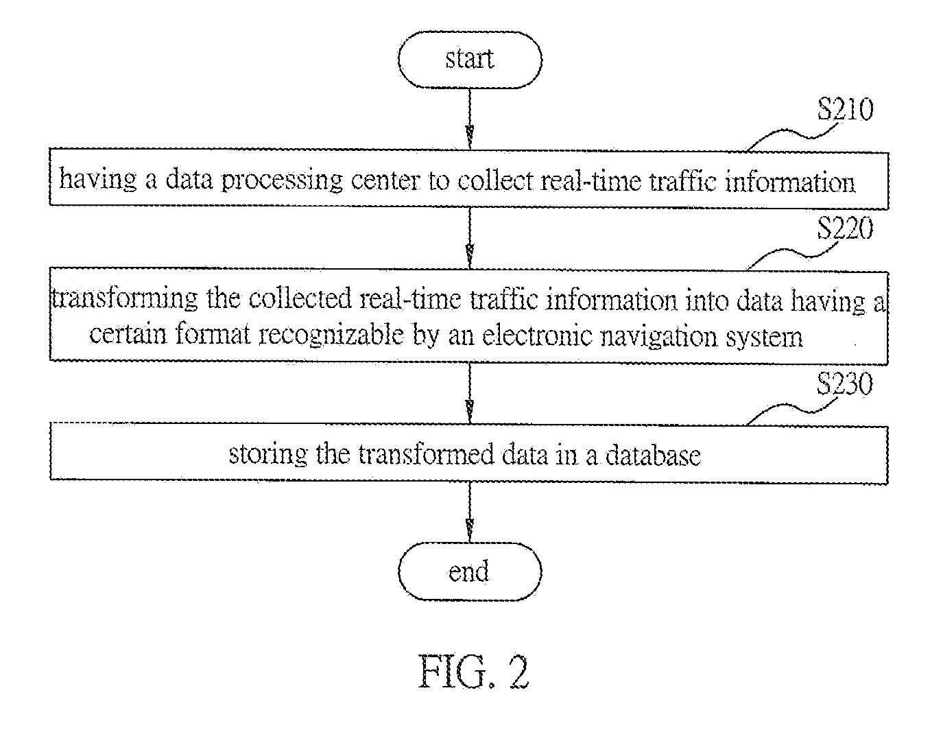
[0023] The following illustrative embodiments are provided to illustrate the disclosure of the present invention, these and other advantages and effects can be apparently understood by those in the art after reading the disclosure of this specification. The present invention can also be performed or applied by other different embodiments. The details of the specification may be on the basis of different points and applications, and numerous modifications and variations can be devised without departing from the spirit of the present invention.

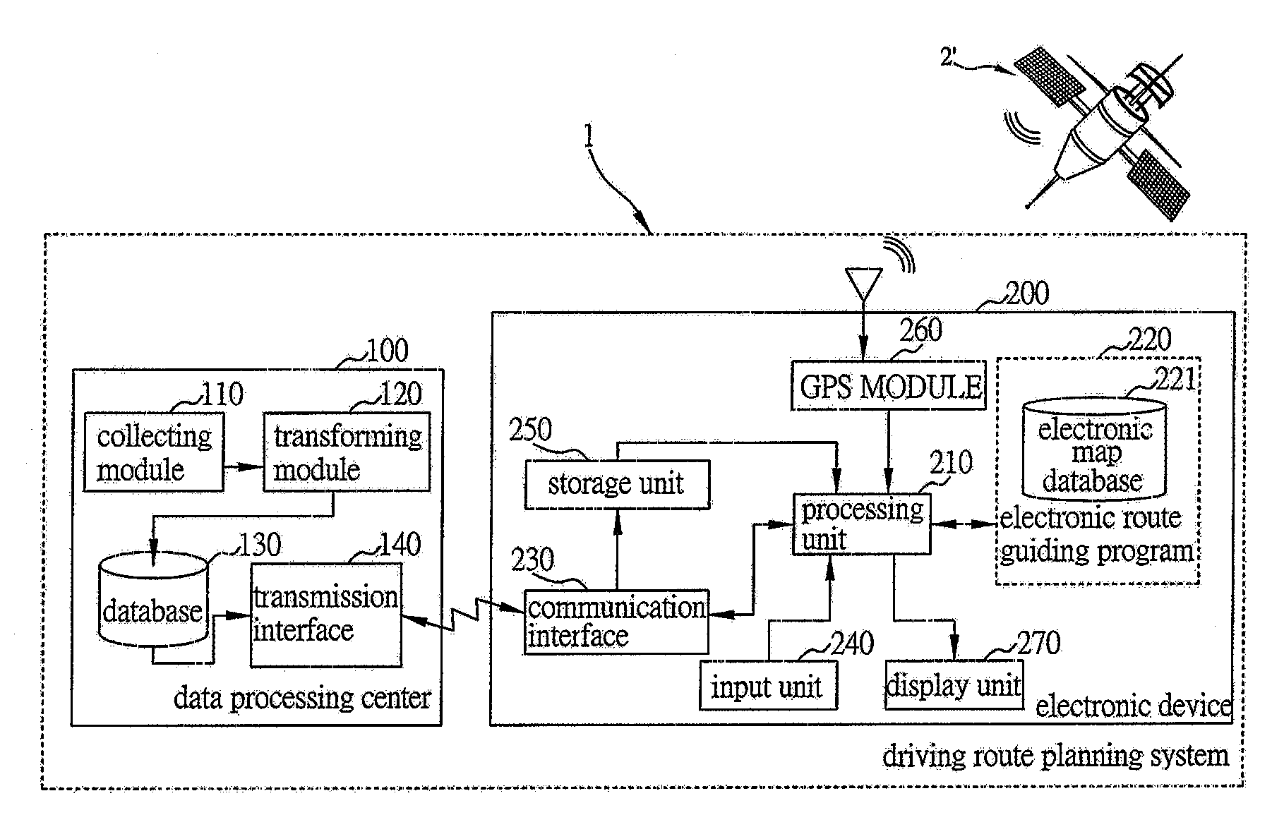
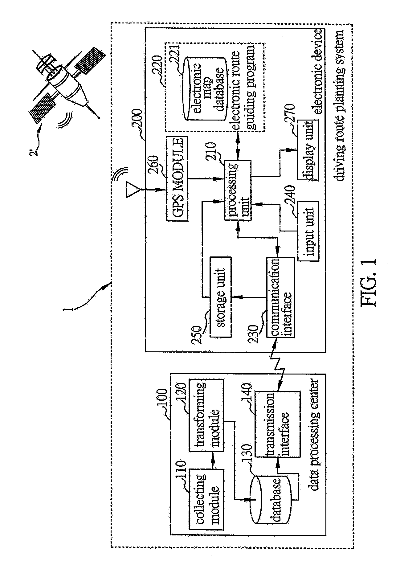
[0024]FIG. 1 is a functional block diagram of a driving route planning system 1 of the preferred embodiment according to the present invention. The driving route planning system 1 comprises a data processing center 100 and at least an electronic device 200. Only one electronic device 200 is introduced herewith as an example to demonstrate the driving route planning system 1. Another driving route planning system of the present invention can com...


PUM


Abstract

A driving route planning system includes a data processing center for collecting real-time traffic information and storing the collected real-time traffic information in a database. The data processing center includes a transmission interface for emitting the stored real-time traffic information receiving requests. The system further includes an electronic device including an electronic route guiding program for planning driving routes, a communication interface for connecting to the data processing center to receive the traffic information transmitted from the data processing center and emit real-time traffic information updating request to the data processing center, and a storage unit for receiving the real-time traffic information received by the communication interface. The electronic route guiding program, when planning a driving route, compares an overlap situation between the real-time traffic information stored in the storage unit and the planned driving route, and takes the overlap situation as a basis to re-plan the driving route.

Description

BACKGROUND OF THE INVENTION [0001] 1. Field of the Invention [0002] This invention relates to navigation techniques, and more particularly, to a driving route planning system and method applicable to an electronic device having an electronic navigation function. [0003] 2. Description of Related Art [0004] Global positioning system (GPS) is a 24-hour passive wireless positioning system used for covering the whole earth. GPS is developed, controlled and managed by US Defense Department, for the use of a varieties of mobile entities, such as airplanes, aircrafts, battle ships, commercial ships, mobile cars and pedestrians, all of which have a GPS receiver for providing accurate information about position, velocity and time. [0005] In general, a modern car navigation equipment has a road positioning function and a road navigating function. The road positioning function makes the use of a global satellite positioning system and an inertial navigation system (including a location detector...

Claims


Application Information

Patent Timeline
Patent Type & Authority Applications(United States)
IPC IPC(8): G08G1/00
CPCG08G1/0969G01C21/3415
Inventor CHENG, PO-WEI
Owner MITAC INT CORP
Why Eureka
Try Eureka