Positioning device, control method of positioning device, control program of positioning device, and computer readable recording medium recording control program of positioning device

a positioning device and control program technology, applied in the direction of navigation instruments, instruments, wave based measurement systems, etc., can solve the problems of large error of altitude information obtained from map data, large error of altitude information, and huge burden on storing means, so as to reduce the effect of bad positioning condition and reduce the burden on memory

Active Publication Date: 2006-11-30
SEIKO EPSON CORP
View PDF14 Cites 11 Cited by
  • Summary
  • Abstract
  • Description
  • Claims
  • Application Information

AI Technical Summary

Benefits of technology

[0030] Therefore, the positioning device can obtain the correct altitude information for use in the two-dimensional positioning while making the burden on memory to hold the altitude data minimum and reducing the effect of the bad positioning condition at the previous positioning.
[0031] According to a fifth aspect of the invention, the advantage is attained by a control method of a positioning device, comprising the steps of: generating three-dimensional coordinate information, by performing three-dimensional positioning based on satellite signals by means of a positioning device having altitude information storing means for storing altitude information indicating altitude and satellite signal receiving means for receiving the satellite signals, which are signals from positioning satellites; generating a positioning condition information indicating positioning condition when the three-dimensional coordinate information was generated, by means of the positioning device; judging whether reliability of three-dimensional altitude information included in the three-dimensional coordinate information is within a predetermined reliability allowable range or not based on the positioning condition information, by means of the positioning device; renewing an altitude information by using the three-dimensional altitude information based on a judging result in the step of judging the reliability allowable range, by means of the positioning device; evaluating whether renewal time of the altitude information is within a predetermined two-dimensional positioning use allowable range or not, by means of the positioning device; and deciding whether to perform the three-dimensional positioning or two-dimensional positioning at a next positioning based on a judging result in the step of evaluating the renewal times, by means of the positioning device.
[0032] According to a structure of the fifth aspect of the invention, it is possible to obtain the correct altitude information for use in the two-dimensional positioning while reducing the burden on memory to hold the altitude data and the effect of the bad positioning condition at the previous positioning, as the configuration of the first aspect of the invention.
[0033] According to a sixth aspect of the invention, the advantage is attained by a control program of a positioning device, causing a computer to execute the steps of: generating three-dimensional coordinate information by performing three-dimensional positioning based on satellite signals by means of the positioning device having altitude information storing means for storing altitude information indicating altitude and satellite signal receiving means for receiving the satellite signals, which are signals from positioning satellites; generating positioning condition information indicating positioning condition when the three-dimensional coordinate information was generated by means of the positioning device; judging whether reliability of three-dimensional altitude information included in the three-dimensional coordinate information is within a predetermined reliability allowable range or not based on the positioning condition information by means of the positioning device; renewing the altitude information by using the three-dimensional altitude information based on a judging result in the step of judging the reliability allowable range, by means of the positioning device; evaluating whether renewal time of the altitude information is within a predetermined two-dimensional positioning use allowable range or not by means of the positioning device; and deciding whether to perform the three-dimensional positioning or two-dimensional positioning at a next positioning based on a judging result in the step of evaluating the renewal times, by means of the positioning device.
[0034] According to a seventh aspect of the invention, the advantage is attained by computer readable recording media recording a control program of a positioning device, causing a computer to execute the steps of: generating three-dimensional coordinate information by performing three-dimensional positioning based on satellite signals by means of a positioning device having altitude information storing means for storing altitude information indicating altitude and satellite signal receiving means for receiving the satellite signals, which are signals from positioning satellites; generating a positioning condition information indicating positioning condition when the three-dimensional coordinate information was generated, by means of the positioning device; judging whether reliability of three-dimensional altitude information included in the three-dimensional coordinate information is within a predetermined reliability allowable range or not based on the positioning condition information by means of the positioning device; renewing the altitude information by using the three-dimensional altitude information based on a judging result in the step of judging reliability allowable range, by means of the positioning device; evaluating whether renewal time of the altitude information is within a predetermined two-dimensional positioning use allowable range or not by means of the positioning device; and deciding whether to perform the three-dimensional positioning or two-dimensional positioning at a next positioning based on a judging result in the step of judging the renewal times, by means of the positioning device.

Problems solved by technology

However, to keep map data places a huge burden on storing means, and there is a case in which an error of altitude information obtained from the map data is large.
And, even if altitude calculated by using a combination of GPS satellites with minimum VDOP at a previous positioning is used, there is a case in which an error of altitude is large due to a bad positioning condition (environment in which signal strength is weak, or multi path is large) at the previous positioning.
Further, there is a problem that there is a case in which the error of altitude is large due to the bad positioning condition at the previous positioning, even with a method of using altitude calculated by the previous three-dimensional positioning.
Herein, since the positioning device holds, for example, only one altitude information and can renew the same by the altitude information renewing means, a burden on memory to hold altitude data is small.

Method used


Image

  • Positioning device, control method of positioning device, control program of positioning device, and computer readable recording medium recording control program of positioning device
  • Positioning device, control method of positioning device, control program of positioning device, and computer readable recording medium recording control program of positioning device
  • Positioning device, control method of positioning device, control program of positioning device, and computer readable recording medium recording control program of positioning device

Examples


Embodiment Construction

[0044] Hereinafter, with reference to the drawings, the exemplary embodiments of this invention will be described in detail.

[0045] The following embodiments are given various limitations that are preferable technically because they are the exemplary specific examples of the invention; however, the scope of the invention is not limited to these aspects unless there is a particular description to limit the invention in the following descriptions.

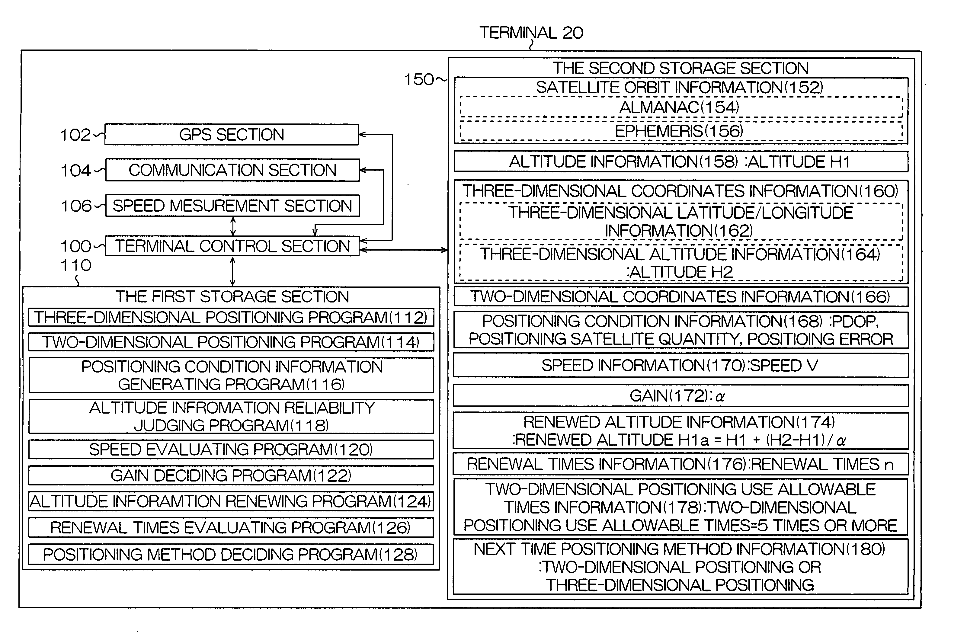
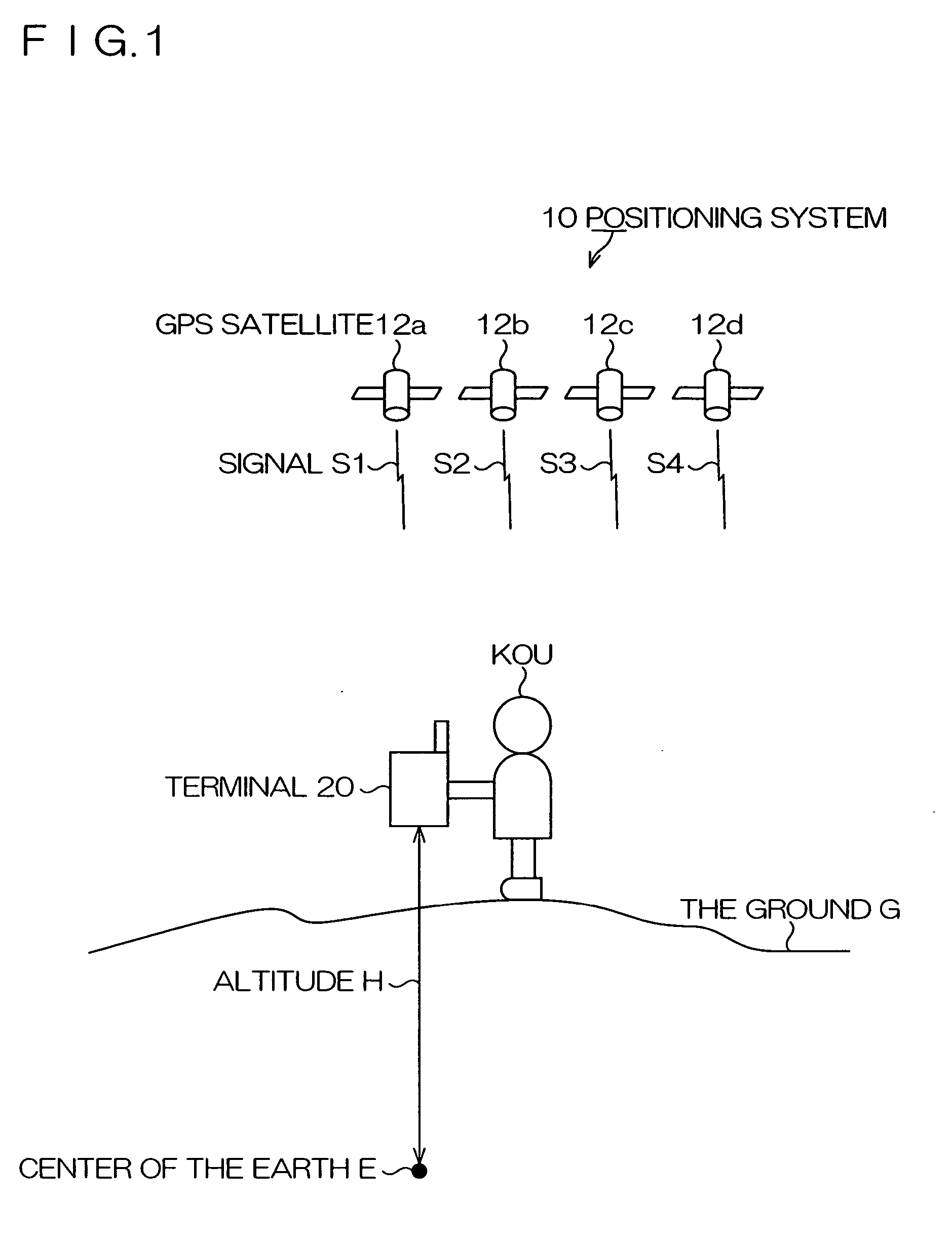
[0046]FIG. 1 is a schematic diagram showing a positioning system 10 according to an embodiment of the present invention.

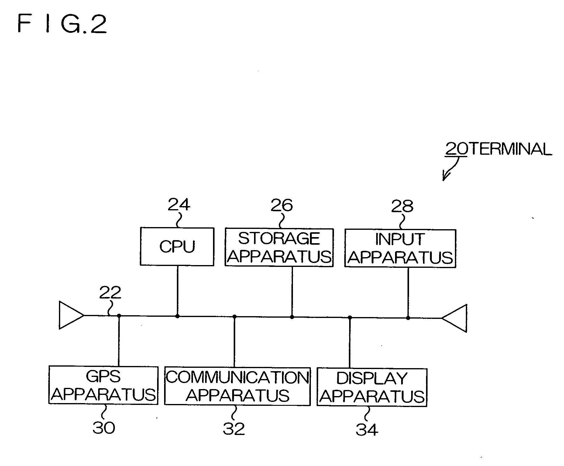
[0047] As shown in FIG. 1, the positioning system 10 has a terminal 20. The terminal 20 can receive signals S1, S2, S3 and S4, which are signals from GPS satellites 12a, 12b, 12c and 12d, which are positioning satellites, for example. The signals Sl and the like are examples of satellite signals. And, the terminal 20 is an example of the positioning device.

[0048] The terminal 20 is held by a user Kou and transfers on a gr...


PUM


Abstract

A positioning device includes: altitude information storing means; satellite signal receiving means; three-dimensional coordinate information generating means; positioning condition information generating means for generating positioning condition information indicating positioning condition when the three-dimensional coordinate information has been generated; reliability allowable range judging means for judging whether reliability of three-dimensional altitude information included in the three-dimensional coordinate information is within a predetermined reliability allowable range or not based on the positioning condition information; altitude information renewing means for renewing the altitude information by using the three-dimensional altitude information based on judging result of the reliability allowable range judging means; two-dimensional coordinate information generating; and positioning method deciding means for deciding whether to use the three-dimensional coordinate information generating means or to use the two-dimensional coordinate information generating means based on judging result of the renewal time evaluating means.

Description

[0001] This application claims the priorities benefit under 35 U.S.C.§ 119 of Japanese Patent Application No. 2005-151048 filed on May 24, 2005, which is hereby incorporated in its entirety by reference. BACKGROUND [0002] 1. Technical Field [0003] The present invention relates to a positioning device using signals from positioning satellites, a control method of the positioning device, a control program of the positioning device, and a computer readable recording medium recording the control program of the positioning device. [0004] 2. Related Art [0005] In the past, a positioning system for positioning a current position of a GPS receiver by using a satellite navigation system, such as GPS (Global Positioning System), has been put into practical use. [0006] The GPS receiver receives signals from a plurality of GPS satellites, and obtains a distance (hereinafter, referred to as pseudo-distance) between each GPS satellite and the GPS receiver by a difference (hereinafter, referred to...

Claims


Application Information

Patent Timeline
Patent Type & Authority Applications(United States)
IPC IPC(8): G01C21/00G01S19/42
CPCG01S19/42G01S19/39G01S19/396G01C5/00G01S19/14
Inventor MIZUOCHI, SHUNICHI
Owner SEIKO EPSON CORP
Why Eureka
Try Eureka