Geographic database with detailed local data

a technology of local data and geographic database, applied in the direction of navigation instruments, traffic control systems, instruments, etc., can solve the problems of unclear where to park and how to physically reach the desired destination, and how to reach the desired destination

Active Publication Date: 2007-05-24
HERE GLOBAL BV
View PDF7 Cites 82 Cited by
  • Summary
  • Abstract
  • Description
  • Claims
  • Application Information

AI Technical Summary

Benefits of technology

[0007] To address these and other objectives, the present invention includes a geographic database system comprised of a core database and one or more location (or local) databases. The core database includes data that represents the public road network in a geographic region. Each of the location databases includes data that represent facilities, such as business, stores, offices, or other places, some of which may be physically located away from the public road network and access to which requires travel on paths away from the public road network. Each of the facilities represented in the location databases is assigned a unique location reference code. The location reference code assigned to a facility is associated with data indicating the location of the facility and data from which a path connecting the facility to the public road network represented in the core database can be determined.
[0008] Accordi

Problems solved by technology

In some cases, it even may be unclear how to reach the desired destination from the street address.
In this case, a navigation system us

Method used


Image

  • Geographic database with detailed local data
  • Geographic database with detailed local data
  • Geographic database with detailed local data

Examples


Embodiment Construction

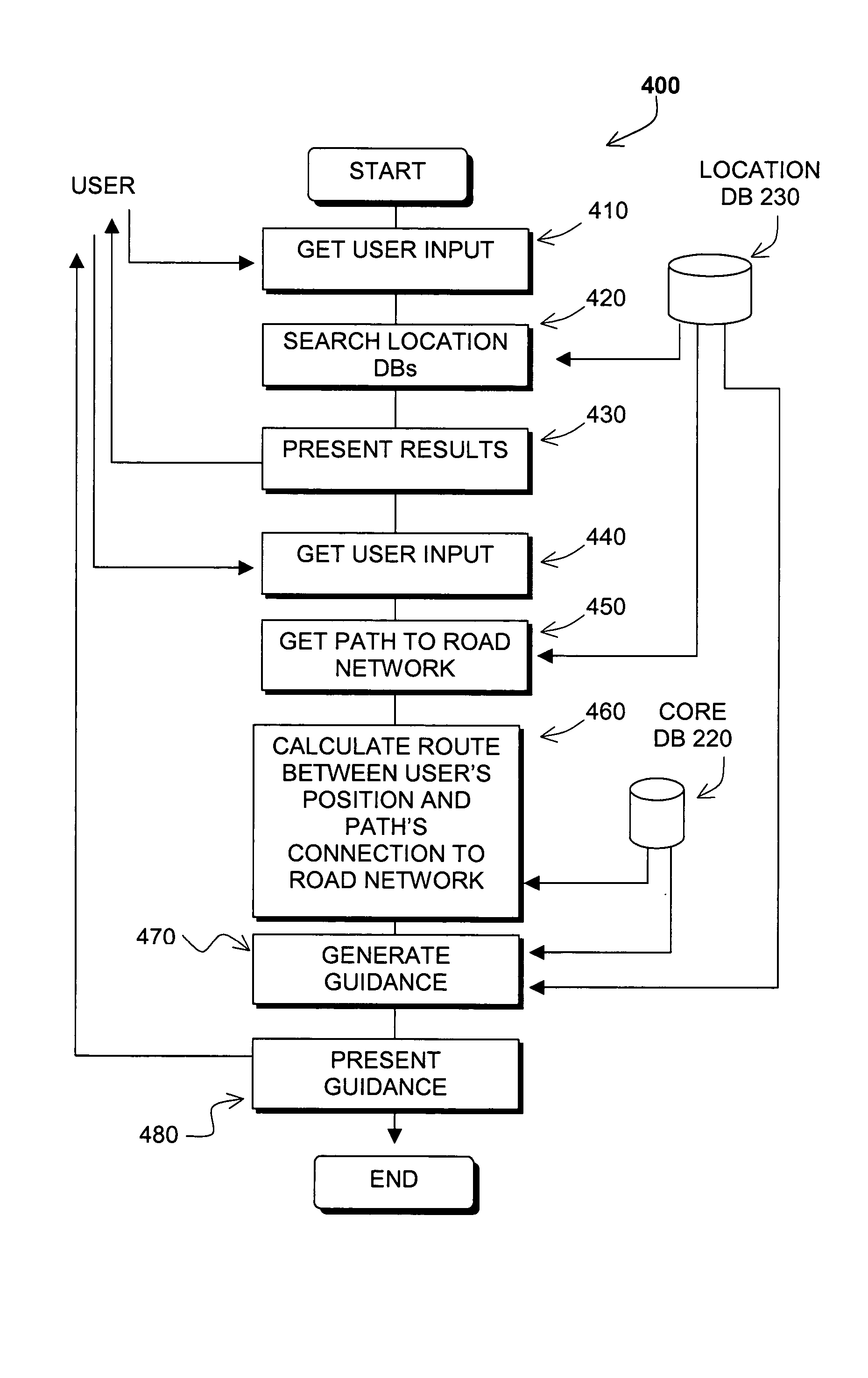
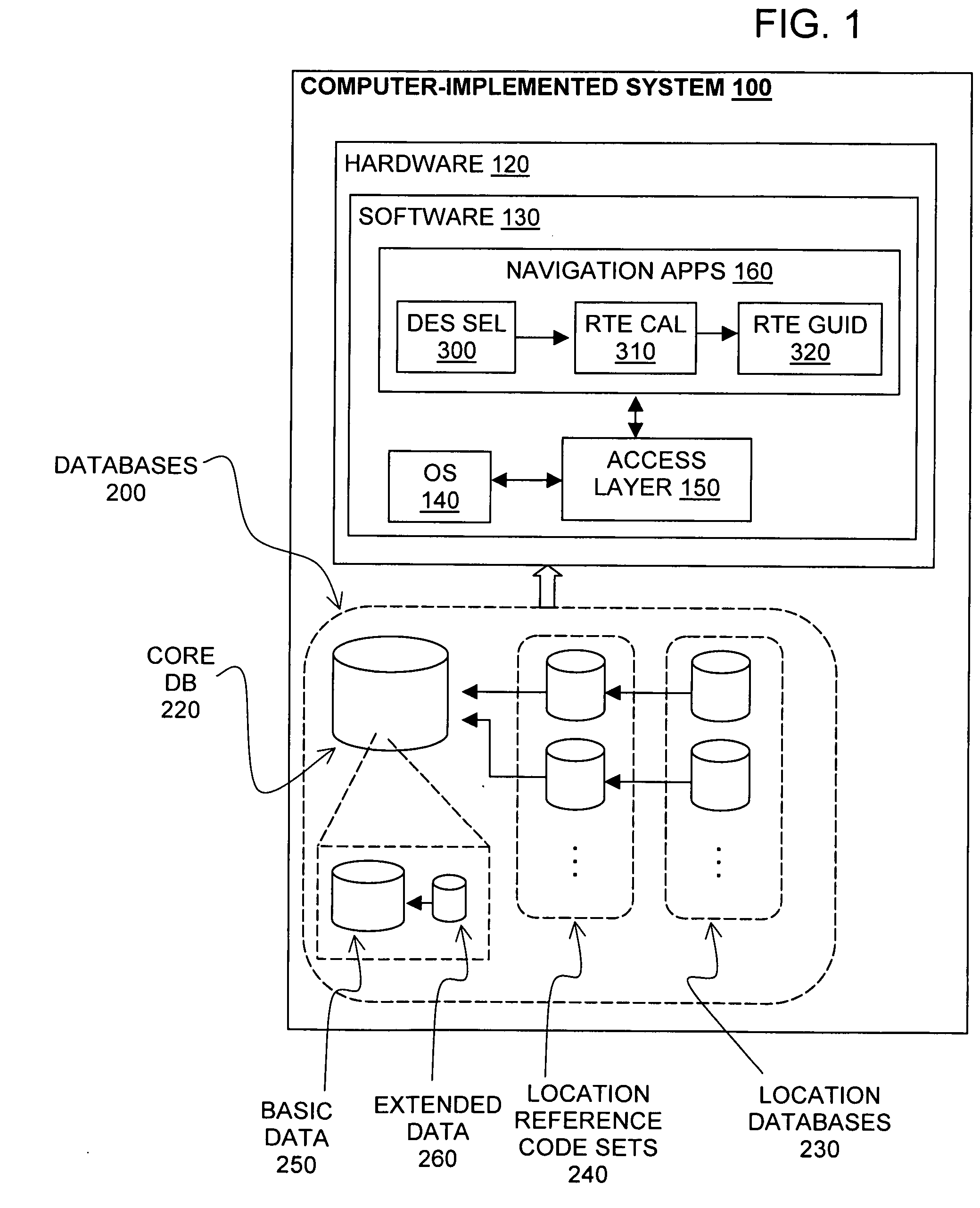
[0019]FIG. 1 shows general components of a system 100 for providing geographic and navigation-related information to users. The system 100 is a combination of computer hardware 120, software 130, and data. The computer hardware 120 includes memory, processor(s), data storage, and other necessary components. These may be conventional components. The software 130 includes an appropriate operating system 140, data access software 150 for accessing the data, and navigation- and / or map-related applications 160 for using the geographic data to provide meaningful information to users of the system. The software 130 may include other applications and / or programs. The software may be conventional, except as noted below.

[0020] The system 100 includes an appropriate user interface (not shown), including hardware and software that allow a user to input information into the system and receive information from the system. The user interface may include a monitor, keyboard, keypad, touch screen, ...


PUM


Abstract

A method is disclosed for representing locations in a geographic database in a manner that facilitates navigation and routing. A core map database includes data that represents public roads in a geographic region. Each of a plurality of location map databases includes data that represent facilities, such as businesses, stores, offices, or other places, that are physically located away from the public network and access to which requires travel on paths away from the public road network. Each of the facilities represented in the location map databases is assigned a location reference code that is associated with data from which a path connecting the facility and the public road network can be determined.

Description

BACKGROUND OF THE INVENTION [0001] The present invention relates to ways to represent locations to facilitate navigation and routing. [0002] There are various kinds of computer-based navigation and mapping systems that facilitate finding and routing to desired destinations. For example, navigation systems installed in vehicles provide useful information to vehicle drivers and passengers, including information for finding desired destinations, as well as route guidance information for driving to destinations. Similar features are available on portable (e.g., handheld) devices. Some of these types of portable devices can be used in vehicles, but can also be carried by pedestrians or by persons using other modes of transportation, such as trains, ferries, and so on. Navigation and routing information is also available from Internet sites. Navigation and routing information is also available on mobile phones. [0003] These systems and applications rely on data that represents the road ne...

Claims


Application Information

Patent Timeline
IPC IPC(8): G01C21/32
CPCG06F17/30241G06F16/29
Inventor FINN, MICHAELBORAK, JASONBENNETT, JAMES RONALD
Owner HERE GLOBAL BV
Why Eureka
Try Eureka