
Maps, routes and schedule generation based on historical and real-time data

Inactive Publication Date: 2007-06-07
DISCRETE WIRELESS
View PDF10 Cites 43 Cited by
  • Summary
  • Abstract
  • Description
  • Claims
  • Application Information

AI Technical Summary

Benefits of technology

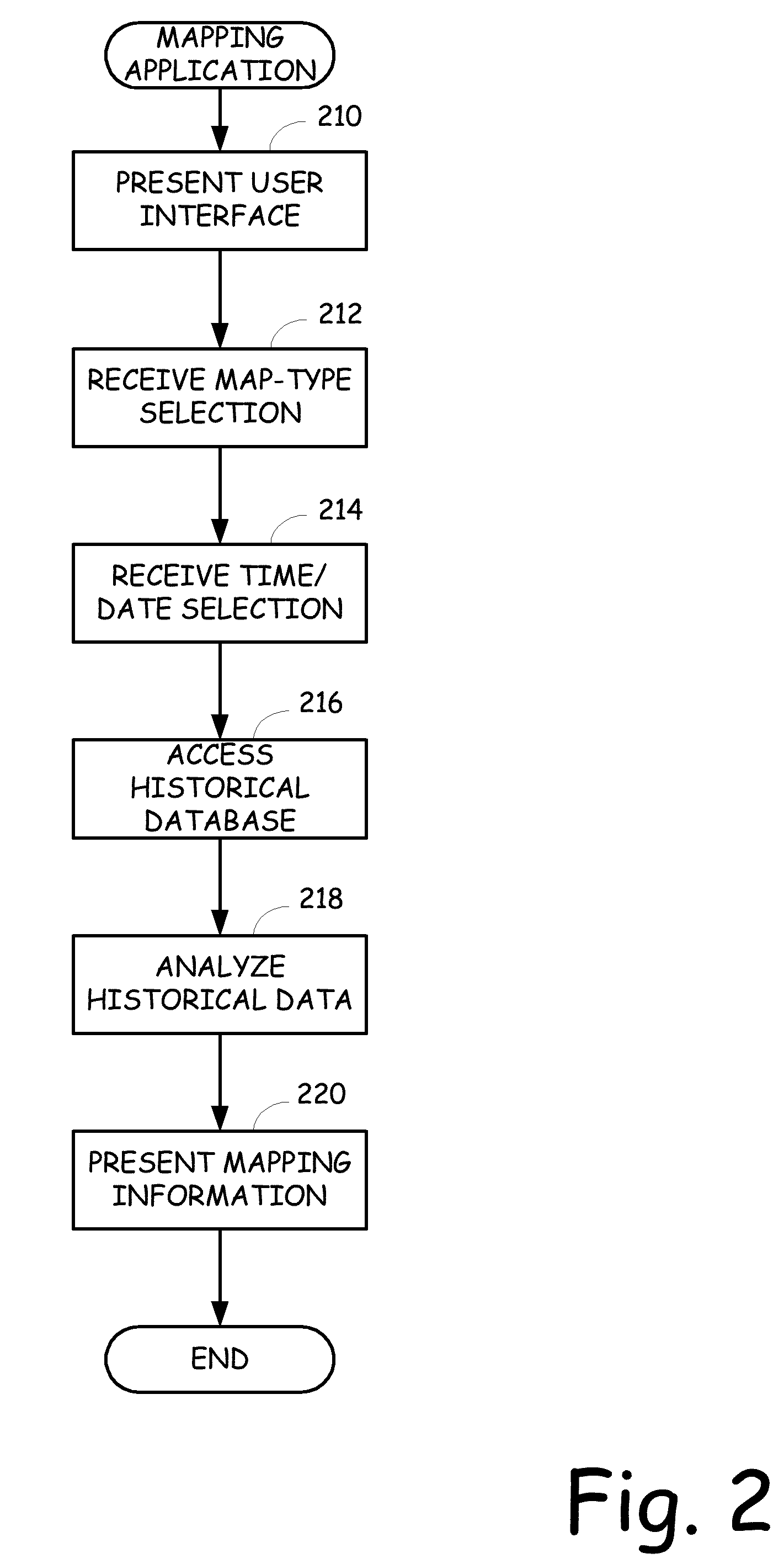
[0013]FIG. 2 is a flow diagram illustrating the high-level operation of an embodiment of the present invention.
[0014]FIG. 3 is a simplified exemplary output of two-point route generated for an embodiment of the invention that receives a time and date entry.
[0015]FIG. 4 is a simplified exemplary output of a two-point route generated for an embodiment of the invention that receives a time entry only, assumes

Problems solved by technology

Sure, you can still find these archaic items in the stores, but for the most part, they seem to be covered in several layers of dust.
However, these services do not provide accurate travel time predictions based on anything other than miles and posted speed limits.
Thus, as traffic patterns fluctuate, construction commences, accidents occur, etc., the accuracy of the travel times provided by these mapping services can be grossly inaccurate.
Thus, other than the few benefits listed herein (i.e., listing of sites and services available along the route), the high-technology map generation systems are not much more sophisticated than a good old reliable atlas or accordion map.

Method used


Image

  • Maps, routes and schedule generation based on historical and real-time data
  • Maps, routes and schedule generation based on historical and real-time data
  • Maps, routes and schedule generation based on historical and real-time data

Examples


Embodiment Construction

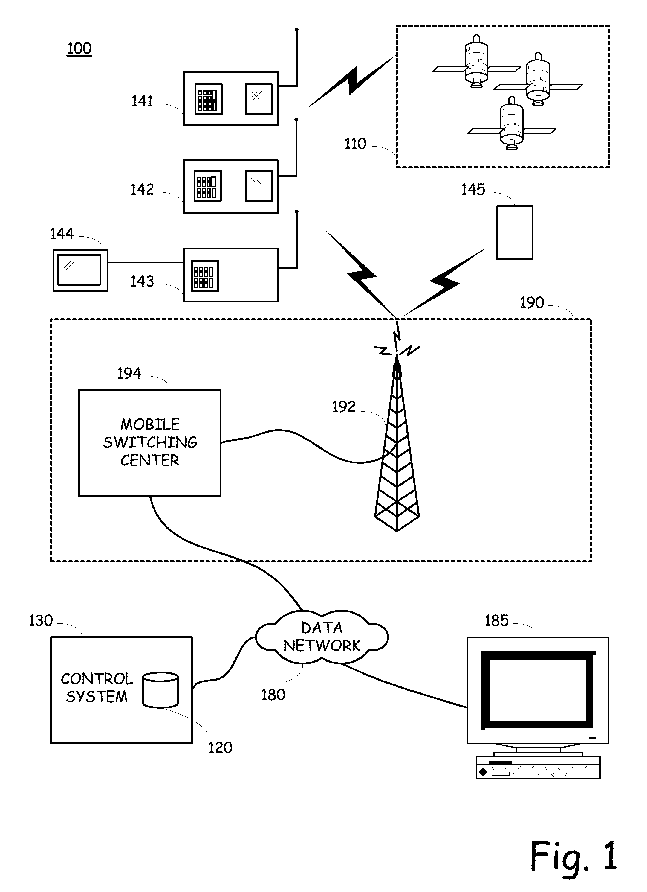
[0019] The present invention, among other things, operates to generate mapping information for a user based on historical data that is relevant to the time, date and location pertaining to the requested mapping information. Furthermore, the user can receive updated information from real-time systems, such as traffic probes, to augment the mapping information.

[0020] More specifically, the present invention is a computer-based or web-based application that enables a user to generate mapping information that includes accurate travel time and alternate routing information based on historical information and / or real-time information. One aspect of the present invention is the generation of time / date relative mapping information. Advantageously, this aspect of the present invention allows a user to generate a map that will show expected routing and travel times based on expected conditions at a particular time and / or date. Another aspect of the present invention is the generation of real...


PUM


Abstract

Mapping information can be generated and provided to a user to identify preferred routes and estimated travel times to traverse the preferred routes. The mapping information is initially generated based on mapping data obtained in a historical database. The mapping data can be retrieved based on the routes, the time and the date information. Thus, the preferred routes and travel times are identified and determined based on historical information, as well as distance and speed limit information. In addition, real-time information can be received from various sources, analyzed and then provided to a user to augment or update the mapping information.

Description

CROSS-REFERENCE TO RELATED APPLICATIONS [0001] The present invention is a continuation-in-part of United States application for patent filed on Dec. 1, 2005 with a title of “GEO-FENCE LOCATION-SPECIFIC EQUIPMENT STATUS BASED TRIGGER DIRECTED CONTENT DELIVERY” and assigned Ser. No. 11 / 164,679. [0002] This application is related to the following United States patent applications which were filed concurrently herewith and are incorporated herein by reference in their entirety: [0003] Ser. No. 11 / ______ filed on ______, 2006 with a title of ______, and [0004] Ser. No. 11 / ______ filed on ______, 2006 with a title of ______.BACKGROUND OF THE INVENTION [0005] This invention relates to the fields of location devices and systems, and distributed geocentric location based systems and their application to cartography and, more particularly to utilizing historically collected data as well as real-time date from geocentric location based systems to generate accurate maps, along with routes and s...

Claims


Application Information

Patent Timeline
IPC IPC(8): G01C21/32
CPCB60W2550/402G01C21/26H04W4/02H04W4/027H04W4/028H04W4/20H04L67/12H04L67/18H04W4/029H04W4/024B60W2556/50H04L67/52
Inventor THACHER, JEFFERY W.
Owner DISCRETE WIRELESS
Learn More