Map database having address points for determining destinations

a database and address technology, applied in the field of map databases, can solve the problems of not being able to and the house numbers may be distributed along the block non-uniformly, not always the case, and no interpolation algorithm can account for variations in the real world distribution of buildings or house numbers along a given street block

Inactive Publication Date: 2007-08-09
TELE ATLAS NORTH AMERICA
View PDF8 Cites 41 Cited by
  • Summary
  • Abstract
  • Description
  • Claims
  • Application Information

AI Technical Summary

Benefits of technology

[0008] In one aspect, the invention is a map database storable on a storage medium that includes at least one street segment. The street segment may have zero or more address ranges corresponding to the house or building numbers on that segment. The street segment may also have zero or more address points, each corresponding to the position of a building, house number or address range within the address range of the street segment.

Problems solved by technology

However, no interpolation algorithm can account for variations in the real world distribution of buildings or house numbers along a given street block.
For example, there may be a park at the beginning or in the middle of the block, houses may be distributed along the block non-uniformly, or buildings at the ends of address ranges may not be located exactly at street intersections.
However, this is not always the case.
Some map databases are modeled with address ranges using potential building or house numbers at the end points, and this exacerbates the problem of accurately interpolating intermediate building or house numbers.
As an example, in downtown New York City, where streets are broken up into blocks of 100 address numbers, building or house numbers along a block side seldom represent the entire address range and often fall short of completing the range at one end or the other.
Interpolation using the above methods may have errors of fifty percent or more of the length of the street segment.
These interpolation errors can translate into tens or hundreds of meters of error, for example, possibly making a desired place out of a user's range of sight for a user who has navigated to the interpolated location.
While interpolation delivers the most precise location the above methods support, it does not guarantee high sub-block accuracy.

Method used


Image

  • Map database having address points for determining destinations
  • Map database having address points for determining destinations
  • Map database having address points for determining destinations

Examples


Embodiment Construction

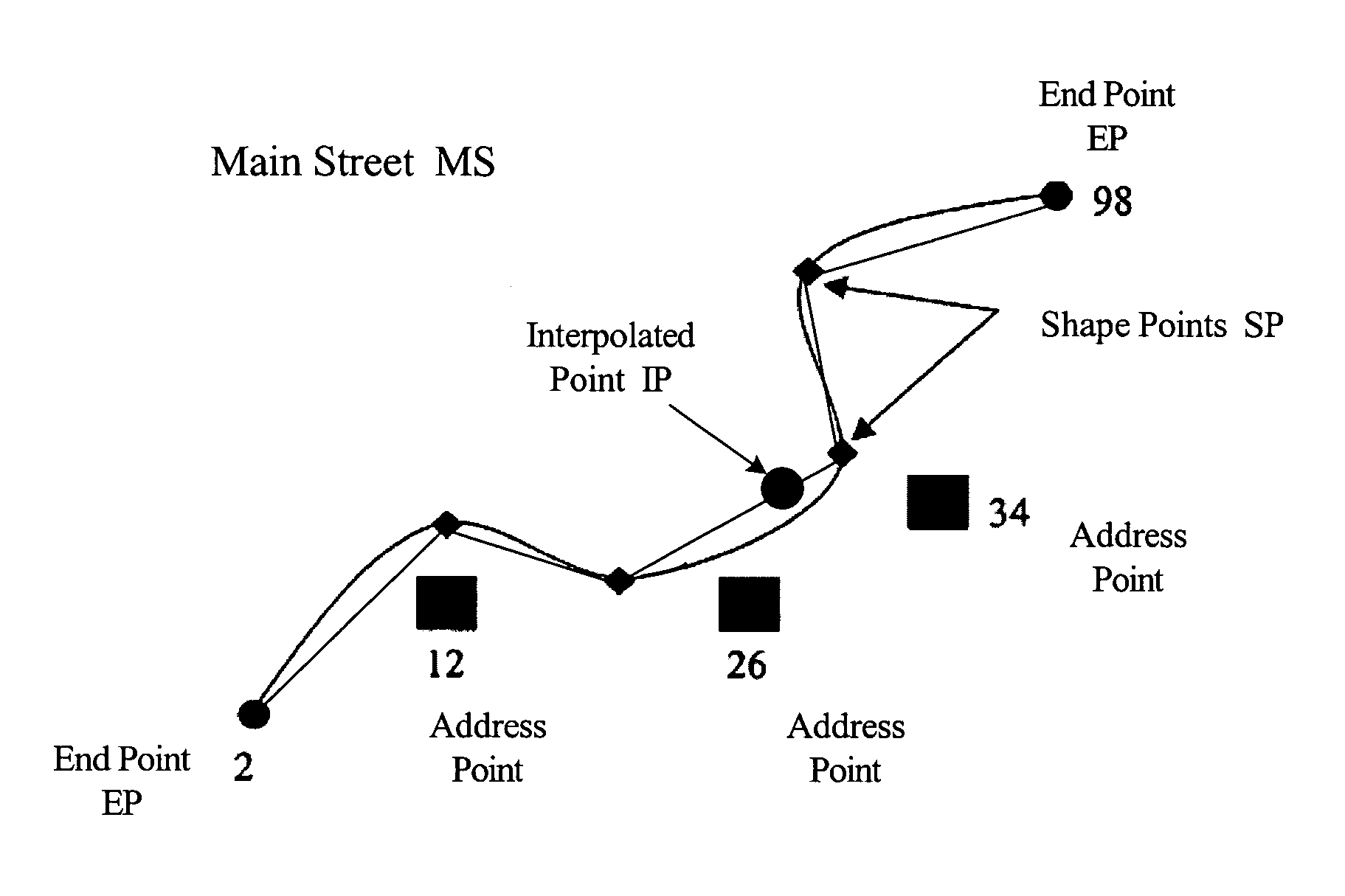
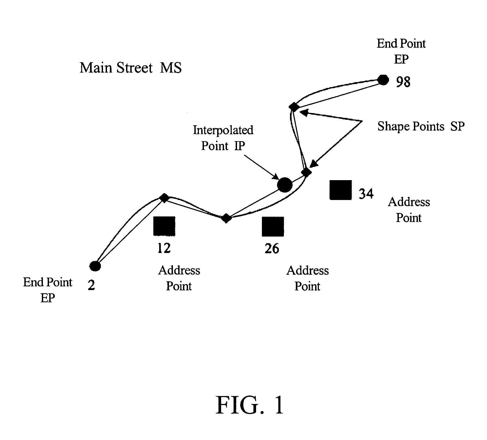
[0021]FIG. 1 is a schematic illustration of a street segment of one side of one block of a hypothetical Main Street MS of a given city and a piecewise linear representation of the street segment formed by drawing straight lines between specific points, called shape points SP, along the segment. For this example, assume that this segment of Main Street MS is a residential street having house numbers in an address range of 2-98. The curving line of the street segment represents what would be real-world curves of Main Street MS if Main Street MS was a real street. At the ends of the street segment are end points EP at house number 2 and house number 98. Associated with these end points EP are latitude and longitude coordinates. Additionally, shape points SP are shown along the street segment that are intermediate points used to define the curvature of the segment. Straight lines are used to form a piecewise-linear representation of the real-world curves of the street segment by connect...


PUM


Abstract

A user is given location information of a desired place, by providing a map database having an index of street segments, each having one or more street names, zero or more shape points and zero or more address points, the points representing specific positions along a street segment, the address points associated with a house number or address range. A user enters a street address of the desired place into device application software, which returns the location to the user if the desired place is an address point. Otherwise, interpolate the location by finding low and high addresses such as the two closest bracketing addresses from address points, or from one address point and from a street segment end point. The interpolated location will be between the low and high addresses by piece-wise linear interpolation, following the street segment's shape points and is then returned to the user.

Description

FIELD OF THE INVENTION [0001] The present invention relates to map databases having information for determining locations of specific addresses and, more particularly, to map databases having a data structure that is used for accurately determining the positions or locations of places desired by a user. BACKGROUND OF THE INVENTION [0002] In recent years, consumers have been provided with a variety of devices and systems to enable them to locate places on a digital map. The term “place” is a general term used throughout the description of this invention. The term “place” includes street addresses, buildings located at street addresses such as businesses and landmarks, and facilities located at a number of street addresses such as shopping malls and business parks. The variety of devices and systems used by consumers are in the form of in-vehicle navigation systems that enable drivers to navigate over streets and roads, hand-held devices such as personal digital assistants (“PDAs”), p...

Claims


Application Information

Patent Timeline
Patent Type & Authority Applications(United States)
IPC IPC(8): G01C21/32
CPCG01C21/32G09B29/106G06F17/30241G01C21/367G06F16/29G01C21/3811
Inventor GEILICH, MICHAEL
Owner TELE ATLAS NORTH AMERICA
Why Eureka
Try Eureka