Airborne Situational Awareness System

a situational awareness and airborne technology, applied in the field of radio frequency transmission systems, can solve the problems of limited range accuracy, insufficient target resolution, and well-known limitations of radars

Inactive Publication Date: 2007-09-27
DIMENSIONAL RES
View PDF34 Cites 109 Cited by
  • Summary
  • Abstract
  • Description
  • Claims
  • Application Information

AI Technical Summary

Benefits of technology

[0007] Embodiments of the present invention are directed to a digital airborne situational awareness system and method. The digital airborne situational awareness system includes integrated electronic hardware modules and software. The installation of the system on multiple aircraft makes an airborne digital network possible, thereby providing collision avoidance without ground control. A global positioning system (GPS) receiver unit is coupled to a microprocessor in each aircraft equipped with the system. The software receives the raw GPS data and determines location, speed, flight path direction, and altitude. The software conditions the raw GPS data for proper display on a cockpit display panel. The conditioned data orients the display with the heading, speed, and altitude data of the host system aircraft. A transceiver section provides data transmission to other airborne receiving units within the approximately forty mile range of the airborne digital network.
[0009] In an exemplary embodiment, the software develops a set of projections that is compared to the relative speed, flight path direction and altitude of all the participating units in the airborne network. These projections will determine the threat levels of converging flight paths with limits that provide warning data to the pilot of any pending flight path conflict situation. The situational awareness system includes the capability of unmanned aerial vehicles being programmed to react to this data for autonomous flight path deviation, enabling such vehicles to deviate from pending flight path conflicts.

Problems solved by technology

Radar has well-known limitations including limited range accuracy and insufficient target resolution at a critical, near-collision state when two aircraft are close together.
This system issues numerous false alarms and / or erroneous commands or instructions, which may actually increase the probability of collision.
Furthermore, the existing TCAS system cannot detect a collision danger with an aircraft that does not have a functional pressure altimeter.

Method used


Image

  • Airborne Situational Awareness System
  • Airborne Situational Awareness System
  • Airborne Situational Awareness System

Examples


Embodiment Construction

[0024] The following description of the invention is provided as an enabling teaching of the invention and its best, currently known embodiment. Those skilled in the relevant art will recognize that many changes can be made to the embodiments described, while still obtaining the beneficial results of the present invention. It will also be apparent that some of the desired benefits of the present invention can be obtained by selecting some of the features of the present invention without utilizing other features. Accordingly, those who work in the art will recognize that many modifications and adaptations to the present invention are possible and may even be desirable in certain circumstances, and are a part of the present invention. Thus, the following description is provided as illustrative of the principles of the present invention and not in limitation thereof, since the scope of the present invention is defined by the claims.

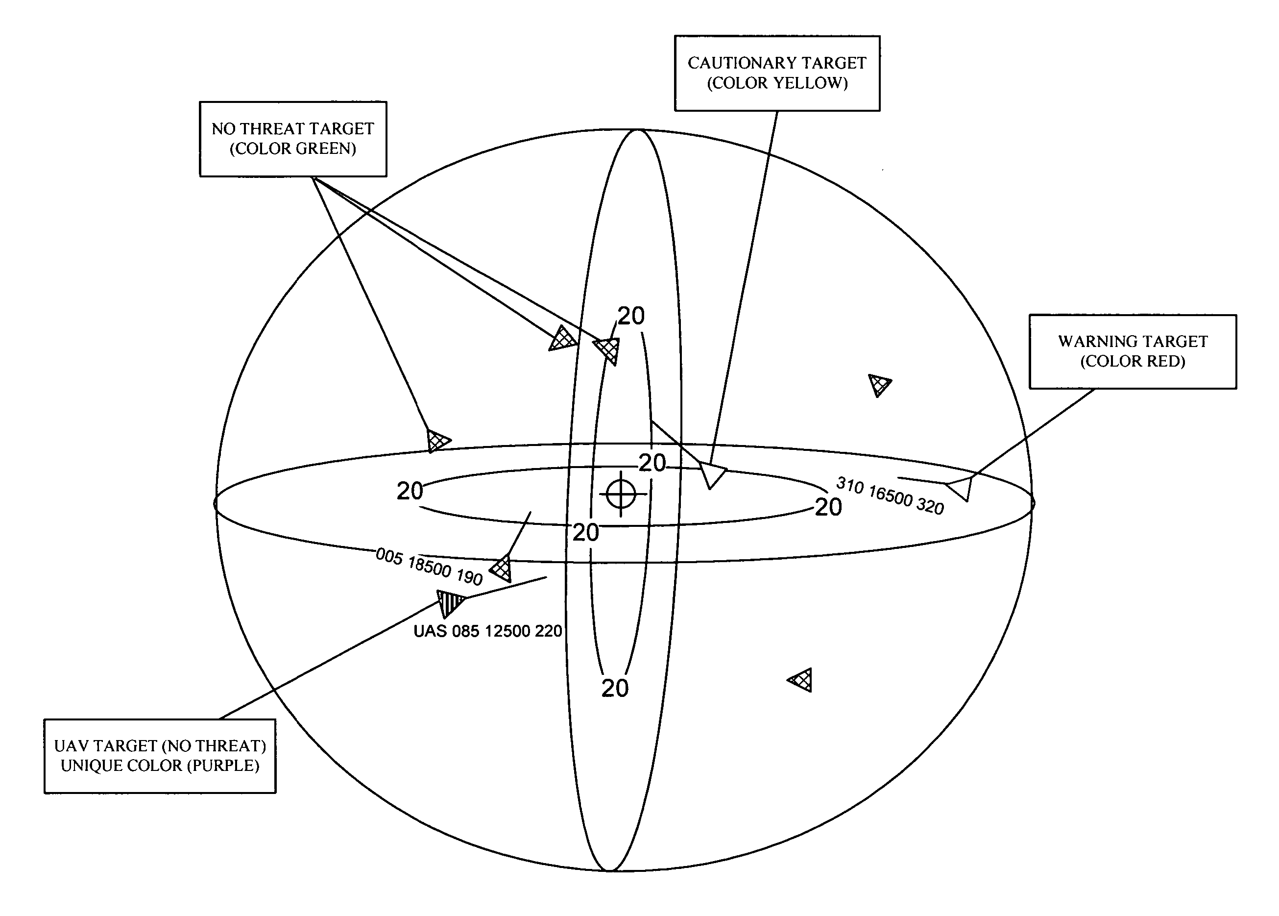
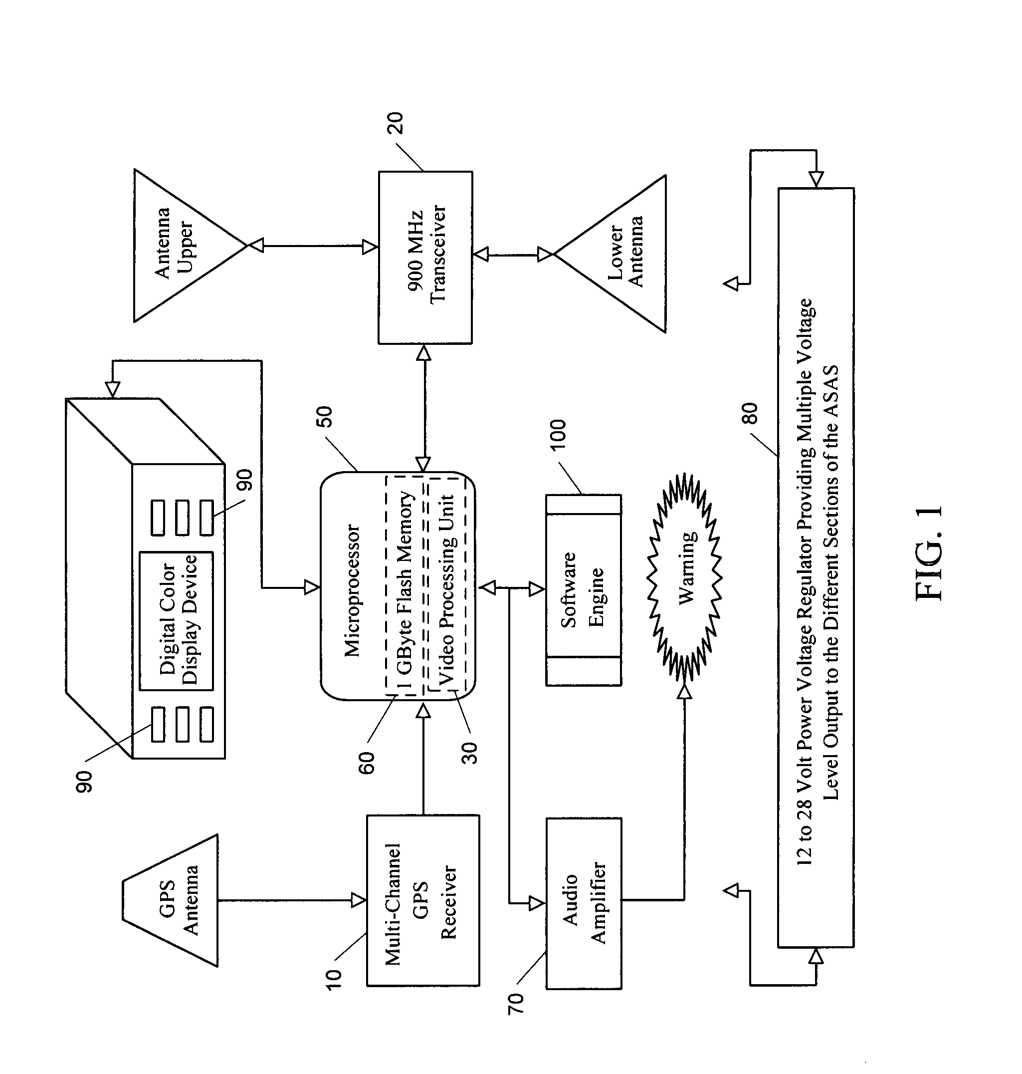
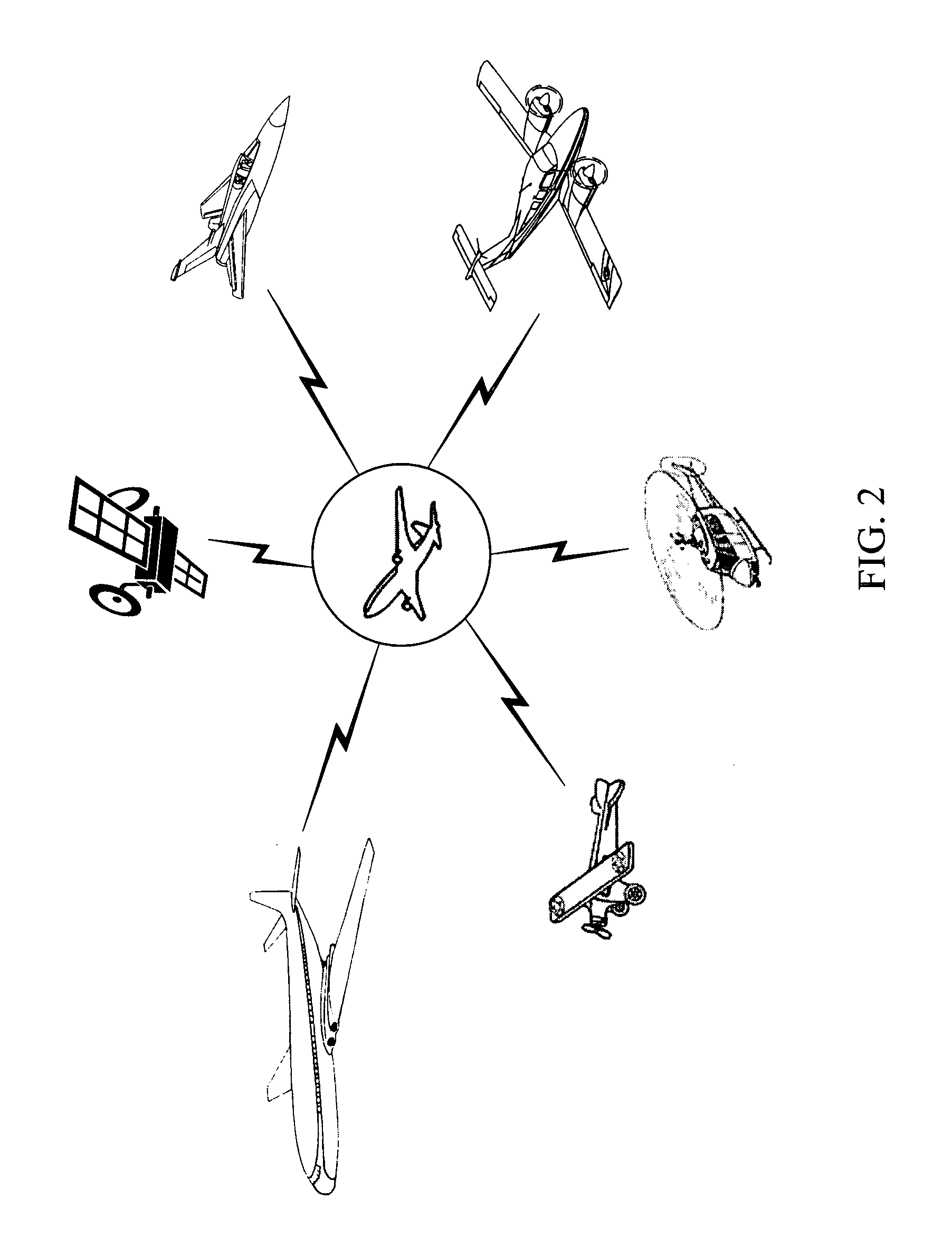
[0025] The Airborne Situational Awareness System (ASA...


PUM


Abstract

A digital airborne situational awareness system and method. The system is installed on multiple aircraft to generate an airborne network providing collision avoidance without ground control. A global positioning system (GPS) receiver unit is coupled to a microprocessor in each aircraft equipped with the system. A software engine receives the raw GPS data and determines location, speed, flight path direction, and altitude. The software engine conditions the GPS data for display on a cockpit display panel. The conditioned data orients the display with the heading, speed, and altitude data of the host system aircraft. A transceiver section provides data transmission to other airborne receiving units within the approximately forty mile range of the airborne network. The transceiver transmits data packets including reconditioned location (track), altitude, and an aircraft class identifier to other aircraft in the network. The transceiver receives data from other airborne vehicles equipped with the system within the network range. Once the computations of positional data for other aircraft are performed, the positional data is sent to the display processing section for appropriate cockpit display. The software engine develops a set of projections that are compared to the relative speed, flight path direction and altitude of the all other units in the airborne network. These projections determine the threat levels of converging flight paths with limits that provide warning data to the pilot of any pending flight path conflict situation.

Description

CROSS-REFERENCE TO RELATED APPLICATION [0001] This patent application claims the benefit of a provisional patent application entitled “Airborne Situational Awareness System,” filed on Mar. 7, 2006 as U.S. patent application Ser. No. 60 / 779,820 by the inventor named in this patent application. The specification and drawings of the provisional patent application are specifically incorporated herein by reference.BACKGROUND OF THE INVENTION [0002] The present invention relates generally to radio frequency transmission systems and, more particularly, to aircraft location, identification and collision avoidance systems for manned, remotely-piloted and autonomous unmanned aircraft. [0003] There are numerous prior art aircraft location, identification and collision avoidance systems and generally the systems are under control of ground control facilities such as enroute air traffic controllers and airport flight operations control. Such systems rely on radar and two-way voice radio communic...

Claims


Application Information

Patent Timeline
Patent Type & Authority Applications(United States)
IPC IPC(8): G01S13/93G08G5/04G01S19/14G01S13/933G01S19/49
CPCG01S13/9303G01S19/18G08G5/0078G08G5/0021G08G5/0008G01S13/933
Inventor KOENEMAN, ROBERT L.
Owner DIMENSIONAL RES
Why Eureka
Try Eureka