Adaptive route planning for gps-based navigation

a global positioning system and navigation system technology, applied in the direction of navigation, instruments, surveying and navigation, etc., can solve the problems of not being able to adequately address the ability of the map, not being able to really help driving in a familiar locale, and not being able to adapt to the needs of the map

Inactive Publication Date: 2007-11-22
IBM CORP
View PDF9 Cites 23 Cited by
  • Summary
  • Abstract
  • Description
  • Claims
  • Application Information

AI Technical Summary

Benefits of technology

[0006]Once sufficient information is established in the database, the user can supply and the system can receive, as input, a beginning and an end of a desired route (e.g., a new route). The then current day and time is also supplied or known by the GPS based navigation system. From the historical records within the database of the different actual travel times for the different route segments, the method can then calculate a plurality of potential travel routes between the beginning and end of the desired route (each of the potential travel routes comprises the route segments stored in the database). Subsequently, the method calculates an estimated travel time for each of the different potential travel routes using the actual historical time of travel of the route segments for the current day and time. The calculating of the estimated travel time comprises adding stored actual travel times for all route segments within each of the potential travel routes. Then the method can identify a travel route that has a shortest estimated travel time for the current day and time to allow the user to know the fastest route that will be available for the current day and time.

Problems solved by technology

The resulting route chosen is adequate, but not necessarily the best.
There are many factors that could be used to improve route planning, but are currently beyond the ability of the map makes to adequately address, such as time of day, day of the week, local traffic patterns, number and length of traffic light, etc.
GPS based navigation is great for getting to someplace new, but not really much help driving in a familiar locale.

Method used


Image

  • Adaptive route planning for gps-based navigation
  • Adaptive route planning for gps-based navigation
  • Adaptive route planning for gps-based navigation

Examples


Embodiment Construction

[0011]The present invention and the various features and advantageous details thereof are explained more fully with reference to the non-limiting embodiments that are illustrated in the accompanying drawings and detailed in the following description. It should be noted that the features illustrated in the drawings are not necessarily drawn to scale. Descriptions of well-known components and processing techniques are omitted so as to not unnecessarily obscure the present invention. The examples used herein are intended merely to facilitate an understanding of ways in which the invention may be practiced and to further enable those of skill in the art to practice the invention. Accordingly, the examples should not be construed as limiting the scope of the invention.

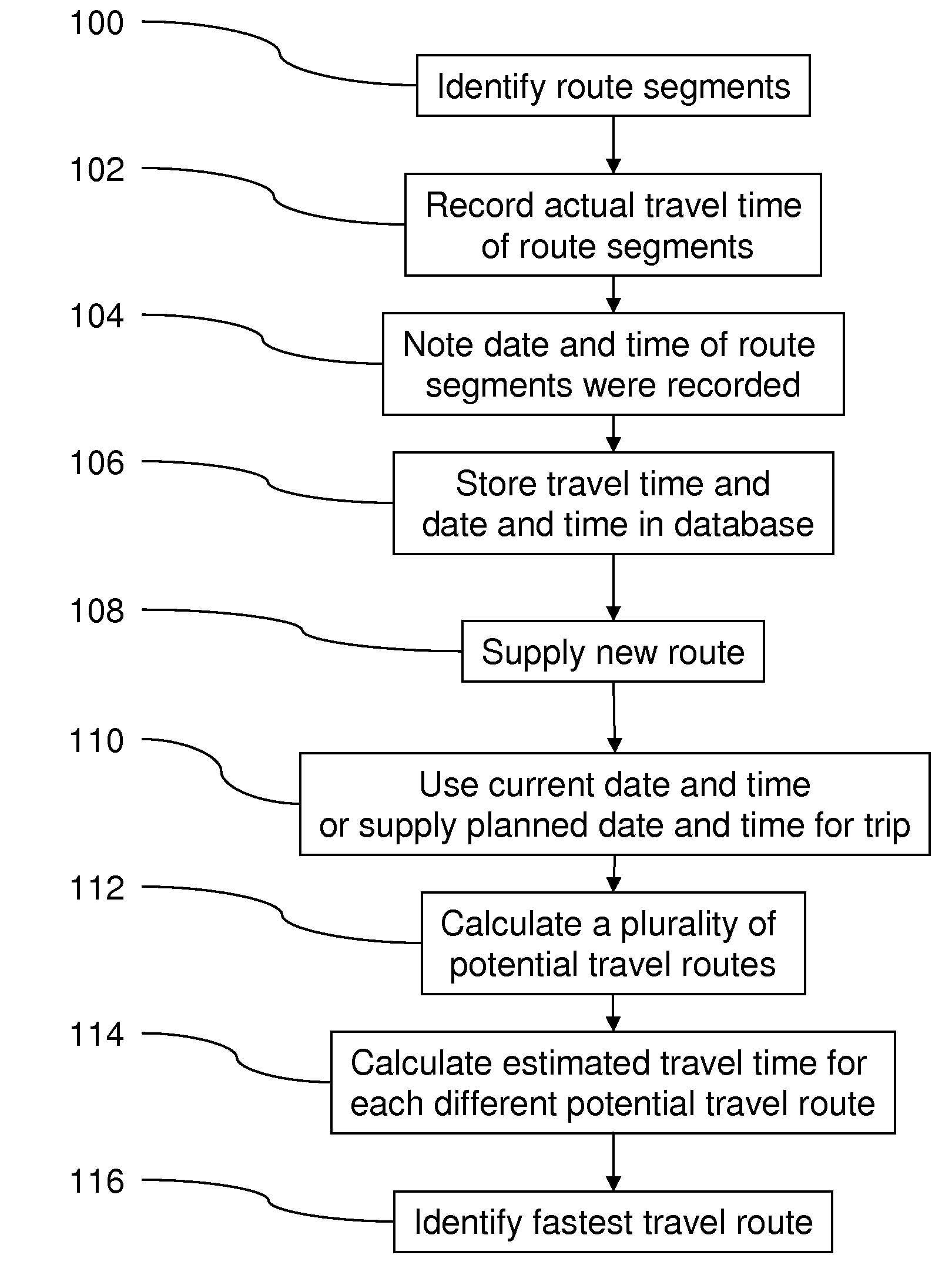
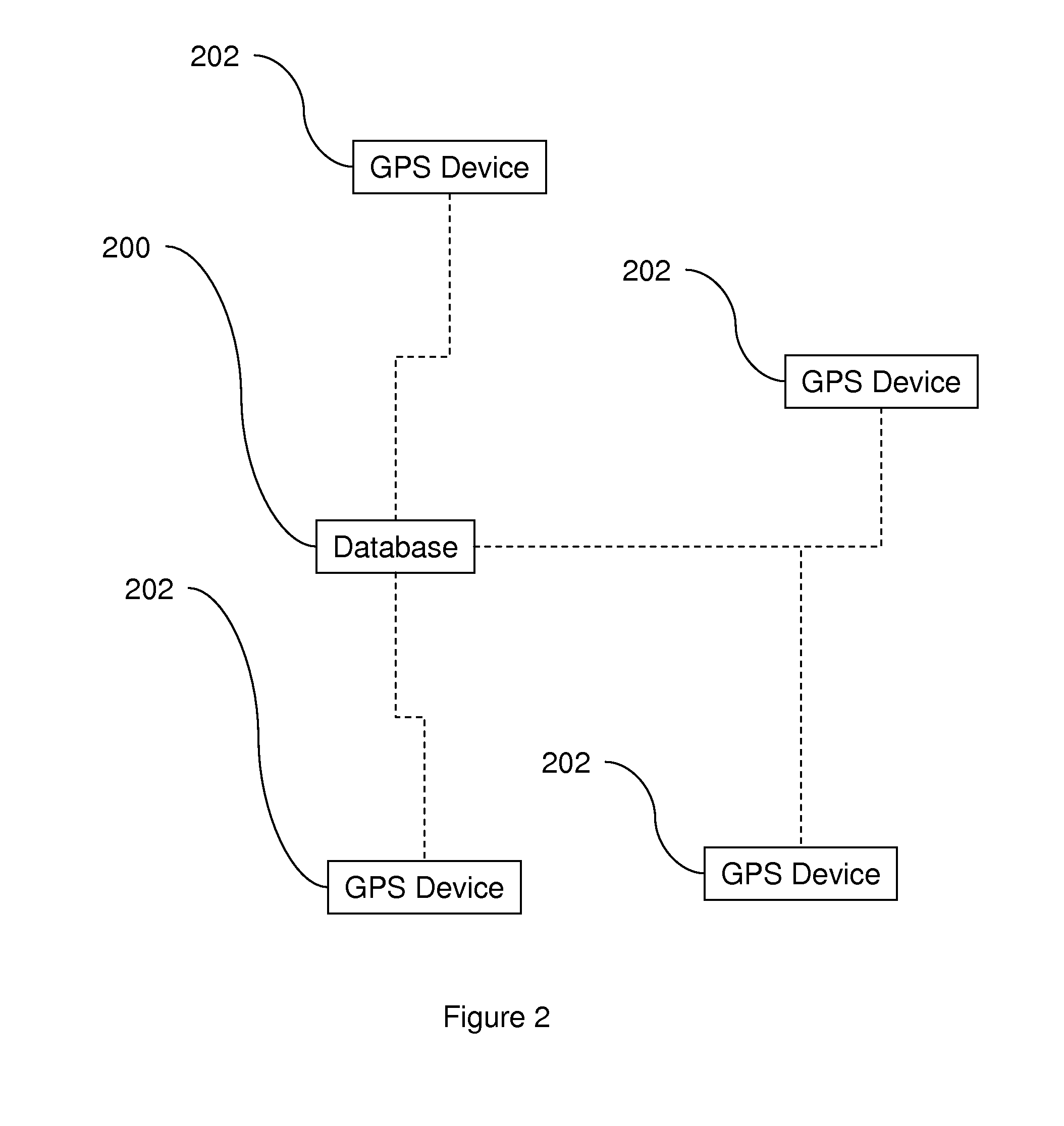
[0012]This invention comprises an adaptive route planning system where the GPS system monitors driving and builds a database of the actual historical time to traverse any road segment and the time of day and day of the week...


PUM


Abstract

Disclosed herein is a method of route planning for global positioning system (GPS) based navigation systems. The method identifies route segments used in a GPS based navigation system and records an actual historical time of travel for at least one route segment traveled by users of the GPS based navigation system travel. The actual historical time of travel comprises the amount of time taken by a user of the GPS based navigation system to go from a beginning of the route segment to an end of the route segment. With embodiments herein, the day and time that the route segment was recorded is also noted. Then, the actual historical time of travel and the day and time for the route segment can be stored in a database. This information can be stored for a single-user or can be combined from a plurality users of the GPS based navigation systems.

Description

BACKGROUND OF THE INVENTION[0001]1. Field of the Invention[0002]The invention generally relates to a method of route planning for global positioning system (GPS) based navigation systems and more particularly to a method that identifies route segments used in a GPS based navigation system and records an actual historical time of travel for at least one route segment traveled by users of the GPS based navigation system.[0003]2. Description of the Related Art[0004]GPS based navigation systems available today use stored maps to do route planning based on distance, speed limits and user preference of types of roads. The resulting route chosen is adequate, but not necessarily the best. For example, see U.S. Patent Publication 2006 / 0031566 (which is incorporated herein by reference)that discloses a GPS system that uses a Vehicle Information and Communication System (VICS), in which real time traffic information is transmitted to users to allow the GPS system to determine the shortest-rout...

Claims


Application Information

Patent Timeline
Patent Type & Authority Applications(United States)
IPC IPC(8): G01C21/34
CPCG01C21/3492
Inventor PERRY, PATRICK E.
Owner IBM CORP
Why Eureka
Try Eureka