Storage and visualization of points of interest in a navigation system

a navigation system and point of interest technology, applied in the field of route guidance by a navigation system, can solve the problems of system not being able to be manipulated by the user to add new pois, system cannot be adapted to the individual needs of the user, and providing the driver with standardized non-individualized information

Active Publication Date: 2008-01-31
HARMAN BECKER AUTOMOTIVE SYST
View PDF8 Cites 55 Cited by
  • Summary
  • Abstract
  • Description
  • Claims
  • Application Information

AI Technical Summary

Benefits of technology

[0010] A navigation system permits a driver to navigate using a digital map, which indicates the position of the vehicle relative to the map. The navigation system also displays various POIs using icons, graphic indicia and / or alphanumeric indicators. An audio indicator may also be issued to alert the driver regarding an approaching point of interest. The navigation system also allows the driver to enter a new point of interest while in route. The coordinates of the new point of interest and an icon selected by the driver corresponding to the new point of interest are saved in a database. During a subsequent trip, when the driver approaches the previously saved point of interest, the navigation system may alert the driver of the approaching point of interest.
[0012] Further, the navigation system may save multiple POIs in the database, and similar POIs may be organized into a class of points of interest. The navigation system may also save multiple classes of points of interest while the user is navigating.

Problems solved by technology

However, existing navigation systems only provide the driver with standardized non-individualized information or with a preset customized route.
The systems cannot be manipulated by the user to add new POIs once the trip has begun.
The systems cannot be adapted to the individual needs of the user in route.

Method used


Image

  • Storage and visualization of points of interest in a navigation system
  • Storage and visualization of points of interest in a navigation system
  • Storage and visualization of points of interest in a navigation system

Examples


Embodiment Construction

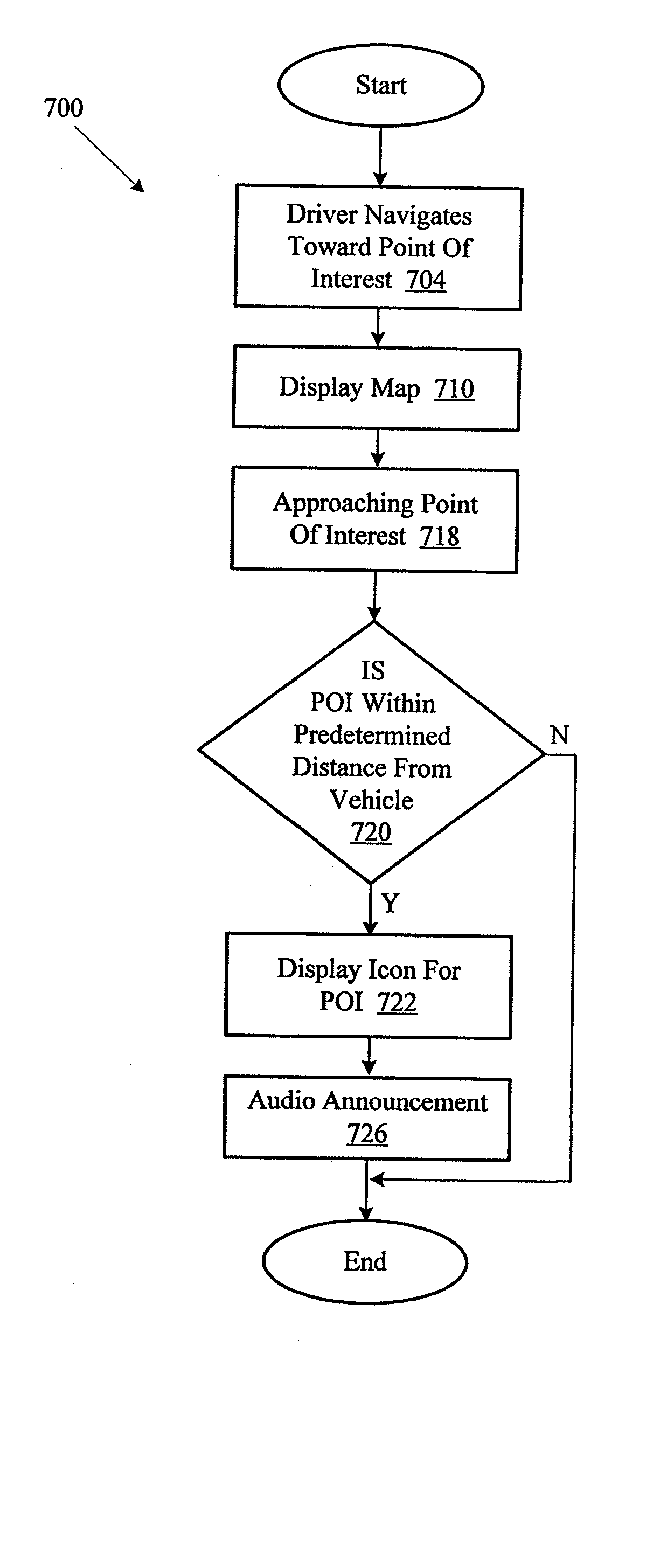
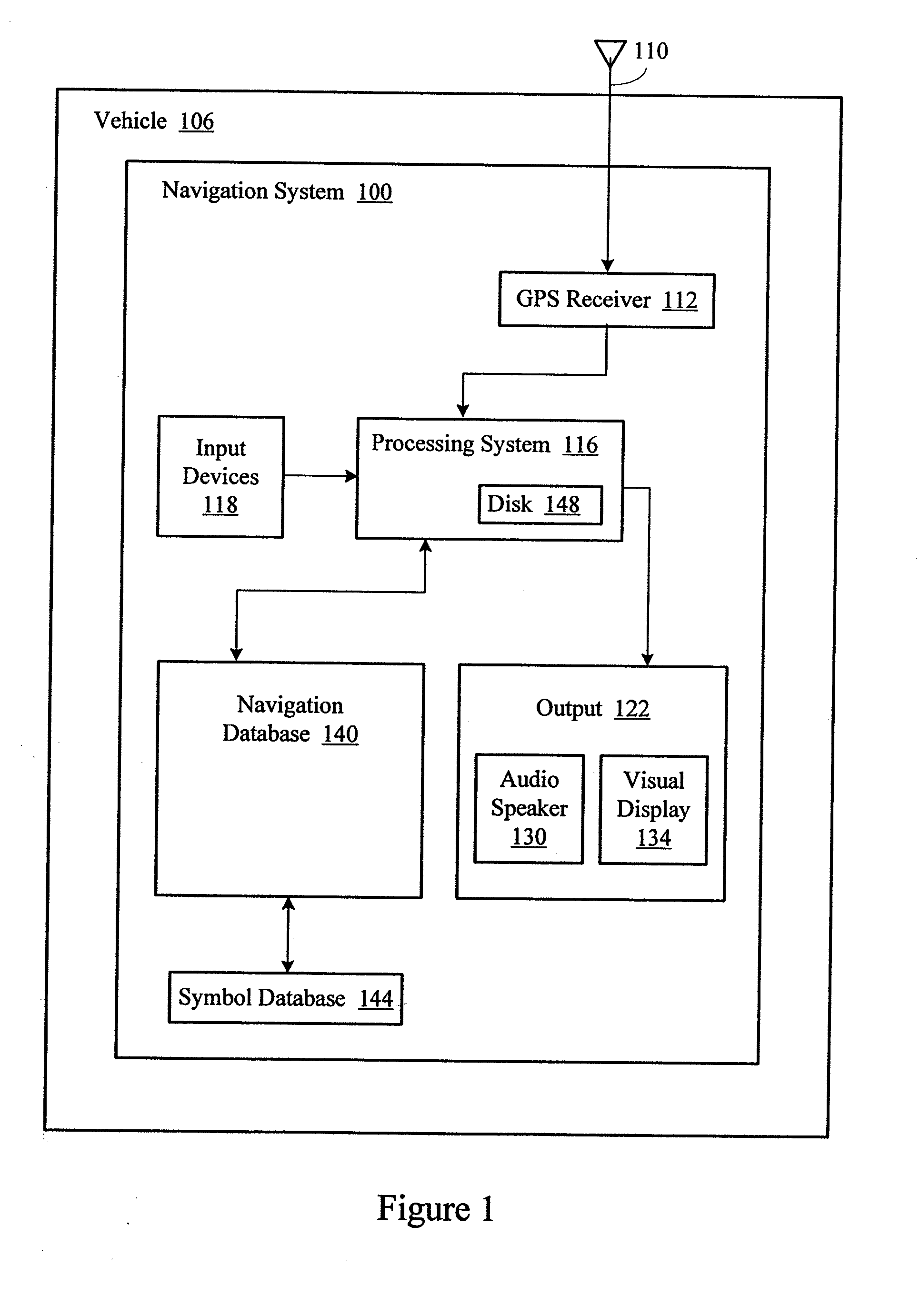
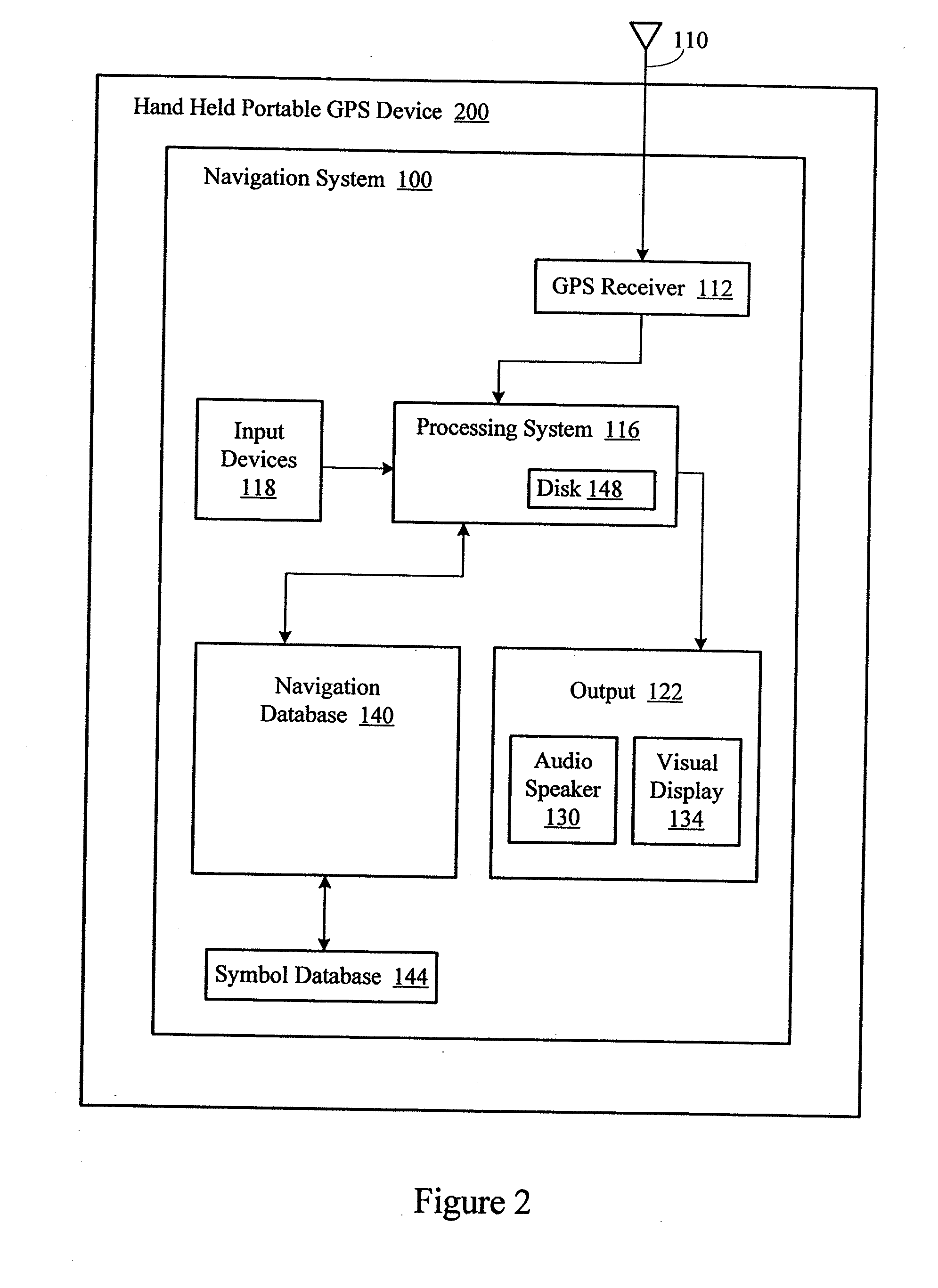
[0025]FIG. 1 shows a navigation system 100. The navigation system 100 may be installed in a vehicle 106, such as an automobile, motorcycle, ship, or airplane. The navigation system 100 may include a GPS antenna 110, typically mounted on the vehicle, and a GPS receiver 112 configured to receive the GPS signals from the antenna. The navigation system 100 may include a processing system 116 connected to the GPS receiver. The processing system 116 may receive user input from various input devices 118, and may output information on various output devices 122, such as an audio speaker 130 and a visual display 134. The processing system 116 may also be coupled to a navigation or map database 140, which may provide the user with the basic map or route. The navigation database 140 may be in turn coupled to a symbol database 144. The navigation system 100 may store computer-executable program instructions and data on a disk 148 and / or may contain non-volatile memory for such storage.

[0026] T...


PUM


Abstract

A navigation system accepts driver input that extends the navigation capabilities of the navigation system, while permitting the driver to navigate using a digital map that indicates vehicle position. The driver input may identify a new point of interest, an icon for the new point of interest, and location information for the new point of interest. The navigation system supplements a pre-configured navigation database with the driver input. During a subsequent trip, when the vehicle approaches the new point of interest, the navigation system alerts the driver of the new point of interest.

Description

PRIORITY CLAIM [0001] This application claims the benefit of priority from European Patent Application No. 06 006 441.7, filed Mar. 28, 2006, which is incorporated by reference. BACKGROUND OF THE INVENTION [0002] 1. Technical Field [0003] This disclosure relates to route guidance by a navigation system and a navigation system for a vehicle or a hand-held device. In particular, this disclosure relates to the storage and presentation of points of interest along the route. [0004] 2. Related Art [0005] Navigation systems have become standard equipment in many vehicles. Such systems typically receive GPS (Global Positioning System) satellite radio signals, which are received by a GPS antenna of the vehicle. The signals are provided to a navigation computer in the vehicle. The navigation computer processes the received GPS data, and may also process supplemental data, to determine the current position of the vehicle. The supplemental data may include data obtained from motion sensors, whe...

Claims


Application Information

Patent Timeline
Patent Type & Authority Applications(United States)
IPC IPC(8): G01C21/00G06F17/30G06F17/40
CPCG09B29/102G01C21/26G01C21/36G01C21/34G08G1/0962
Inventor MAUDERER, HANS PETER
Owner HARMAN BECKER AUTOMOTIVE SYST
Why Eureka
Try Eureka