Satellite Based Positioning

a satellite and positioning technology, applied in satellite radio beaconing, measurement devices, instruments, etc., can solve the problems of not being able to reach the precise location of the reference station, not being able to be globally available, and not being able to accurately locate the reference station, etc., to achieve the effect of expanding the usability of relative positioning

Inactive Publication Date: 2008-12-18
NOKIA CORP +1
View PDF29 Cites 95 Cited by
  • Summary
  • Abstract
  • Description
  • Claims
  • Application Information

AI Technical Summary

Benefits of technology

[0013]The invention extends the usability of relative positioning.

Problems solved by technology

When trying, for instance, to locate a friend or a child in a crowd of people, however, this accuracy is not satisfactory.
On the other hand, reference stations at precisely known locations, which would allow a more accurate relative positioning, are not globally available.

Method used


Image

  • Satellite Based Positioning
  • Satellite Based Positioning
  • Satellite Based Positioning

Examples


Embodiment Construction

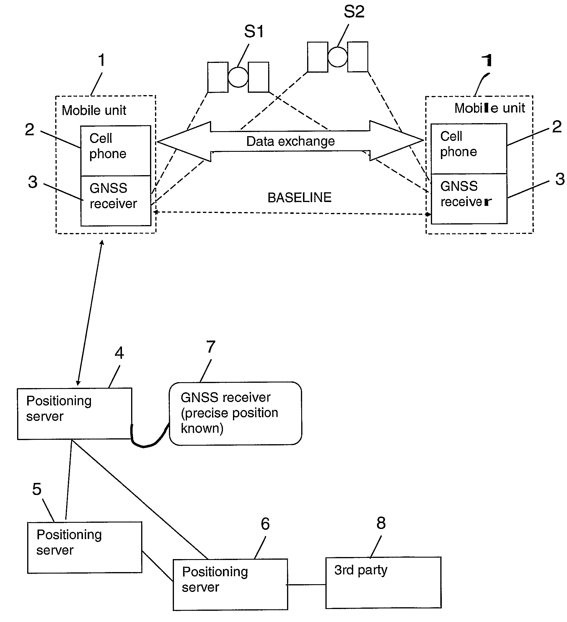
[0122]FIG. 1 presents an overview over a system in which the four aspects of the invention may be implemented by way of example. The system allows determining at least the relative position of a mobile unit.

[0123]The system comprises a plurality of mobile units 1, two of which are depicted in FIG. 1. Each mobile unit 1 includes a cellular phone 2 and a GNSS receiver 3 coupled to each other. The GNSS receiver 3 is able to receive signals which are transmitted by satellites S1, S2 belonging to one or more GNSSs, like GPS and GALILEO. The GNSS receivers 3 of two mobile units 1 are spaced apart, for example, by 10 km. It is to be understood that also much larger distances are possible, like for instance 100 km, but the performance of a relative positioning can be expected to be the better, the shorter the distance. The distance is indicated in FIG. 1 by a dashed baseline between the GNSS receivers 3. The cellular phones 2 of different mobile units 1 are able to communicate with each oth...


PUM


Abstract

The invention relates to a positioning of an assembly 1. An assembly 1 comprises a GNSS receiver 3 and a wireless communication module 2 and may exchange GNSS information with other assemblies 1 using cellular or non-cellular links. Relative positions between assemblies 1 are determined based on GNSS measurements at the assemblies 1. An API 70 supports a communication between a GNSS receiver 3 and a wireless communication module 2. A positioning is made controllable by a user interface 122. A positioning server 4, 6 may forward information from one assembly 1 to the other or take care of the position computations for assemblies 1. An absolute positioning is enabled by means of a GNSS receiver 7 arranged at a known location and coupled to such a server 4. A network of positioning servers enables an information exchange between positioning servers 4, 5, 6.

Description

CROSS REFERENCE TO RELATED APPLICATIONS[0001]This application is the U.S. National Stage of International Application Number PCT / IB04 / 003446 filed on Oct. 21, 2004 which was published in English on Apr. 27, 2006 under International Publication Number WO 2006 / 043123.FIELD OF THE INVENTION[0002]The invention relates to a satellite based positioning.BACKGROUND OF THE INVENTION[0003]Currently there are two operating satellite based positioning systems, the American system GPS (Global Positioning System) and the Russian system GLONASS (Global Orbiting Navigation Satellite System). In the future, there will be moreover a European system called GALILEO. A general term for these systems is GNSS (Global Navigation Satellite System).[0004]The constellation in GPS for example, consists of more than 20 satellites that orbit the earth. Each of the satellites transmits two carrier signals L1 and L2. One of these carrier signals L1 is employed for carrying a navigation message and code signals of ...

Claims


Application Information

Patent Timeline
Patent Type & Authority Applications(United States)
IPC IPC(8): G01S5/00G01S5/14G01S19/05G01S19/04G01S19/07G01S19/11G01S19/44G01S19/48G01S19/51
CPCG01S5/0027G01S5/0036G01S5/0072G01S19/04G01S19/05G01S19/43G01S19/44G01S19/51
Inventor SAIRO, HANNASYRJARINNE, JARI
Owner NOKIA CORP
Why Eureka
Try Eureka