Method and System for Real-time Automated Change Detection and Classification for Images

a real-time automatic change detection and image technology, applied in the field of real-time automatic change detection and image classification, can solve the problems of affecting the correlation between pixels in ssi, unable to image the area of the seabed directly below the fish, and unable to extract targets and features in sidescan imagery

Inactive Publication Date: 2009-01-15
THE UNITED STATES OF AMERICA AS REPRESENTED BY THE SECRETARY OF THE NAVY +1
View PDF1 Cites 18 Cited by
  • Summary
  • Abstract
  • Description
  • Claims
  • Application Information

AI Technical Summary

Benefits of technology

[0025]The method can also include, if no matches between the historical data and the change detection sonar survey contact are found, id...

Problems solved by technology

The side scan sonar cannot image the area of the seabed directly below the fish due to the spreading of the beams.
Further, correlation between pixels in SSI is affected by “speckle” noise, which can also hamper the extraction of targets and features in sidescan imagery.
GPS sign...

Method used


Image

  • Method and System for Real-time Automated Change Detection and Classification for Images
  • Method and System for Real-time Automated Change Detection and Classification for Images
  • Method and System for Real-time Automated Change Detection and Classification for Images

Examples


examples

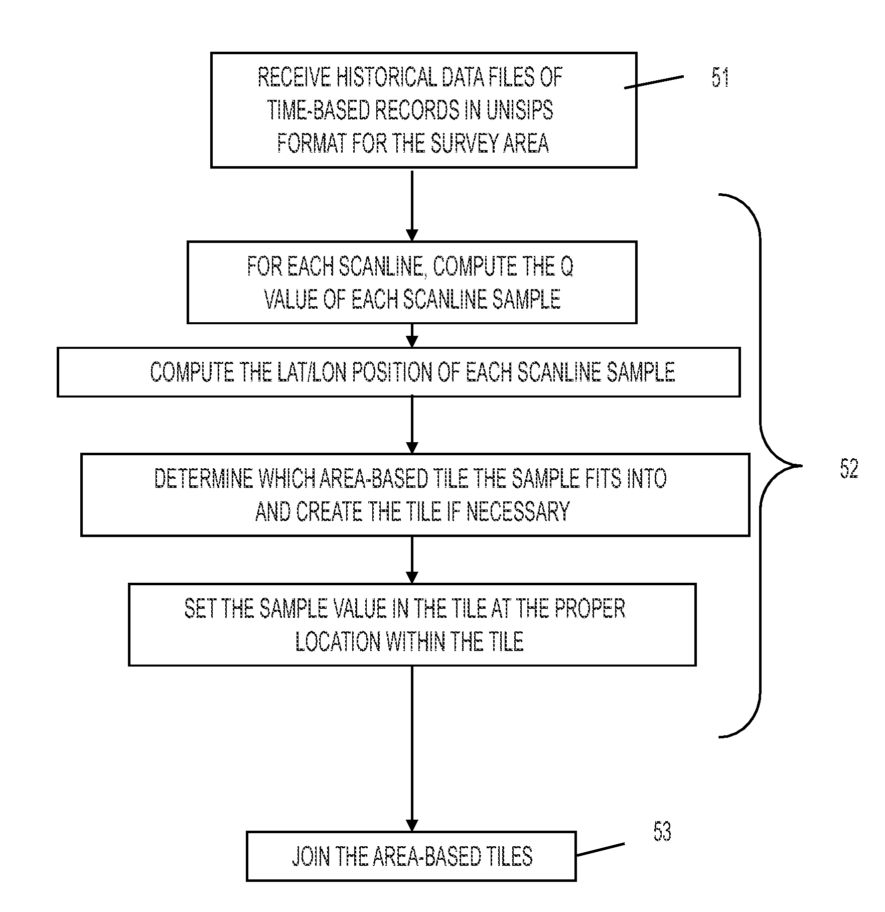
[0154]Some specimens and results are shown in FIGS. 23 and 24. In one test, the survey area consists of five one-nautical mile long lines in shallow water (20 meters) and five two-nautical mile long lines in deep water (55 meters). Since the set sonar range for the sidescan sonars was 50 meters, the survey lines were spaced at 37.5 meters to allow for 100% overlap. Baseline surveys were conducted by each sonar in the shallow and deep areas, and the location of pre-existing contacts were determined. This information was used to populate a “historical” master contact database.

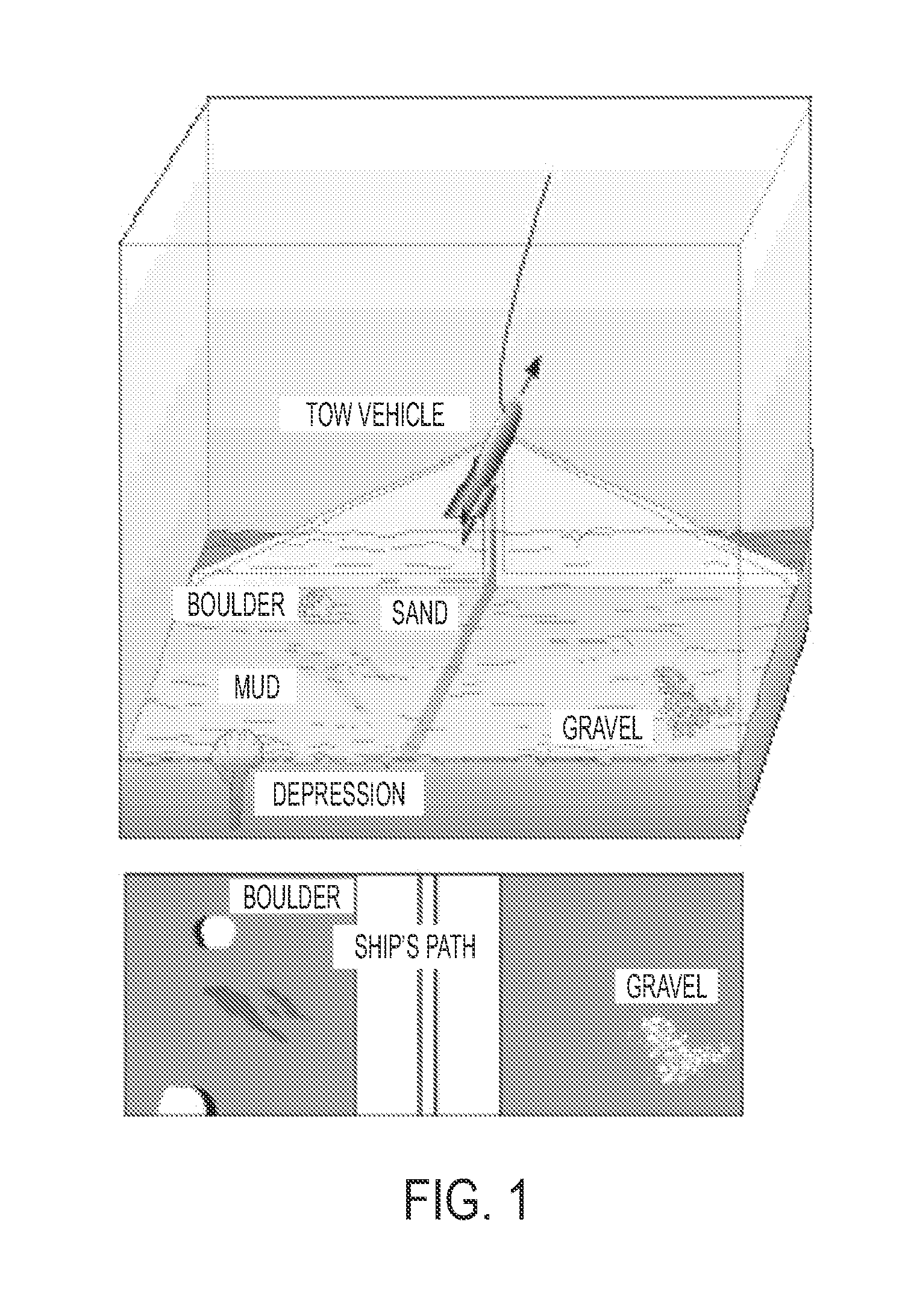
[0155]Ten objects representing mine shapes were then placed over the survey area, with five in the deep portion and five in the shallow portion. The objects were plywood boxes and lead pipes. ACDC-RT analysts missed one of each and found one of each. One possible reason for the inability to detect the missed objects was the placement of these missed mine shapes at the edge of the survey area.

[0156]Change detectio...


PUM


Abstract

A computer based system and method for real-time display of co-registered historical and current side scan sonar imagery during a side scan sonar survey. Embodiments also include modules for detection of clutter in the current imagery, identification of features, extraction of snippets, filtering based on predetermined size and shape parameters, and determination if a current feature is the same as a previously identified contact from historical imagery.

Description

CROSS-REFERENCE TO RELATED APPLICATIONS[0001]This Application is a continuation-in-part of application Ser. No. 11,949,685, filed on Dec. 3, 2007, which is a non-provisional application of provisional application (35 USC 119(e)) 60 / 868,151 filed on Dec. 1, 2006. The entire disclosures of these applications are incorporated by reference herein.BACKGROUND OF THE INVENTION[0002]Sidescan sonar was originally developed by Dr. Harold Edgerton at the Massachusetts Institute of Technology in the 1960's. Current side scan sonar systems are towed from a platform, such as a ship or helicopter, hull-mounted on a surface ship, or carried on an undersea vehicle. The undersea vehicle can be an autonomous undersea vehicle (AUV) or a towed undersea vehicle 10, as shown in FIG. 1. The sidescan sonar system transmits an acoustical beam on each side of a transducer, or “fish”. The beams are sent in a wide angular pattern down to the bottom in swaths 50-500 meters wide, and the echoes are returned creat...

Claims


Application Information

Patent Timeline
IPC IPC(8): G01S15/00
CPCG01S15/8902G01S7/539
Inventor GENDRON, MARLIN L.LOHRENZ, MAURA C.RIEDLINGER, LANCELOT M.HAMMACK, JAMES A.MARTIN, CHARLES B.
Owner THE UNITED STATES OF AMERICA AS REPRESENTED BY THE SECRETARY OF THE NAVY
Why Eureka
Try Eureka