System and method for evaluating accuracy of an automatic location identification system

an automatic location identification and system technology, applied in the field of wireless communication networks, can solve the problems of increasing the probability of errors, reducing the accuracy of automatic location identification systems, so as to reduce errors and costs, and effectively utilize automated tools

Inactive Publication Date: 2009-02-19
VERIZON PATENT & LICENSING INC +1
View PDF20 Cites 33 Cited by
  • Summary
  • Abstract
  • Description
  • Claims
  • Application Information

AI Technical Summary

Benefits of technology

[0011]Accordingly, it is an advantage of the present invention that a method and system are provided for evaluating the accuracy of an automatic location identification system (ALI).
[0012]It is another advantage of the present invention that the method and system evaluate an ALI system based on FCC accuracy and reliability requirements.
[0013]It is another advantage of the present invention that the method and system minimize error and costs by effectively utilizing automated tools for repetitive tasks.
[0014]Another advantage of the present invention is that the method and system enable completion of comprehensive validations in a timely manner with minimum need for specialized staff.
[0015]Yet another advantage of the present invention is that the method and system are operable independent from the particular ALI technology deployed.
[0016]The above and other advantages of the present invention are carried out in one form by a method for evaluating accuracy of an automatic location identification (ALI) system configured to locate a wireless communication device originating an emergency call through a wireless communication network. The method calls for identifying a validation region in which a service area of a public safety answering point (PSAP) and a radio frequency (RF) coverage area of the wireless communication network overlap. A test scenario is selected that represents a calling environment in which the emergency call may occur, and a test point is chosen in the validation region exhibiting the calling environment represented by the test scenario. The method further calls for determining a ground truth of the test point and performing a test call from the test point, the test call simulating the emergency call. A reported location of the test point is obtained from the ALI system in response to the performing operation, and the reported location is compared with the ground truth to determine the accuracy of the ALI system in response to predetermined accuracy parameters.

Problems solved by technology

Unfortunately, many mobile callers dialing 911 to report an emergency do not know exactly where they are.
This lack of spatial consciousness means operators at public safety answering points (PSAPs) may not be able determine a caller's location so that emergency response personnel can be quickly and accurately dispatched to the appropriate location.
Unfortunately, a comprehensive validation of an ALI system using current empirical observations is both costly and time consuming, and requires a wireless carrier to hire a large staff of both highly skilled and medium to low skilled personnel.
Furthermore, a comprehensive validation of an ALI system calls for a large number of repetitive tasks and significant human intervention, which increases the probability of error.

Method used


Image

  • System and method for evaluating accuracy of an automatic location identification system
  • System and method for evaluating accuracy of an automatic location identification system
  • System and method for evaluating accuracy of an automatic location identification system

Examples


Embodiment Construction

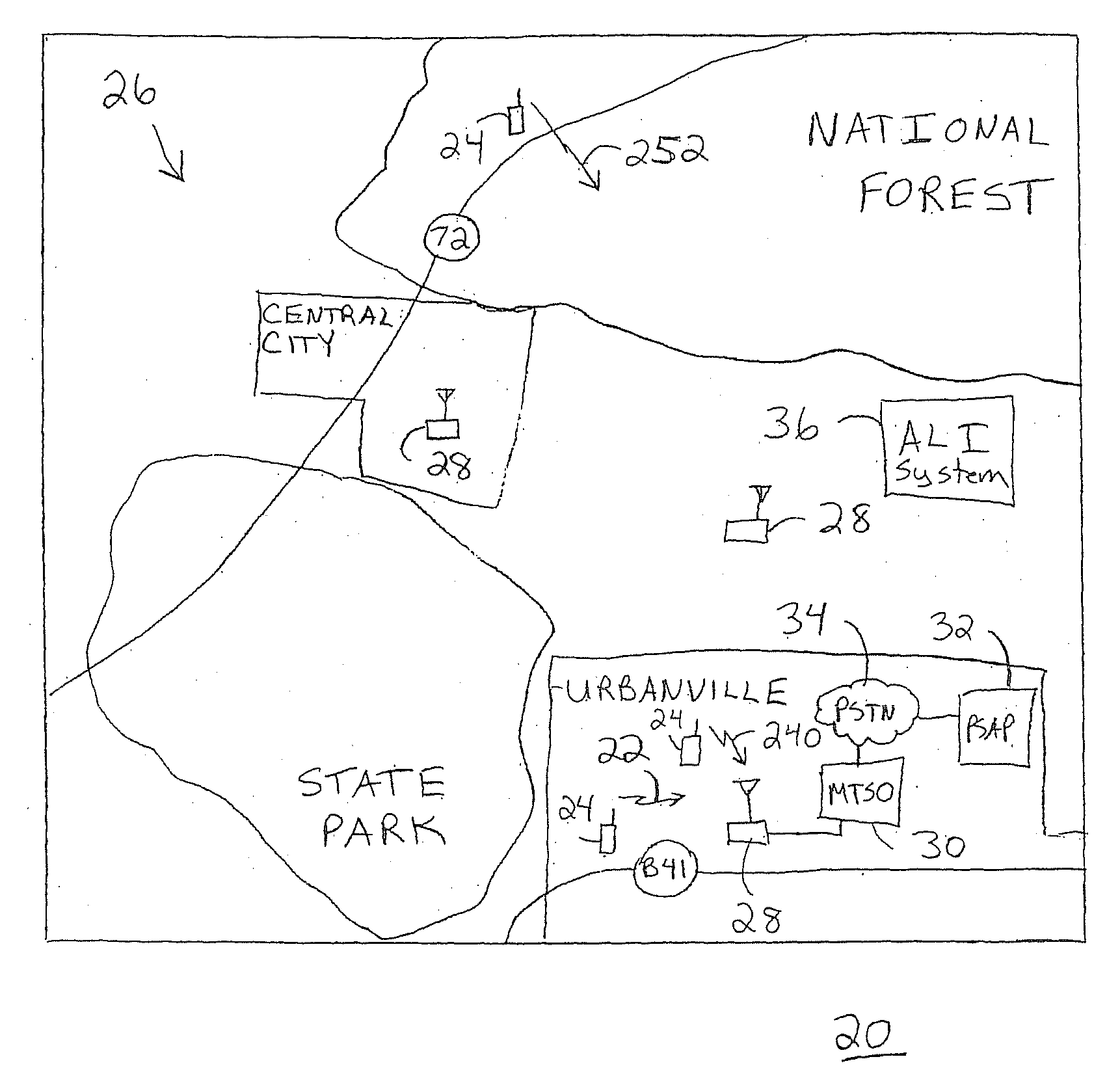
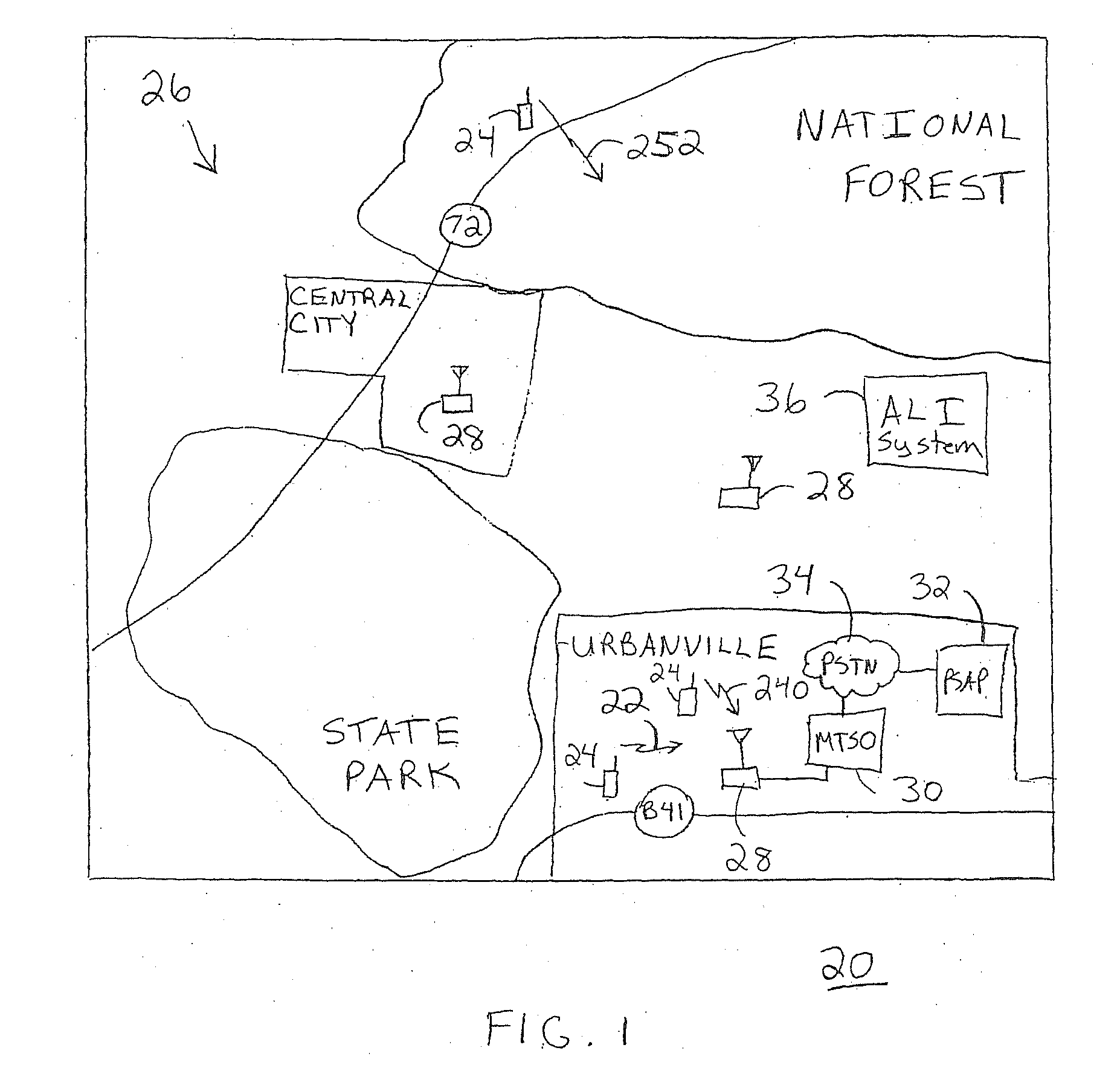
[0037]FIG. 1 shows a simplified diagram of an environment 20 in which an emergency call 22, originated from a wireless communication device 24 through a wireless communication network 26, may take place. Environment 20 represents a geographical region that may include a number of geographical and man-made features. Geographical features include, for example, hilly terrain, heavy foliage, mountains, flat land, water, and so forth. Man-made features include, for example, buildings, roads, bridges, and so forth. In the United States, emergency call 22 may be originated by dialing “911” from either a wireline telephone (not shown) or wireless communication device 24. However, emergency call 22 is not limited to the “911” digits utilized in the United States, but may encompass any digits utilized as an emergency services number in other regions or countries.

[0038]Wireless communication device 24 engages in wireless communication through one of base stations 28 of wireless communication n...


PUM


Abstract

A method (38) and system (56) evaluate the accuracy of an Automatic Location Identification (ALI) system (36) deployed within an environment (20) and configured to location a wireless communication device (24) originating an emergency call (22) through a wireless communication network (26). The method (38) includes a subprocesses that identify a validation region (144) in which a service area (106) of a public service answering point (PSAP) (32) and an RF coverage area (129) overlap, classify sub-regions within the validation region (144) according to a predetermined set of test scenarios (148) representing unique calling environments, and select test points (200) within the validation region (144) from which test calls, that simulate emergency calls, will be performed. The method (38) further includes an empirical test call execution subprocess (50) for performing test calls within the validation region (144) and a predictive test call execution subprocess (52) for simulating test calls within a simulated environment (260).

Description

CROSS REFERENCE TO RELATED CASES[0001]The present application is a continuation of U.S. patent application Ser. No. 10 / 603,131 filed on Jun. 24, 2003, the contents of which are hereby incorporated by reference.TECHNICAL FIELD OF THE INVENTION[0002]The present invention relates to the field of wireless communication networks. More specifically, the present invention relates to evaluating the accuracy of automatic location identification systems used to locate wireless communication devices originating emergency calls.BACKGROUND OF THE INVENTION[0003]Today's society is highly mobile. That is, individuals can move rapidly from one location to the next by utilizing automobiles, mass transit, bicycles, and the like. The advantages of communication any time and almost anywhere, advances in technology, and the affordability of wireless communication devices, such as cell phones, pagers, personal communications systems (PCS), and personal digital assistants (PDA) have resulted in a prolifer...

Claims


Application Information

Patent Timeline
Patent Type & Authority Applications(United States)
IPC IPC(8): H04M11/04H04W4/02H04W24/00H04W4/029H04W4/90H04W24/06
CPCH04W4/02H04W76/007H04W24/06H04W4/22H04W76/50H04W4/90H04W4/029
Inventor RAHMAN, IFTEKHAR
Owner VERIZON PATENT & LICENSING INC
Why Eureka
Try Eureka