Method For Operating A Navigation System

a navigation system and navigation system technology, applied in surveying, navigation, measurement devices, etc., can solve the problems of no longer continuously driver is unable to determine if lane changes are required, and the acoustic output of maneuvering instructions is no longer available to the user after the announcement, so as to reduce the number of lane changes

Inactive Publication Date: 2009-07-09
NAVIGON AG
View PDF7 Cites 24 Cited by
  • Summary
  • Abstract
  • Description
  • Claims
  • Application Information

AI Technical Summary

Benefits of technology

[0009]Based on this prior art, the present invention provides a new method for operating a navigation system that makes it possible to select the lanes suitable for following the calculated route in a timely and reliable fashion, as well as to altogether minimize the number of lane changes and to enable the driver to execute the required lane changes in a timely fashion.
[0010]One embodiment of the inventive method is based on the fundamental idea of calculating the lane course at the current position, particularly prior to a lane change maneuver, and the lane course during a lane change maneuver in order to display the lanes, wherein a schematic combination of both lane courses is graphically displayed on the display unit of the navigation system in the form of a schematic lane image. Consequently, the driver is provided with a clearly arranged and intuitive illustration that shows the changes of the lane course and thusly enables the driver to orient himself along the lane course in a timely fashion.

Problems solved by technology

However, known navigation systems not only calculate the route from the starting point to the destination.
With respect to a turning maneuver at an intersection, for example, the system may output the following announcement: “Please turn left at the next intersection.” However, the acoustic output of maneuvering instructions has the disadvantage that they are no longer continuously available to the user after the announcement.
However, since only the suitable lanes at the location of the maneuver are displayed, the driver is unable to determine if lane changes are required prior to the maneuver in order to reach the suitable lanes.
In this type of situation, the driver is unable to determine how the lane course will change prior to the maneuver.
Consequently, the driver may still have to execute lane changes shortly before the maneuver.
If the traffic situation does not allow such last-minute lane changes, the driver may be unable to execute the planned and displayed maneuver and may consequently be forced to diverge from the calculated route and to take a detour.

Method used


Image

  • Method For Operating A Navigation System
  • Method For Operating A Navigation System
  • Method For Operating A Navigation System

Examples


Embodiment Construction

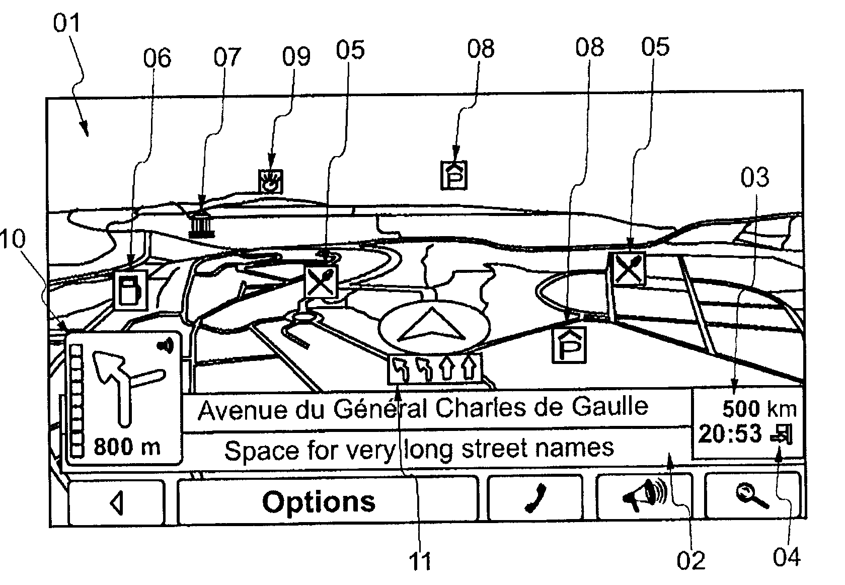
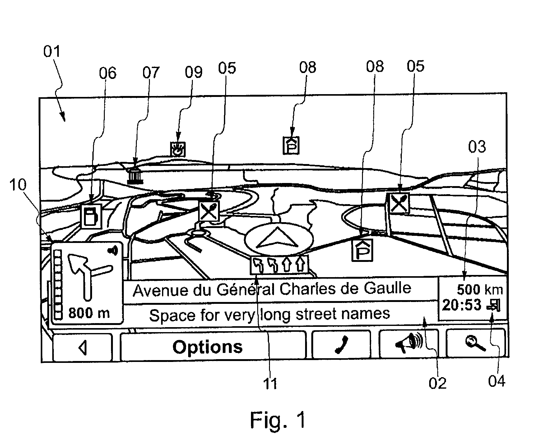
[0033]FIG. 1 shows an example of the image contents displayed on the display unit of a known navigation system. The main content consists of a top view of the immediate surroundings in the form of a map 01. A multitude of information is displayed on the map 01, as well as on the remainder of the display unit, for example, the street name 02, the distance from the destination 03, the estimated arrival time 04, the closest restaurants 05, fueling stations 06, museums 07, parking garages 08 and points of interest 09. If a route from a starting point to a destination was calculated, additional information and instructions are output in order to assist the driver in following the calculated route. This includes schematic maneuvering images 10 that schematically display the next maneuver to be executed and schematic lane images 11 that show lanes suitable for executing the next maneuver. However, the schematic lane images 11 are not very sensible and may even have a confusing effect on th...


PUM


Abstract

A method for operating a navigation system includes the following steps:a) calculating a route from a starting point to a destination, wherein the route consists of a sequence of road segments and junctions between the road segments that is selected from a database in which a geographic area is described by means of road segments and junctions with a route calculation method,b) calculating at least one lane instruction that contains instructions for the user in order to follow the calculated route in the form of a lane change maneuver based on the current position, andc) calculating and displaying a schematic lane image (12) on a display unit, wherein the schematic lane image (12) graphically displays the lane instruction in schematic form, whereinc1) a first lane course (13) is calculated that shows the lanes prior to the lane change maneuver, particularly at the current position;c2) a second lane course (14) is calculated that shows the lanes during the lane change maneuver, andc3) a combination of the first and the second lane course is displayed in the schematic lane image (12).

Description

CROSS-REFERENCE TO RELATED APPLICATION[0001]This application claims the priority benefit of German Patent Application No. 10 2008 003 395.2 filed on Jan. 8, 2008, the contents of which are hereby incorporated by reference as if fully set forth herein in their entirety.STATEMENT CONCERNING FEDERALLY SPONSORED RESEARCH OR DEVELOPMENT[0002]Not applicable.FIELD OF THE INVENTION[0003]The invention pertains to a method for operating a navigation system.BACKGROUND OF THE INVENTION[0004]Navigation systems of the generic type are used, for example, as mobile navigation devices in order to direct the driver of a motor vehicle from a starting point to a destination. For this purpose, the navigation device retrieves data from a database in which a geographic area is described in the form of road segments and junctions. Consequently, the database contains a network of road segments and junctions between these road segments that describe the road system, particularly the road network, in machine-...

Claims


Application Information

Patent Timeline
Patent Type & Authority Applications(United States)
IPC IPC(8): G01C21/36
CPCG01C21/3658
Inventor SCHMIDT, THORSTEN W.
Owner NAVIGON AG
Why Eureka
Try Eureka