Geospatial modeling system providing simulated tree trunks and branches for groups of tree crown vegetation points and related methods

a geospatial modeling and vegetation point technology, applied in the field of topographical modeling, can solve the problems of generating automated topographical models and real-looking foliage, and achieve the effect of maintaining spatial relationships and accuracy

Inactive Publication Date: 2009-08-20
TECH LICENSING CORP (US)
View PDF17 Cites 29 Cited by
  • Summary
  • Abstract
  • Description
  • Claims
  • Application Information

AI Technical Summary

Benefits of technology

[0011]This and other objects, features, and advantages are provided by a geospatial modeling system which may include a geospatial model data storage device containing geospatial model data including a plurality of groups of tree crown vegetation points and a display. The system may further include a processor cooperating with the geospatial model data storage device and the display for displaying a simulated tree trunk beneath a group of tree crown vegetation points, and displaying at least one level of simulated tree branches for the simulated tree trunk. Moreover, each tree branch may be positioned based upon determining a branch distal reference point beneath a cluster of tree crown vegetation points from among the group of tree crown vegetation points. Accordingly, the system may advantageously provide relatively realistic representations of actual trees as they would appear in a geospatial scene to preserve spatial relationships and accuracy in a corresponding geospatial model.

Problems solved by technology

One difficulty in generating automated topographical models is generating realistic looking foliage, and particularly trees.

Method used


Image

  • Geospatial modeling system providing simulated tree trunks and branches for groups of tree crown vegetation points and related methods
  • Geospatial modeling system providing simulated tree trunks and branches for groups of tree crown vegetation points and related methods
  • Geospatial modeling system providing simulated tree trunks and branches for groups of tree crown vegetation points and related methods

Examples


Embodiment Construction

[0025]The present invention will now be described more fully hereinafter with reference to the accompanying drawings, in which embodiments of the invention are shown. This invention may, however, be embodied in many different forms and should not be construed as limited to the embodiments set forth herein. Rather, these embodiments are provided so that this disclosure will be thorough and complete, and will fully convey the scope of the invention to those skilled in the art. Like numbers refer to like elements throughout, and prime notation is used to indicate similar elements in alternate embodiments.

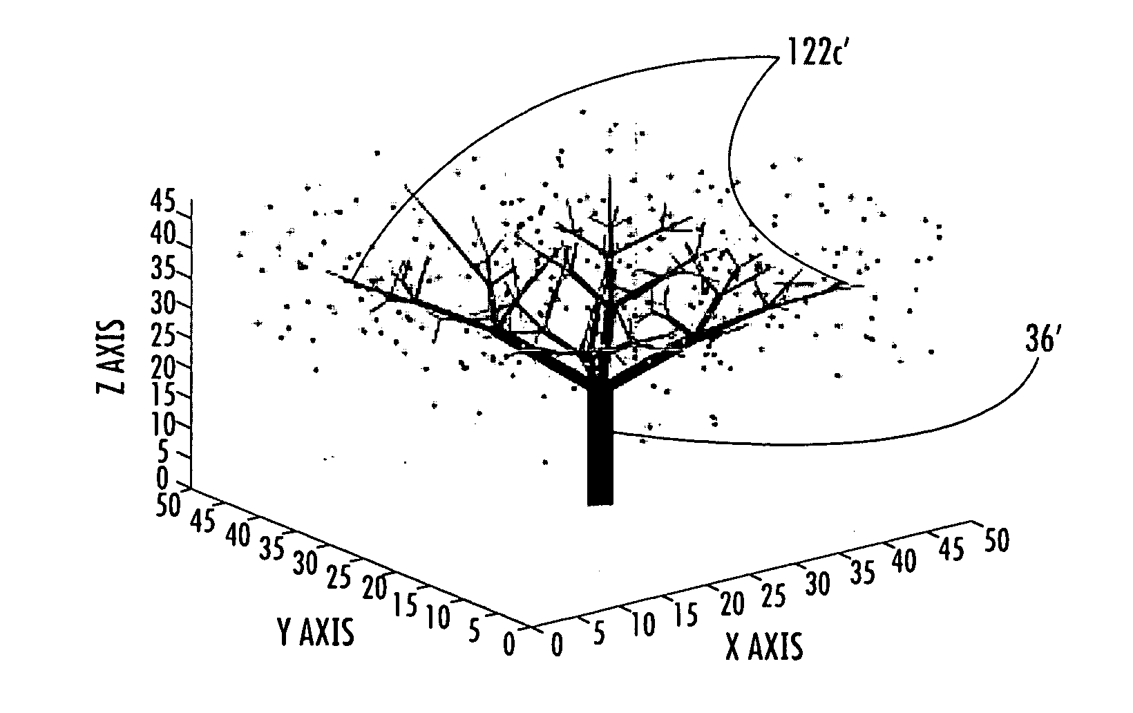
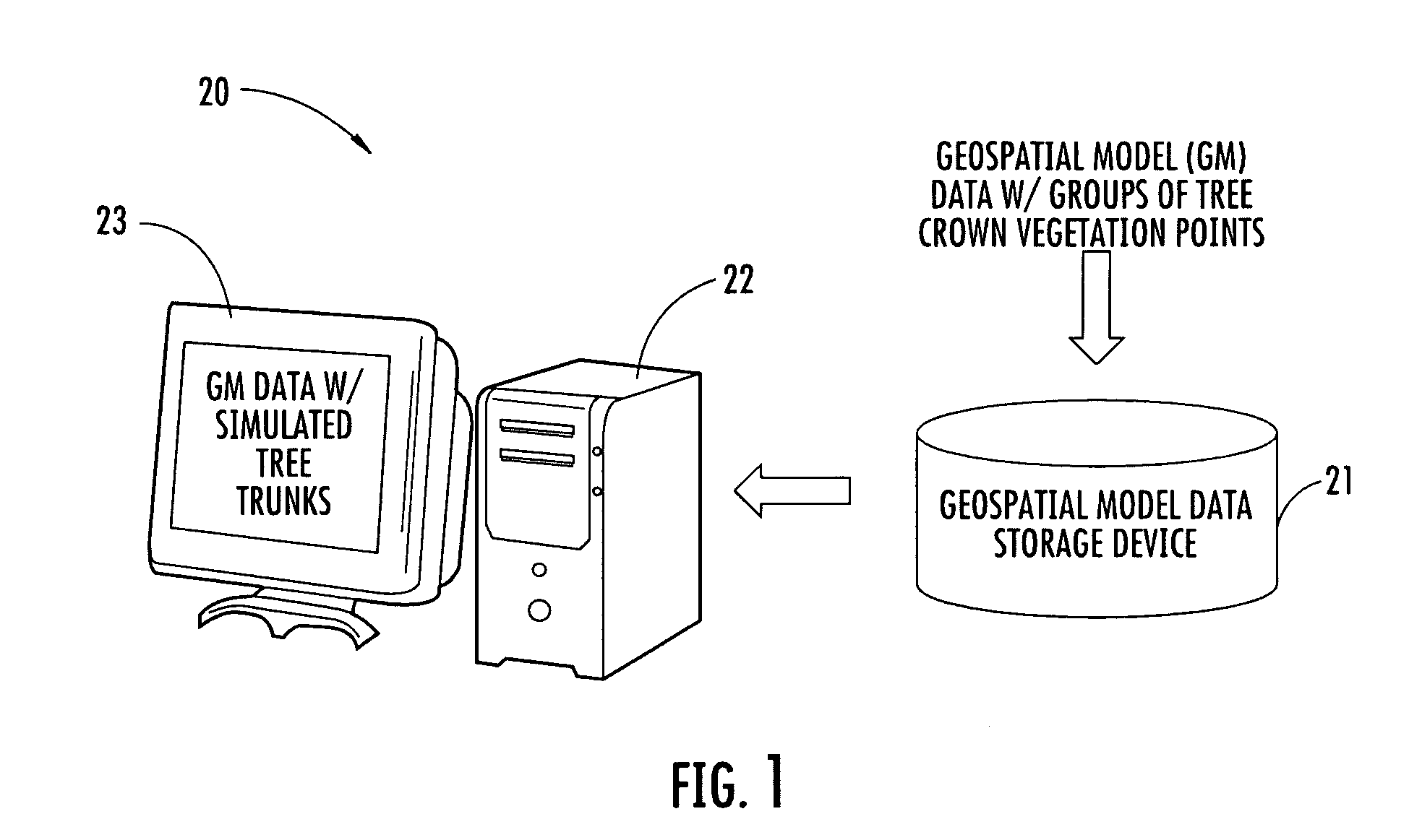
[0026]Referring initially to FIG. 1, a geospatial modeling system 20 illustratively includes a geospatial model data storage device 21 and a processor 22 that may advantageously be used for generating and displaying simulated tree trunks for groups of tree crown vegetation points from geospatial model data contained in the geospatial model data storage device. By way of example, the pr...


PUM


Abstract

A geospatial modeling system may include a geospatial model data storage device containing geospatial model data including a plurality of groups of tree crown vegetation points and a display. The system may further include a processor cooperating with the geospatial model data storage device and the display for displaying a simulated tree trunk beneath a group of tree crown vegetation points, and displaying at least one level of simulated tree branches for the simulated tree trunk. Each tree branch may be positioned based upon determining a branch distal reference point beneath a cluster of tree crown vegetation points from among the group of tree crown vegetation points.

Description

FIELD OF THE INVENTION [0001]The present invention relates to the field of topographical modeling, and, more particularly, to geospatial modeling systems and related methods.BACKGROUND OF THE INVENTION [0002]Topographical models of geographical areas may be used for many applications. For example, topographical models may be used in flight simulators and for planning military missions. Furthermore, topographical models of man-made structures (e.g., cities) may be extremely helpful in applications such as cellular antenna placement, urban planning, disaster preparedness and analysis, and mapping, for example.[0003]Various types and methods for making topographical models are presently being used. One common topographical model is the digital elevation map (DEM). A DEM is a sampled matrix representation of a geographical area which may be generated in an automated fashion by a computer. In a DEM, coordinate points are made to correspond with a height value. DEMs are typically used for...

Claims


Application Information

Patent Timeline
Patent Type & Authority Applications(United States)
IPC IPC(8): G06G7/48G06T17/05
CPCG06K9/00657G06T17/10G06T17/05G06V20/188
Inventor SULLIVAN, JOHNYATES, HARLANRAHMES, MARKFAULKNER, TIMOTHY B.HICKS, BRIAN
Owner TECH LICENSING CORP (US)
Why Eureka
Try Eureka