Aircraft navigation using the global positioning system, inertial reference system, and distance measurements

a global positioning system and inertial reference technology, applied in the field of navigation utilizing the global positioning system, inertial reference system, distance measurement equipment, etc., can solve the problems of affecting the reception of gps signals, all inertial reference systems suffer from integration drift, and inertial reference system drift error no longed could not be dynamically corrected

Inactive Publication Date: 2010-04-29
UNIVERSAL AVIONICS SYST
View PDF9 Cites 18 Cited by
  • Summary
  • Abstract
  • Description
  • Claims
  • Application Information

AI Technical Summary

Problems solved by technology

All inertial reference systems suffer from integration drift, which are small errors in the measurement of acceleration and angular velocity that become integrated into progressively larger velocity and position errors.
However, if GPS signals from a sufficient number of satellites were not received, the inertial reference system drift error no longed could be dynamically corrected.
For example, atmospherical and astronomical ...

Method used


Image

  • Aircraft navigation using the global positioning system, inertial reference system, and distance measurements
  • Aircraft navigation using the global positioning system, inertial reference system, and distance measurements
  • Aircraft navigation using the global positioning system, inertial reference system, and distance measurements

Examples


Embodiment Construction

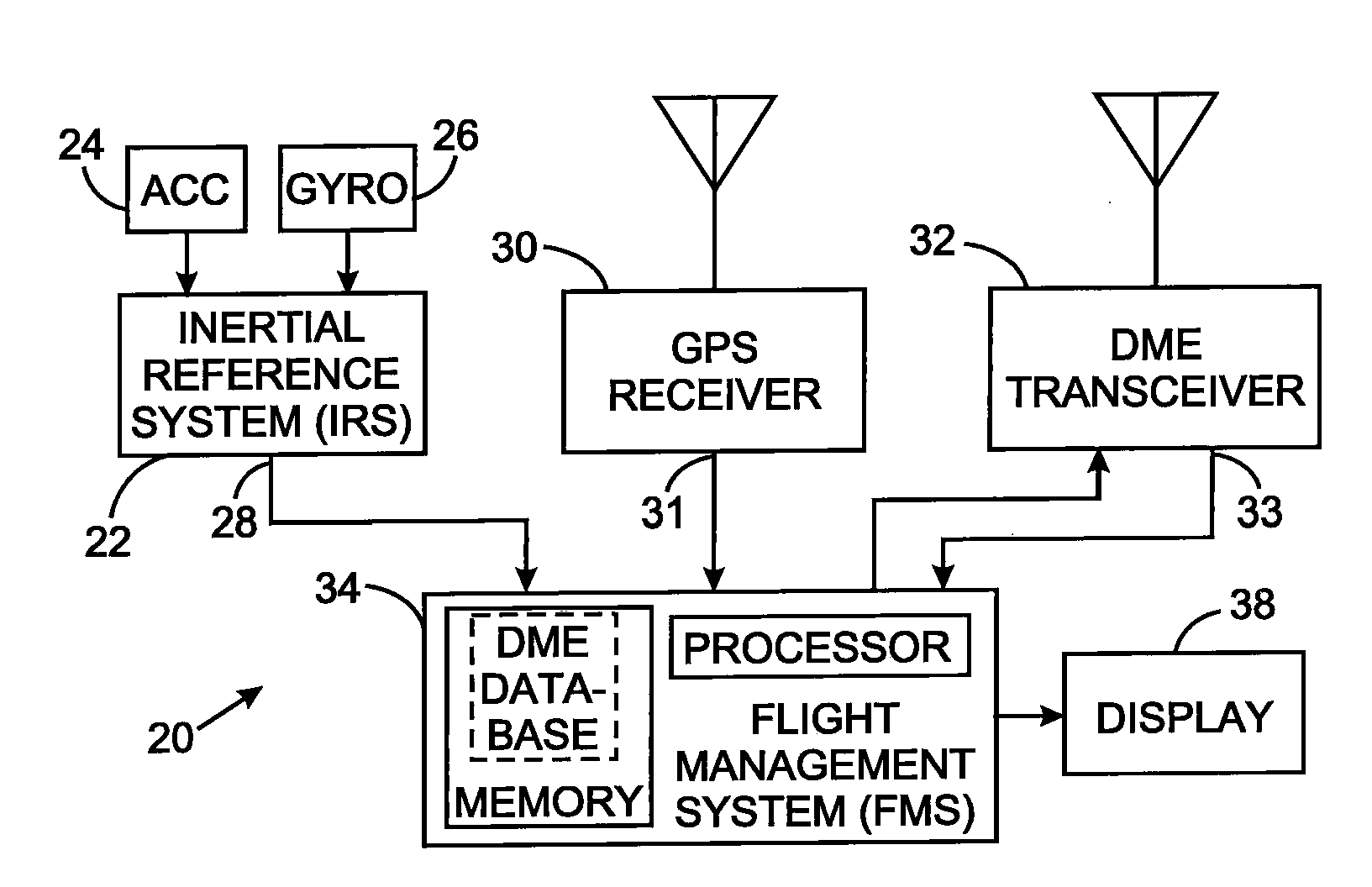
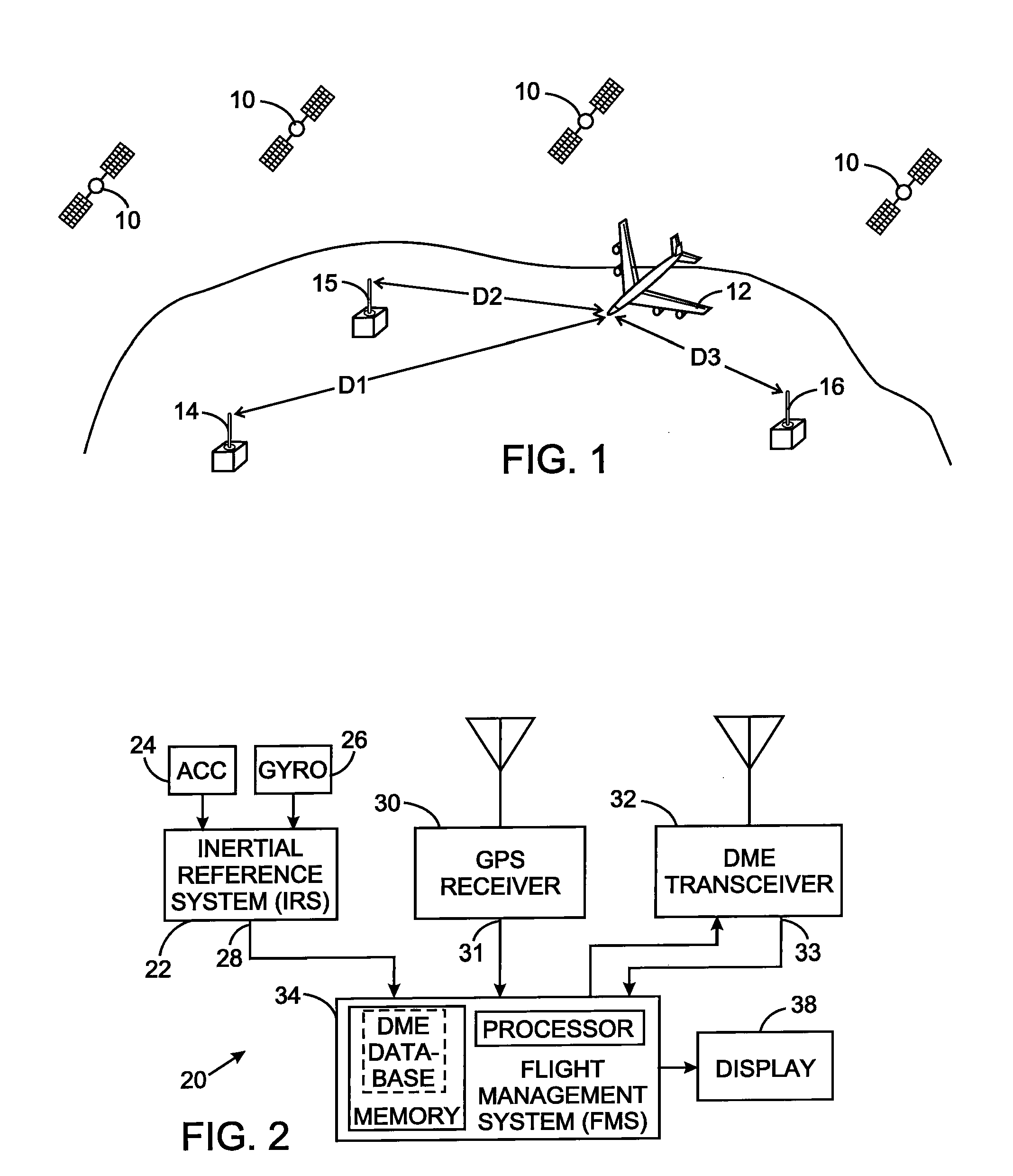
[0021]Referring initially to FIG. 1, the conventional global positioning system (GPS) comprises a plurality of satellites 10, each broadcasting a unique microwave signal. Those GPS signals from the satellites 10 can be used to determine the position of a vehicle, such as the aircraft 12. The orbits of the GPS satellites 10 are arranged in multiple planes, in order to maximize the likelihood that the aircraft 12 simultaneously receives signals from at least four GPS satellites at any arbitrary point on or near the earth. The orbits of the GPS satellites 10 are determined with accuracy from fixed ground stations and are relayed back to the respective satellite.

[0022]In navigation applications of the GPS, the latitude, longitude, and altitude of any point close to the earth, such as that of the aircraft 12, can be calculated from the propagation times of the signals from four or more of the satellites 10 to the unknown location. A measured range, often called the “pseudorange”, between...


PUM


Abstract

A navigation technique for a vehicle employs an inertial reference system to derive a first position indication and a first velocity value. A first receiver processes signals of a global positioning system from which a second position indication and a second velocity value are derived. A second receiver processes signals from a plurality of distance measuring equipment stations at fixed positions on the earth and determines the distance between the vehicle and each of those stations. A third position indication is derived from those distances. A Kalman filter function is applied to the first, second and third position indications and to the first and second velocity values to compensate for uncertainty in the first position indication and in the first velocity value and thereby produce a vehicle position estimate and a vehicle velocity estimate.

Description

CROSS-REFERENCE TO RELATED APPLICATIONS[0001]Not ApplicableSTATEMENT REGARDING FEDERALLY SPONSORED RESEARCH OR DEVELOPMENT[0002]Not ApplicableBACKGROUND OF THE INVENTION[0003]1. Field of the Invention[0004]The present invention relates to navigation and positioning systems, and more particularly to navigation utilizing the global positioning system, inertial reference system, or distance measuring equipment.[0005]2. Description of the Related Art[0006]Aircraft have traditionally used an inertial reference system (IRS) with motion sensors connected to a processor that continuously tracked the position, orientation, and velocity (direction and speed) of the aircraft without using external references. The inertial reference system was initialized on the ground by the flight crew entering the position coordinates of the aircraft, such as the longitude, latitude and altitude of the airport at which the aircraft is parked. As the aircraft moved thereafter, the inertial reference system up...

Claims


Application Information

Patent Timeline
IPC IPC(8): G01C21/00G06F17/00
CPCG01C21/165G01S19/49G01S19/15G01S19/11
Inventor YOCHUM, THOMAS E.
Owner UNIVERSAL AVIONICS SYST
Why Eureka
Try Eureka