Method, System, and Product for Managing Spatial Data in a Database

a technology of spatial data and database, applied in special data processing applications, instruments, electric digital data processing, etc., can solve the problems of complex spatial data structures that require substantial computer processing power, cells that are either too large or too small for spatial objects in the database, and cannot be easily applied to spatial data. , to achieve the effect of facilitating matching of database records, facilitating spatial data testing, and avoiding loss of performan

Inactive Publication Date: 2010-05-06
MAPTEL
View PDF8 Cites 66 Cited by
  • Summary
  • Abstract
  • Description
  • Claims
  • Application Information

AI Technical Summary

Benefits of technology

[0019]Another advantage of the spatial data system over the prior art is that applying the principles of the invention results in the need for minimal application logic in creating spatial queries. Another advantage is that the indexing method is dynamic and self-tuning to the spatial data.
[0020]Another advantage of the spatial data system is that it allows similar sized data to be grouped within the database based on the index dimension variables. Such groupings allow for more efficient testing of spatial data, for example by using such index dimension variables to more easily match database records to the area to be displayed on a computer screen.
[0021]Another advantage of the spatial data system is that it is scalable to multiple processors, distributed processing, and cloud computing because the index dimension variables can be used to partition data to run on multi-core processors or spread over multiple servers and other networked computing devices.
[0022]Another advantage of the spatial data system is that it can be implemented on flat files on top of simple indexing technology, such as B-tree indexing technology, that does not have RDBMS functionality. Accordingly, the spatial data system can be in a computing environment where RDBMS are not available, such as em

Problems solved by technology

Typically, RDBMS indexing technology uses B-Tree, Hash tables, and other similar techniques, which are well suited for single dimensional data types such as numbers and text, but not readily applicable for spatial data.
Those that do, have complex spatial data structures that require substantial computer processing power.
However, unless the spatial objects included in the database are of

Method used


Image

  • Method, System, and Product for Managing Spatial Data in a Database
  • Method, System, and Product for Managing Spatial Data in a Database
  • Method, System, and Product for Managing Spatial Data in a Database

Examples


Embodiment Construction

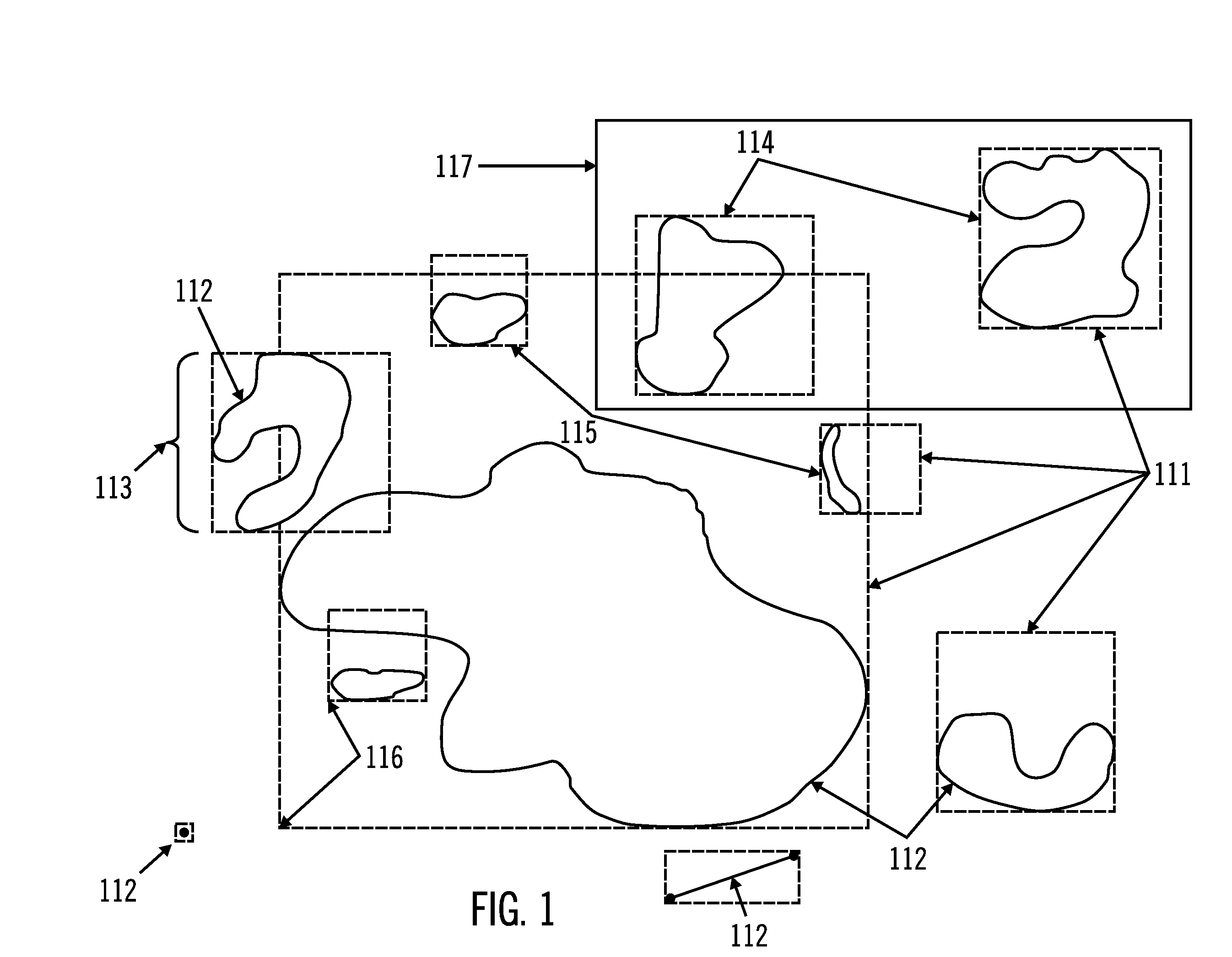
[0042]FIG. 1 depicts application of a preferred embodiment of the spatial data system on spatial objects 112, including points, lines, and polygons. Each spatial object 112 sets its own bounding shape 111 based on the size of the spatial object 112, so there is only one spatial index entry per spatial object identifier. The largest dimension 113 of the spatial object 112 determines the size of the bounding shape 111. Bounding shapes of similar sizes can be grouped according to their index dimension variables. For example, boxes of one size 114 can form one group and boxes of another size 115 can form another group. The index coordinate variables for each spatial object identifier define a single point (e.g., the extreme lower left corner 116 of the bounding shape 111). The spatial object identifier can then be indexed in the database as a function of its largest dimension and the index coordinate variables. This provides flexible spatial object data extents and avoids the requiremen...


PUM


Abstract

A method, spatial data system, and computer program product for managing spatial data stored in a database by indexing spatial object identifiers associated with spatial objects of varying dimensions using a spatial index for each spatial object identifier comprised of one or more index coordinate variables that define a single point spatially related to the spatial object and one or more index dimension variables that define a bounding shape based on the spatial object's size. The spatial data system is configured to allow querying of the database to determine spatial object identifiers, and associated spatial objects, within a search area by identifying spatial indexes that define bounding shapes intersecting the search area and producing the results on a user interface.

Description

[0001]This application claims the priority to U.S. provisional patent application Ser. No. 61 / 110,799, entitled SPATIAL KEY INDEXING, filed on Nov. 3, 2008.TECHNICAL FIELD[0002]The described technology relates to a method, system, and computer program product for managing spatial data stored in a data processing system (collectively referred to herein as “the spatial data system”), that requires less data storage and less data processing power.BACKGROUND[0003]The purpose of including spatial data in a database is to be able to query the database for information about geometric objects (e.g., architectural features, product design components, homes, parks, streets, etc.) (referred to herein as “spatial objects”) represented in the database with spatial object identifiers. The query may also be further refined to include additional conditional clauses based on non-spatial attributes within the database (such as materials, function, price, hours, and addresses). Indexing improves datab...

Claims


Application Information

Patent Timeline
IPC IPC(8): G06F17/30
CPCG06F16/29
Inventor SLAVIK, ELVINQUAN, STEPHEN
Owner MAPTEL
Why Eureka
Try Eureka