Spatial interpolation of irregularly spaced seismic data

a seismic data and spatial interpolation technology, applied in the field of spatial interpolation of seismic data, can solve the problems of missing pressure or gradient values at some locations, and achieve the effects of reducing error functions, increasing noise in pressure data, and reducing errors

Inactive Publication Date: 2010-11-25
WESTERNGECO LLC
View PDF12 Cites 22 Cited by
  • Summary
  • Abstract
  • Description
  • Claims
  • Application Information

AI Technical Summary

Benefits of technology

[0011]In a preferred embodiment, a least squares method is used to minimise the error function. However, for example, an L-1 method may be used instead of an L-2 (least squares) method.
[0012]Preferably, the operator is calculated to include a

Problems solved by technology

In general the sensors may be in the same positions, but even then there may be defecti

Method used


Image

  • Spatial interpolation of irregularly spaced seismic data
  • Spatial interpolation of irregularly spaced seismic data
  • Spatial interpolation of irregularly spaced seismic data

Examples


Embodiment Construction

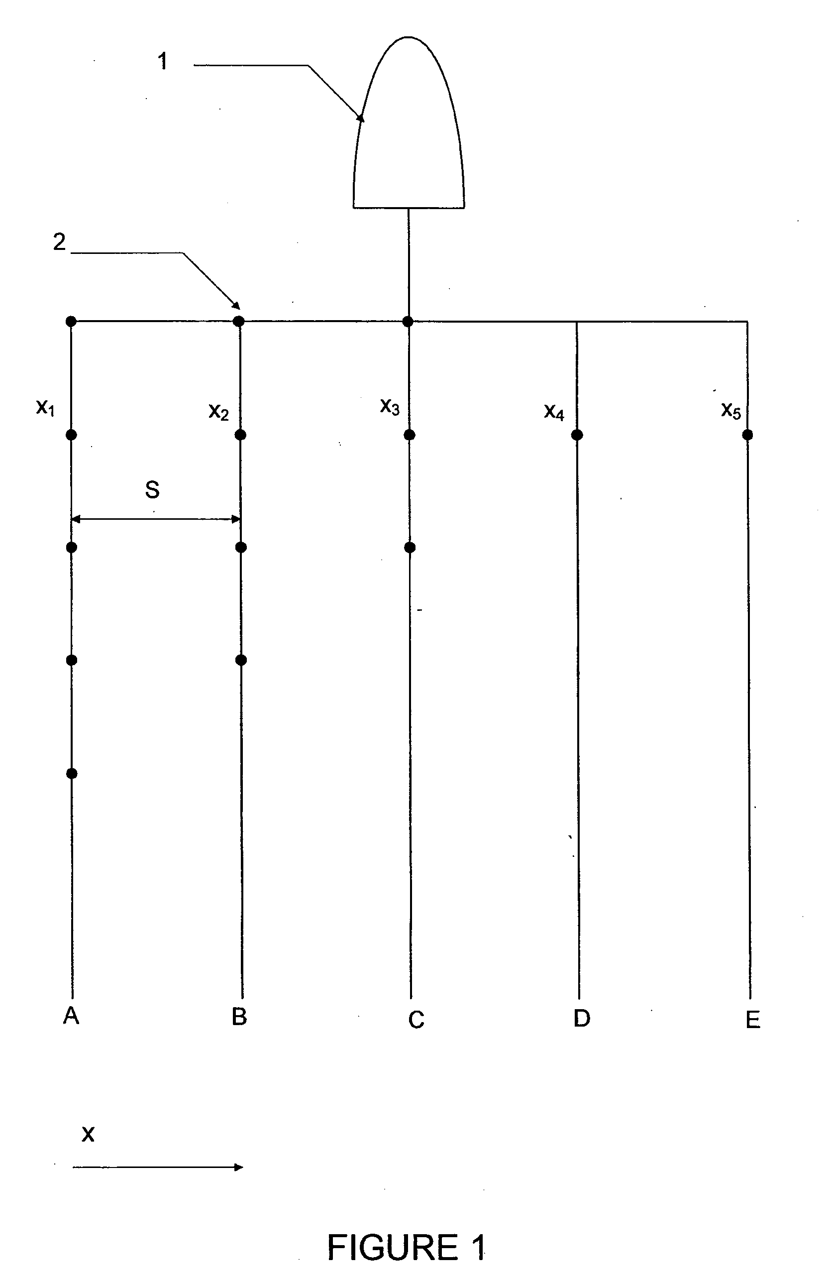
[0039]FIG. 1 illustrates a typical layout of an acquisition system for marine seismic data. A plurality of streamers, in this case five streamers A, B, C, D, E are towed behind a boat 1. The typical spacing S between the streamers A, B, C, D, E is 50 to 100 meters although the streamers A, B, C, D, E are only fixed at the end adjacent to the boat and therefore will drift so that spacing S becomes non-uniform, particularly towards the free ends of the streamers A, B, C, D, E. Each streamer A, B, C, D, E has a plurality of sensors 2 equally spaced along the length of the streamer. At each sensor position a hydrophone records pressure changes which correspond to seismic signals from reverberations from a shot fired by a source. At each sensor position xn, at least one sensor records particle velocity or acceleration. There may be multiple velocities / acceleration sensors recording the velocity / acceleration in different directions. In this case, the value of interest is the velocity / acce...


PUM


Abstract

A method for spatially interpolating pressure values of seismic data uses known values of pressure and spatial derivatives of pressure at a plurality of irregularly spaced locations along the direction of interpolation. The interpolation preferably uses an interpolation operator calculated by assuming that an interpolated pressure value comprises a linear combination of the known pressure values at locations xi and the spatial derivatives at locations Xα, with operator coefficients wi and wα respectively, and calculating the coefficients by minimising an error function.

Description

FIELD OF THE INVENTION[0001]The present invention relates to the spatial interpolation of seismic data, and particularly to the interpolation of data when known values are irregularly spaced.BACKGROUND TO THE INVENTION[0002]Seismic data are typically gathered using an array of detectors. In the case of marine data, hydrophones measure pressure fluctuations in the water caused by incoming seismic waves. Geophones measure vector quantities such as displacement, velocity or acceleration. In the case of marine data, a plurality of cables or streamers, which are spaced apart typically by about 100 metres, are towed behind a boat. Each cable has detectors spaced along the cable at intervals. In the case of land data, a geophone array is laid out on the ground with the geophones in an approximate grid formation. The detector array detects seismic signals from reverberations of a signal from a seismic source, such as an airgun for marine data. However, the detectors will not be exactly regu...

Claims


Application Information

Patent Timeline
IPC IPC(8): G01V1/28G06F19/00
CPCG01V1/28G01V2210/57G01V1/3808
Inventor MOORE, IAN
Owner WESTERNGECO LLC
Why Eureka
Try Eureka