Generating a Graphic Model of a Geographic Object and Systems Thereof

Active Publication Date: 2010-12-30
HERE GLOBAL BV
View PDF11 Cites 74 Cited by
  • Summary
  • Abstract
  • Description
  • Claims
  • Application Information

AI Technical Summary

Problems solved by technology

However, collection and processing procedures to provide geographic data for use in navigation systems may be a significant undertaking.
For example, collection of

Method used


Image

  • Generating a Graphic Model of a Geographic Object and Systems Thereof
  • Generating a Graphic Model of a Geographic Object and Systems Thereof
  • Generating a Graphic Model of a Geographic Object and Systems Thereof

Examples


Embodiment Construction

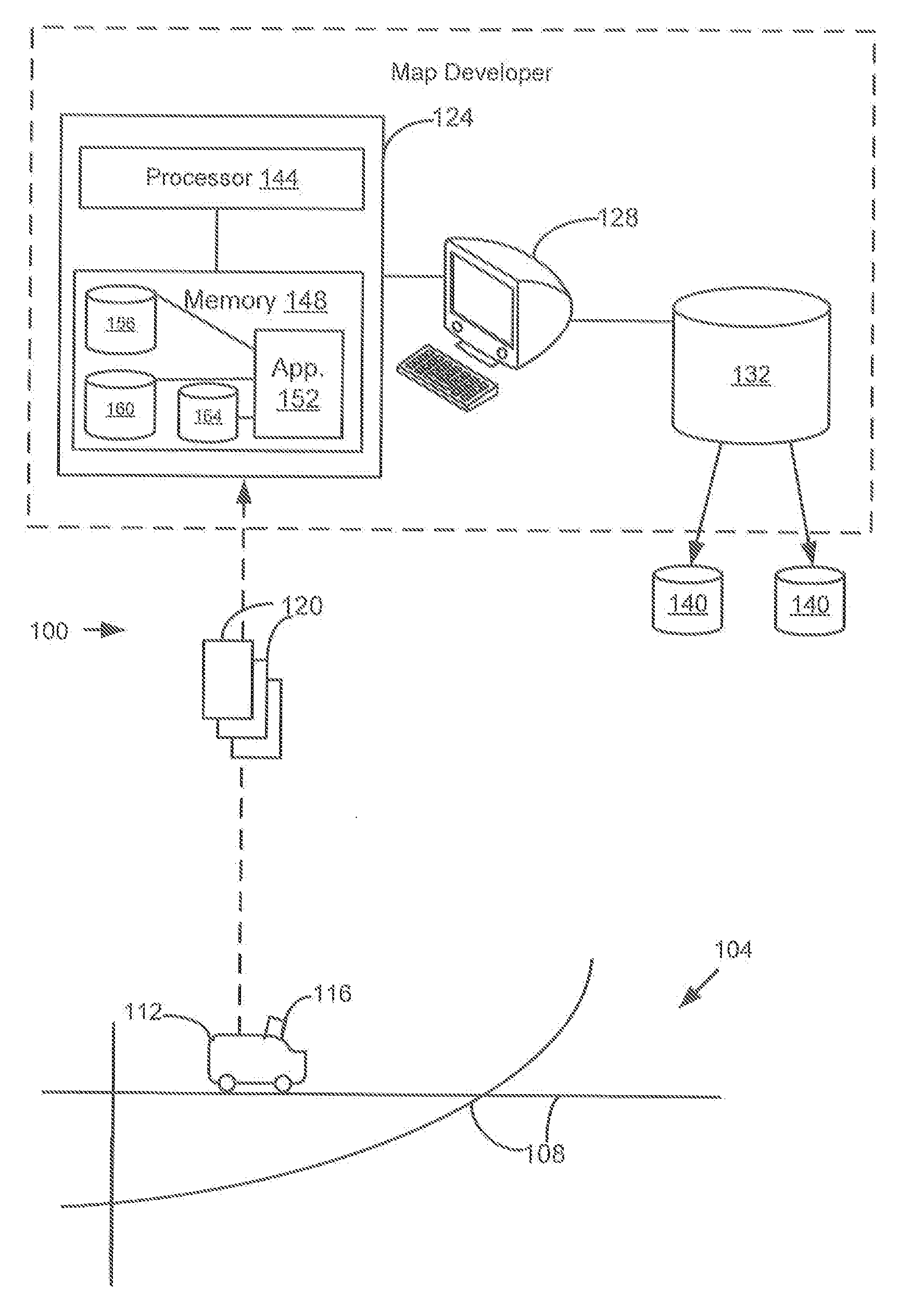
[0014]FIG. 1 shows one embodiment of a system 100 for generating, constructing, or reconstructing one or more graphic models of respective geographic objects in images to develop or enhance a navigation database. The system 100 includes, but is not limited to, an object 112 travelling on a path network 108 in a geographic region 104, a processing device 124, a user interface or work station 128, and a geographic, map, navigation, and / or navigation-related database 132. Additional, fewer, or different components may be provided.

[0015]The object 112 is a vehicle, such as a car, truck, motorcycle, bicycle, Segway, or other transportation device or mechanical device used to move on the path network 108. Alternatively, the object 112 may represent a pedestrian, such as a human being or animal, that walks or moves along the path network 108. The path network 108 is a road network and / or a collection of other pathways. For example, the path network 108 is a road network made up of various ...


PUM


Abstract

Systems, devices, features, and methods for constructing a graphic model of a geographic object, such as a road sign or features thereof, from an image, such as, for example, to develop a navigation database are disclosed. For example, one method comprises receiving a plurality of images of regions, such as of roads or paths. An image of the plurality of images is identified. A process to determine scale-invariant components of a geographic object in the identified image may be performed. Other processes, such as generating a dictionary to facilitate optical character recognition may be performed. A graphic model of the geographic object is generated based on the scale-invariant components and/or the optical character recognition. The generated graphic model may be associated with a navigation or map database.

Description

BACKGROUND OF THE INVENTION[0001]The present invention relates to analyzing and processing image data and, more particularly, to generating graphic models of geographic objects from collected images.[0002]Geographic features or objects, such as road signs or road markings, are prevalent in today's society. For example, when a person drives or walks to work or other destination, he or she usually encounters a traffic or road sign or marking on a road. Cognizance of such geographic features helps in navigating throughout various areas as well as helps in maintaining order and safety for one's self and others.[0003]Graphic models of such geographic features or objects may assist end users in a variety of applications. For example, navigation systems or devices may provide useful displays and visual guidance in instructing or guiding people to desired destinations. Navigation devices use map or geographic data, including navigation-related attributes, to provide features, such as map di...

Claims


Application Information

Patent Timeline
IPC IPC(8): G06T11/20G06F17/21G06F17/30G06V10/774G06V30/10
CPCG06K9/00818G06K9/6256G06K2209/01G06K9/00798G06T2200/08G06T2207/10016G06T2207/30252G06T11/60G06V20/588G06V20/582G06V30/10G06V10/774G06F18/214
Inventor STROILA, MATEIPERELMUTOVA, YELENA V.KOHLMEYER, BRADLEY
Owner HERE GLOBAL BV
Why Eureka
Try Eureka