
Method and system for calculating position

a technology of moving vehicles and methods, applied in the field of methods and systems for calculating the position of moving vehicles, can solve the problems of difficult to identify the peak of the correlation integration value, the integration of the correlation value of different signs, and the doppler

Inactive Publication Date: 2011-06-23
SEIKO EPSON CORP
View PDF13 Cites 25 Cited by
  • Summary
  • Abstract
  • Description
  • Claims
  • Application Information

AI Technical Summary

Benefits of technology

The invention provides a method and system for accurately calculating the position and velocity of a moving vehicle using a satellite signal. The method takes into account changes in the Doppler frequency caused by the movement of the vehicle and the detection of the satellite signal by a second unit. The method includes calculating the determination velocity, which is the velocity determined using the results of the first unit and the detection by the second unit. The error in the determination velocity is then calculated using the error in the calculation and the detection. The correlation process is performed using the determined velocity and the error in the detection. The position of the moving vehicle is then calculated using the results of the correlation process. The system includes a first unit and a second unit capable of detecting the satellite signal and calculating the position and velocity of the vehicle. The method and system provide accurate positioning even when the vehicle is moving at high speeds.

Problems solved by technology

Therefore, when the correlation values are integrated according to this reversal time, there is a problem in that correlation values of different signs are integrated.
However, increasing the correlation integration period causes other problems.
One such problem is the Doppler effect.
As a result, paradoxically, it is difficult to identify the peak of the correlation integration value if the correlation integration is performed for a predetermined period or longer.
Thus, it may not possible to capture the satellite signal even when the correlation integration period is increased.
Moreover, the error in the determination velocity is calculated using the error in the calculation by the first unit and the error in the detection by the second unit.
For example, when the moving vehicle is located in a tunnel, it may be temporarily unable to receive the satellite signal.

Method used


Image

  • Method and system for calculating position
  • Method and system for calculating position
  • Method and system for calculating position

Examples


Embodiment Construction

[0044]Hereinafter, exemplary embodiments of the invention will be described with reference to the drawings. It should be noted that embodiments to which the invention can be applied are not limited to the embodiments described below.

1. System Configuration

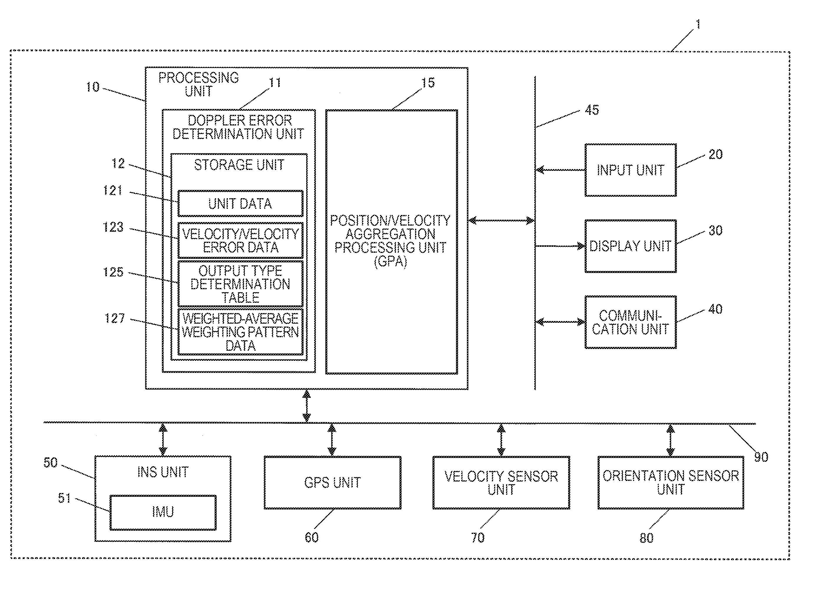
[0045]FIG. 1 is a block diagram showing a functional configuration of a position calculation system 1 (position calculation device) according to the present embodiment. The position calculation system 1 is one kind of position calculation device, and in the present embodiment, will be described as being a navigation device which is mounted on moving vehicles such as automobiles or buses. However, the position calculation system 1 can be applied to other electronic apparatuses such as a portable phone including a smart phone, a notebook-type personal computer, or a PDA (Personal Digital Assistant).

[0046]The position calculation system 1 is provided with its position relative to a moving vehicle fixed and includes an orientation sens...


PUM


Abstract

A method for calculating a position of a moving vehicle using a first unit that performs a correlation process on a satellite signal received from a satellite to capture the satellite signal and calculate the position and velocity of the moving vehicle and a second unit capable of detecting at least the velocity of the moving vehicle includes: calculating a determination velocity which is the velocity determined using the results of the calculation by the first unit and the results of the detection by the second unit; determining a correlation integration period used when the first unit performs the correlation process using the error in the determination velocity; and calculating the position of the moving vehicle using the results of the calculation by the first unit and the results of the detection by the second unit.

Description

BACKGROUND[0001]1. Technical Field[0002]The present invention relates to a method and a system for calculating the position of a moving vehicle.[0003]2. Related Art[0004]GPS (Global Positioning System) is widely known as a positioning system which uses a positioning signal and is used in a position calculation device that is provided in a portable phone, a car navigation device, and the like. In the GPS, a position calculation computation is performed so as to calculate the position coordinates and timepiece errors of the position calculation device based on information such as the positions of a plurality of GPS satellites and a pseudo-range from each GPS satellite to the position calculation device.[0005]A GPS satellite signal transmitted from a GPS satellite is modulated with spread codes, called CA (Coarse and Acquisition) codes, different for each GPS satellite. The position calculation device performs a correlation operation between the received signal and replica CA codes whi...

Claims


Application Information

Patent Timeline
Patent Type & Authority Applications(United States)
IPC IPC(8): G01S19/40
CPCG01S19/52G01S19/40
Inventor MIZUOCHI, SHUNICHI
Owner SEIKO EPSON CORP
Learn More