Method and system for multiple dataset gaussian process modeling

Inactive Publication Date: 2012-07-12
SYDNEY THE UNIV OF
View PDF11 Cites 35 Cited by
  • Summary
  • Abstract
  • Description
  • Claims
  • Application Information

AI Technical Summary

Problems solved by technology

These methods, however, do not have a statistically sound way of incorporating and managing uncertainty.
The assumption of statistically independent data is a further limitation of many works that have used these approaches.
While there are several interpolation techniques known, the independence assumption can lead to simplistic (simple averaging like) techniques that re

Method used


Image

  • Method and system for multiple dataset gaussian process modeling
  • Method and system for multiple dataset gaussian process modeling
  • Method and system for multiple dataset gaussian process modeling

Examples


Embodiment Construction

[0052]The present invention may be applied to digital terrain modeling as described hereinbelow in a non-limiting example of its implementation. Other forms of spatial data modeling may also be applicable, such as in-ground ore-grade estimation, as well as other data modeling applications which may be found in other branches of engineering or economics, including environmental sciences, hydrology, robotics and forecasting.

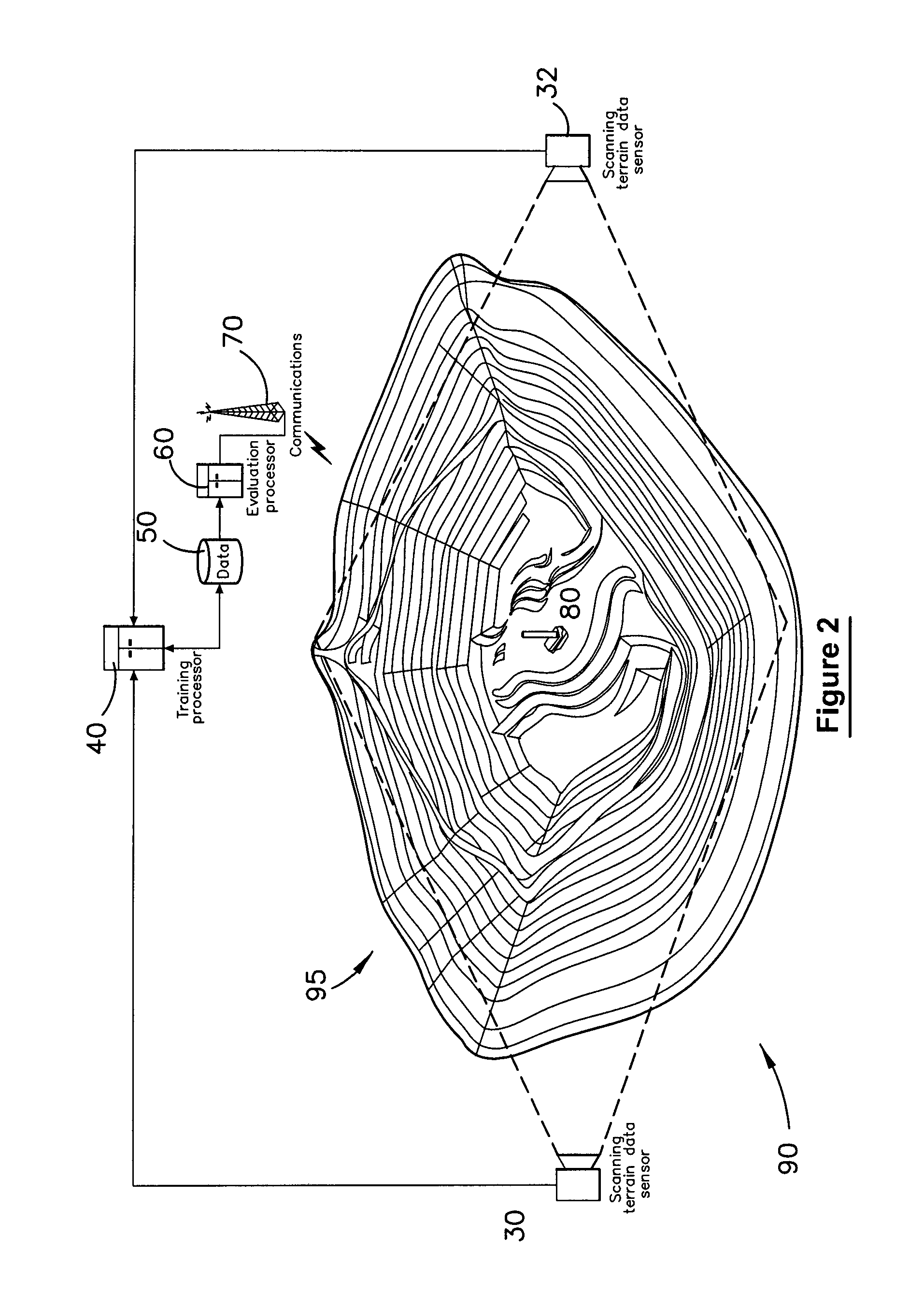
[0053]In a large scale environment like an open-cut mine spatial modeling of geography and geology can have many uses in planning, analysis and operations within the mining environment. In the case of automated mining, a geographical model or terrain map can be used to guide robotic vehicles, whilst an in-ground geological model of the ore body may be used to determine drilling and blasting operations.

[0054]A digital representation of the operating environment in the form of a spatial model can be generated from sensor measurements which provide a sample of the act...


PUM


Abstract

A method of computerised data analysis and synthesis is described. First and second datasets of a quantity of interest are stored. A Gaussian process model is generated using the first and second datasets to compute optimized kernel and noise hyperparameters. The Gaussian process model is applied using the stored first and second datasets and hyperparameters to perform Gaussian process regression to compute estimates of unknown values of the quantity of interest. The resulting computed estimates of the quantity of interest result from a non-parametric Gaussian process fusion of the first and second measurement datasets. The first and second datasets may be derived from the same or different measurement sensors. Different sensors may have different noise and/or other characteristics.

Description

FIELD OF APPLICATION[0001]This invention relates to a method and system for modeling a dataset using Gaussian processes. The invention may find numerous fields of application from which appropriate datasets may be derived including modeling mining geology or geography or economic data modeling, for example. One particular field of application considered in greatest detail herein relates to computer implemented terrain mapping for robotic navigation and the like.BACKGROUND[0002]In a large scale environment like an open-cut mine, spatial modeling of geography and geology can have many uses in planning, analysis and operations within the environment. In the case of automated mining, a geographical model or terrain map can be used to guide robotic vehicles, whilst an in-ground geological model of the ore body may be used to determine drilling and blasting operations.[0003]A digital representation of the operating environment in the form of a spatial model is typically generated from sen...

Claims


Application Information

Patent Timeline
IPC IPC(8): G06F15/18G06F17/10
CPCG01S17/89G06T2207/10028G06T7/0057G06F17/18G06T7/521
Inventor VASUDEVAN, SHRIHARIRAMOS, FABIO TORETONETTLETON, ERICDURRANT-WHYTE, HUGH
Owner SYDNEY THE UNIV OF
Why Eureka
Try Eureka